
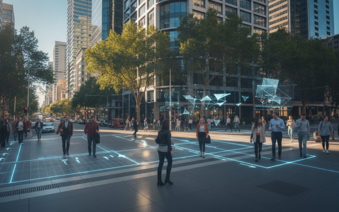
Pedestrian safety is no longer a qualitative “add-on” for a development application; it is a data-driven modelling requirement that can make or break your council approval. Most developers understand the frustration of council delays caused by inadequate safety data or confusion over complex Australian Standards. When assessing pedestrian safety in traffic impact reports, a surface-level overview is no longer sufficient to satisfy rigorous planning authorities.
You’ve likely struggled to balance efficient vehicle flow with the granular requirements of pedestrian access and safety. This guide explains how sophisticated pedestrian movement modelling and technical safety assessments ensure your development meets Australian regulatory standards while streamlining the DA process. We’ll detail the methodologies required for a compliant Traffic Impact Assessment (TIA), including the application of the Highway Capacity Manual 7th Edition standards to minimise liability and maximise safety through expert-led analysis.
Key Takeaways
- Understand the regulatory shift towards “Vulnerable Road User” protection and its impact on modern Traffic Impact Assessment (TIA) requirements.
- Learn how pedestrian movement modelling identifies potential site bottlenecks and ensures efficient foot traffic flow for large-scale developments.
- Master the Pedestrian Level of Service (PLOS) metric to objectively grade the quality of your project’s walking environment from A to F.
- Discover the technical requirements for assessing pedestrian safety in traffic impact reports to ensure full compliance with Australian Standards and local council expectations.
- Gain insights into how expert-led mitigation strategies and senior engineering representation can reduce project liability and expedite your DA approval.
The Critical Role of Pedestrian Safety in Traffic Impact Assessments
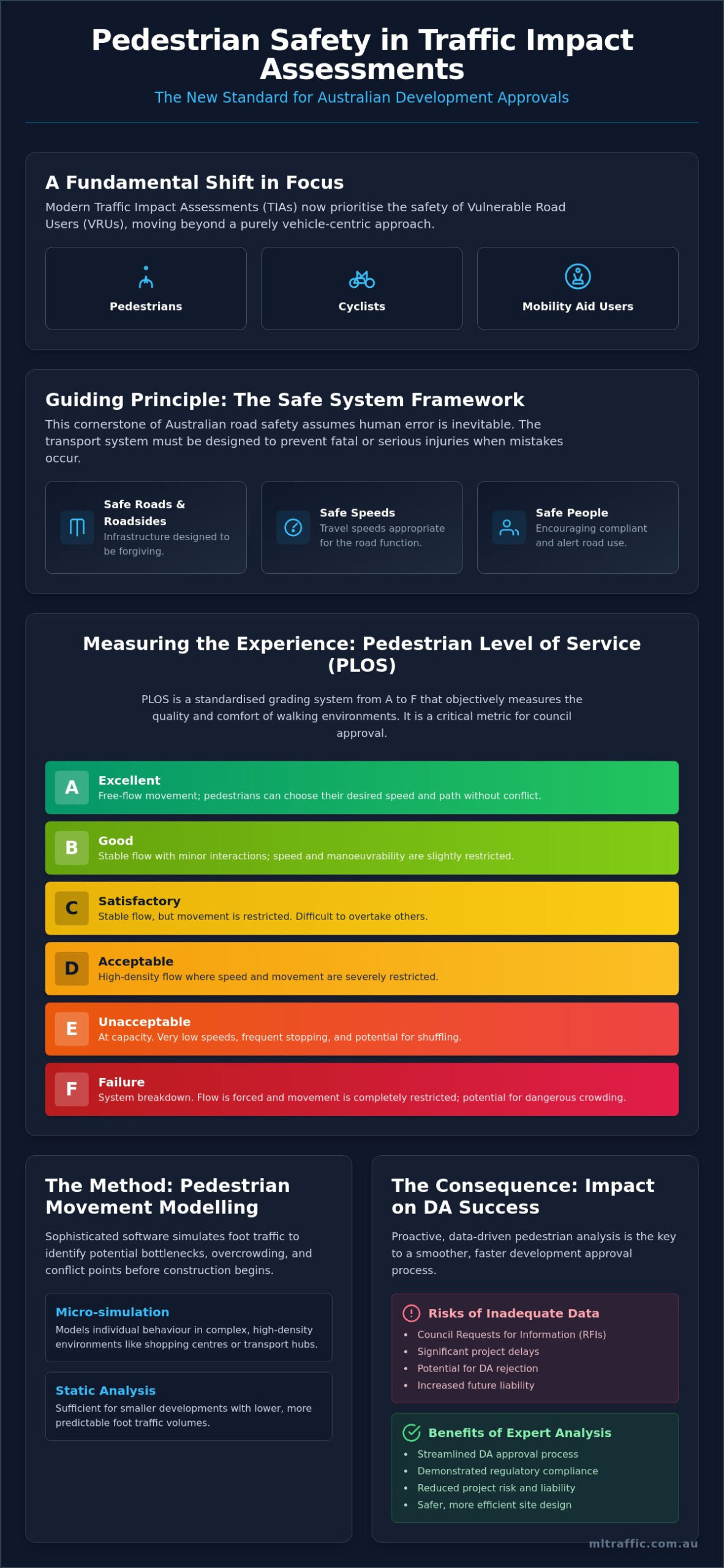
Assessing pedestrian safety in traffic impact reports involves quantifying the risk and efficiency of foot traffic within and around a proposed site. Historically, TIAs focused almost exclusively on vehicle delay and intersection capacity. However, Australian urban planning in 2026 has shifted significantly toward the protection of “Vulnerable Road Users” (VRUs). This category encompasses pedestrians, cyclists, and individuals using mobility aids. Developers must now demonstrate that their project does not just accommodate vehicles, but actively facilitates safe, permeable pedestrian environments.
Councils now frequently prioritise pedestrian permeability and safety over vehicle through-speed. This shift is driven by a focus on active transport and the legal necessity to reduce conflict points between heavy vehicles and foot traffic. Failing to address these requirements leads to significant project delays or rejection during the planning phase.
To better understand the technical components of these studies, watch this helpful overview:
The Safe System Framework in Australian Planning
The Safe System approach is the cornerstone of modern Australian road safety. It operates on the principle that human error is inevitable; therefore, the transport system must be designed to prevent fatal or serious injuries. This framework focuses on safe roads, safe speeds, and safe people. Local council Development Control Plans (DCPs) increasingly mandate that developers integrate holistic safety data into a standard traffic impact assessment. By quantifying the Pedestrian Level of Service (PLOS), engineers provide a technical basis for site designs that adhere to national safety standards.
Impact on Development Application (DA) Success
Inadequate pedestrian data is a primary cause for councils to issue a Request for Information (RFI). Common triggers include poorly defined crossing points, insufficient sight distances at driveway interfaces, or a lack of connectivity to existing footpaths. A proactive safety report prevents these costly delays by addressing potential hazards before the council identifies them. Comprehensive pedestrian safety data acts as a technical insurance policy, protecting developers against future liability and ensuring a smoother path to planning approval.
While engineers focus on design, understanding the legal ramifications of safety failures is also vital; you can learn more about Temecula Valley Injury Attorneys to see how legal experts approach liability and injury prevention.
Pedestrian Movement Modelling for Public Spaces
Pedestrian movement modelling is a technical simulation used to predict how individuals traverse a physical environment. For large-scale developments, this analysis is a mandatory requirement. It allows engineers to identify potential bottlenecks and overcrowding issues before the first brick is laid. When assessing pedestrian safety in traffic impact reports, we use sophisticated software to simulate foot traffic patterns. This process ensures that the proposed infrastructure can handle peak demand without compromising user safety.
The value of modelling is most evident in complex environments such as major shopping centres or transport hubs. In these spaces, the interaction between delivery vehicles, private cars, and pedestrians is constant. Modelling provides a data-driven foundation for segregating these movements. It ensures that high-volume pedestrian corridors remain unobstructed by vehicle manoeuvres or loading operations. Without this simulation, developers risk building sites that are inherently dangerous or operationally inefficient.
Micro-simulation vs. Static Analysis
The choice between micro-simulation and static analysis depends on project scale. Dynamic micro-simulation models individual agent behaviour in high-density public spaces. It provides a granular view of how crowds move through gates, stairs, and corridors. Static analysis is typically sufficient for smaller residential or commercial developments with lower foot traffic volumes. A critical part of this process is performing a swept path analysis. This technical check identifies exactly where vehicle turning circles overlap with pedestrian refuge islands or footpaths, allowing for immediate design corrections.
Identifying and Mitigating High-Conflict Zones
Effective safety planning requires mapping “desire lines.” These represent the most direct paths pedestrians naturally prefer to take. If a design ignores these lines, pedestrians will often bypass official crossings to save time, creating high-risk conflict zones. We specifically assess driveway crossovers and loading dock interfaces where vehicle-pedestrian interactions are most frequent. Based on the modelling results, we propose technical mitigation strategies. These may include realigning footpaths, installing bollards, or adjusting site entry points to enhance visibility. The senior principals at ML Traffic Engineers Australia provide detailed traffic modelling services to ensure your site design satisfies both safety requirements and operational needs.
Evaluating Pedestrian Level of Service (PLOS)
Evaluating Pedestrian Level of Service (PLOS) is a core requirement when assessing pedestrian safety in traffic impact reports. PLOS is a technical metric used to quantify the operational performance of a walking environment. It provides a standardised way to measure how well a facility serves its users. The system uses a grading scale from A to F. Grade A represents an environment where pedestrians move freely at their own pace. Grade F indicates a complete breakdown of flow, where overcrowding creates significant safety hazards and discomfort.
A high PLOS grade is often a prerequisite for commercial success. In retail or mixed-use developments, the quality of the walking environment directly influences footfall. If a site is difficult to navigate or feels unsafe, potential customers will avoid it. Our reports provide the technical evidence councils need to see that a development prioritises these user experiences.
Quantitative Metrics: Flow, Density, and Space
Traffic engineers use specific mathematical formulas to determine a PLOS grade. We first calculate the effective walkway width. This measurement accounts for the total width minus any physical obstructions like light poles, benches, or signage. We then analyse pedestrian density, which is the number of people occupying a square metre of space at any given time. High density leads to lower PLOS grades and increased conflict risks.
Delay is another critical quantitative factor. We measure the time pedestrians spend waiting at signalised crossings or unsignalised intersections. Excessive wait times often lead to “risky” crossing behaviours, such as darting between gaps in traffic. We use Australian Standards to justify all space allocations and crossing designs within the TIA. This ensures the proposed infrastructure is fit for purpose and compliant with national safety guidelines.
Qualitative Factors: Comfort and Connectivity
Assessing pedestrian safety in traffic impact reports requires looking beyond raw numbers. Comfort and connectivity are vital qualitative components. Factors such as adequate lighting, overhead shade, and “active frontages” improve the perceived safety of a space. Active frontages provide passive surveillance, which discourages antisocial behaviour and makes pedestrians feel more secure after dark.
For developers and event organisers, particularly in Queensland, engaging experts like Tupper Security Services provides an extra layer of protection that works in tandem with technical safety infrastructure to ensure public environments remain secure.
Accessibility is also a primary concern. Every development must comply with the Disability Discrimination Act (DDA). This involves assessing ramp grades, tactile ground surface indicators, and the continuity of accessible paths of travel. Expert traffic engineering balances these qualitative needs with technical requirements. The result is a precinct that isn’t just safe on paper, but truly walkable and accessible for the entire community.
Designing for Safety: Mitigation Strategies in TIA Reports
Assessing pedestrian safety in traffic impact reports is only effective if the technical findings result in actionable site design improvements. We translate raw data from movement modelling and PLOS grades into specific physical treatments. This process ensures the final layout adheres to Australian Standards, particularly AS 2890.1, which governs the critical interface between car parks and pedestrian areas. Councils expect standardised safety treatments that have been proven to reduce vehicle-pedestrian conflicts in high-traffic environments.
A compliant TIA report must do more than identify risks; it must provide engineered solutions. These solutions serve as a blueprint for the developer’s civil team. By integrating these strategies early, you reduce the likelihood of expensive retrofitting or council-mandated redesigns later in the project lifecycle.
Traffic Calming and Crossing Treatments
Effective mitigation often involves physical speed reduction measures within the site boundary. Raised threshold crossings are highly effective in mixed-use developments. These treatments physically force drivers to decelerate while providing pedestrians with a level, highly visible walking surface. Speed humps and chicanes are also standard tools used to manage internal site speeds and protect foot traffic.
In high-density precincts, we often design “shared zones” where pedestrians and vehicles coexist safely. These zones require specific pavement textures, signage, and lighting to signal pedestrian priority to drivers. We also specify the strategic placement of bollards and physical barriers. These elements protect vulnerable footpaths and building entries from accidental vehicle incursions, especially in areas with frequent delivery vehicle movements.
Sight Distance and Visibility Standards
Ensuring adequate visibility is a non-negotiable technical requirement for any compliant traffic report. We calculate minimum sight lines at driveway exits based on the specific speed environment and the types of vehicles expected to use the site. This process involves meticulous planning of the “sight triangle” to ensure drivers can see approaching pedestrians before crossing a footpath. Maintaining clear, unobstructed sight lines is the primary technical method for preventing accidents at vehicle-pedestrian conflict points.
We actively manage the placement of landscaping, signage, and boundary fences to prevent visibility obstructions. Even minor plant growth or poorly positioned signs can create dangerous blind spots. Our senior engineers provide professional Sight Distance Assessments to ensure your project meets all regulatory safety benchmarks and secures council approval without delay.
Navigating Planning Approvals with Expert Traffic Engineering
Securing a Development Application (DA) requires a strategic presentation of technical data that satisfies council planners and reduces long-term liability. Professional modelling is a critical component of this strategy. When assessing pedestrian safety in traffic impact reports, ML Traffic Engineers Australia provides technical depth that generic, “off-the-shelf” reports cannot match. These generic documents often fail to address site-specific movement concerns, leading to costly RFIs and project delays.
The primary benefit of engaging a specialised firm is the ability to have a senior traffic engineer defend the technical findings during council negotiations. We don’t use gatekeepers; the principal engineer who performs the technical work is the same person who represents the project in meetings. This direct accountability ensures that complex pedestrian movement queries are answered with technical precision. This builds trust with planning authorities and accelerates the approval timeline.
Compliance with Australian Standards
Adherence to national regulatory frameworks is the foundation of a successful TIA. Every report we produce follows a rigorous internal process to ensure full compliance with both local council requirements and national standards. Key elements include:
- Verification of AS 2890.1 compliance for all car park and pedestrian interfaces.
- Detailed intersection analysis using industry-standard movement modelling software.
- Documentation of sight distance compliance at all vehicle access points.
- Evidence-based PLOS grading for all primary pedestrian corridors.
With over 15 years of experience across thousands of diverse project environments, we understand the specific bureaucratic requirements of Australian councils. This expertise allows us to anticipate potential objections and address them within the initial report, preventing the need for secondary assessments.
Securing Your DA Approval
The final step in the process is the seamless integration of pedestrian safety data into your comprehensive DA package. A robust report doesn’t just satisfy a requirement; it acts as an insurance policy for the developer. It demonstrates a commitment to public safety and meticulous site design. Our senior principals remain available for technical clarifications, providing the continuity and reliability needed for complex developments. Contact ML Traffic Engineers Australia to discuss your project’s pedestrian movement modelling needs.
Securing Project Approval Through Technical Excellence
Pedestrian safety is no longer a secondary consideration in the Australian planning landscape. Success depends on technical precision, from calculating Pedestrian Level of Service (PLOS) to implementing engineered mitigation strategies like raised threshold crossings. By assessing pedestrian safety in traffic impact reports with data-driven modelling, developers can proactively address council concerns and minimise project liability. A robust report acts as a technical insurance policy for your site design.
ML Traffic Engineers Australia brings over 15 years of traffic engineering excellence to every project. We provide national expertise in Australian Standards and specific council requirements, ensuring your TIA is compliant and authoritative. You receive direct principal involvement in every report, meaning the senior expert who performs the technical work is the one who defends it during negotiations. Get expert pedestrian safety modelling for your next DA and ensure your development meets the highest safety benchmarks for a smooth approval process.
Frequently Asked Questions
Why does my traffic report need a specific section on pedestrian safety?
Modern Australian planning schemes mandate the protection of vulnerable road users as a core requirement. Councils now prioritise pedestrian permeability and safety as heavily as vehicle flow. Assessing pedestrian safety in traffic impact reports ensures the project complies with local Development Control Plans (DCPs) and reduces the developer’s long-term liability by identifying potential hazards before construction begins.
What software is used for pedestrian movement modelling in Australia?
Traffic engineers typically use industry-standard software such as SIDRA INTERSECTION for intersection-level analysis or Vissim and Legion for complex micro-simulation. These tools allow for the precise modelling of foot traffic patterns, density, and delays. Using verified software ensures that the data presented in the TIA meets the technical standards required by state transport authorities and local councils.
How does council define a “safe” pedestrian environment?
A safe environment is defined by its adherence to Australian Standards, specifically regarding sight distances, walkway widths, and crossing treatments. Councils look for designs that minimise conflict points between vehicles and people. Technical metrics like the Pedestrian Level of Service (PLOS) are used to objectively measure whether the environment provides adequate space, comfort, and connectivity for all users.
Do small residential developments require pedestrian movement modelling?
Modelling requirements depend on the scale of the development and the expected foot traffic volume. While small residential sites may only require a static analysis of driveway interfaces and sight distances, larger mixed-use or high-density residential projects often mandate dynamic micro-simulation. Developers should consult their traffic engineer to determine the specific level of assessment required by their local council’s planning guidelines.
What is the difference between a Road Safety Audit and a pedestrian safety assessment?
A pedestrian safety assessment is a predictive component of a Traffic Impact Assessment (TIA) focused on the design and modelling of a new site. In contrast, a Road Safety Audit is a formal, independent examination of a road project. While both aim to reduce risk, the safety assessment specifically targets the integration of foot traffic within the development’s internal and external interfaces.
Can a poor pedestrian safety score lead to a DA rejection?
Yes, a poor safety score or a failing Pedestrian Level of Service (PLOS) grade can lead to a DA rejection or a lengthy Request for Information (RFI). Planning authorities are increasingly vigilant regarding the safety of vulnerable road users. If a report indicates that a development creates dangerous conflict points or bottlenecks, the council will likely mandate a design revision before granting approval.
How much does it cost to include pedestrian modelling in a TIA?
The cost is determined by project variables rather than a flat fee. Key factors include the size of the study area, the complexity of the internal site layout, and whether the council requires static analysis or dynamic micro-simulation. Higher foot traffic volumes and complex multi-modal interfaces, such as those found in shopping centres, require more extensive modelling hours and technical expertise.
What are the most common pedestrian-vehicle conflict points in new developments?
Conflict points occur most frequently at driveway crossovers, loading dock interfaces, and car park entries. These areas require careful assessment of sight distances and turning circles. Assessing pedestrian safety in traffic impact reports involves identifying these zones and proposing mitigation measures, such as raised threshold crossings or bollards, to ensure that vehicle movements don’t endanger pedestrians using established paths of travel.

Disclaimer
The content on www.mltraffic.com.au, including all technical articles, guides, and resources, is provided for general informational and educational purposes only. It is not intended to constitute professional advice in traffic engineering, transportation planning, development approvals, or any other technical or legal field.While ML Traffic Engineers makes every reasonable effort to ensure the accuracy, completeness, and timeliness of the information published, we do not provide any warranties or representations (express or implied) regarding its reliability, suitability, or availability for any particular purpose. Any reliance you place on the content is strictly at your own risk.In no event shall ML Traffic Engineers, its directors, employees, authors, or affiliates be liable for any direct, indirect, incidental, special, consequential, or punitive damages (including, without limitation, loss of profits, data, or business opportunities) arising out of or in connection with the use of, or inability to use, any information provided on this website.The articles and guides on this site are not a substitute for engaging a qualified, registered professional traffic engineer (such as an NPER or RPEQ engineer) to assess your specific project requirements. For tailored advice, compliance assessments, or traffic engineering services, please contact a competent professional.This disclaimer may be updated from time to time without notice. By accessing or using this website, you agree to be bound by the most current version of this disclaimer.
