

The Coomera Connector Second M1 is not just a relief valve for the Pacific Motorway; it’s a total recalibration of the Gold Coast’s traffic network that demands immediate attention from developers. With Stage 1 already well into construction and the corridor re-gazetted as of June 27, 2025, the baseline data for every Traffic Impact Assessment in the region has changed. You’re likely facing uncertainty regarding new boundary requirements or how these 60,000 diverted daily trips affect your site’s projected volumes.
We understand that navigating shifting council and state requirements for site access can be a significant bureaucratic hurdle. This article provides the technical clarity needed to align your project with the new motorway data. You’ll gain a clear understanding of the project stages, learn how to update your TIA for accuracy, and ensure your car park and access designs remain compliant under the updated infrastructure standards. Our focus is on providing the authoritative data you need to secure your Development Application in this changing landscape.
Key Takeaways
- Understand how the 45km Coomera Connector Second M1 corridor redistributes traffic volumes across feeder roads like Helensvale Road and Shipper Drive.
- Identify updated baseline requirements for Traffic Impact Assessments to ensure your development application reflects current motorway data.
- Learn to recalibrate site access and car park designs to accommodate shifting vehicle arrival patterns while maintaining AS 2890.1 compliance.
- Gain insights into managing the technicalities of site access safety when your project is located near high-speed motorway off-ramps.
- Understand the value of senior-led traffic engineering in navigating the bureaucratic requirements of state-controlled road corridors.
Understanding the Coomera Connector (Second M1) Project
The Coomera Connector Second M1 is a 45km state-controlled road corridor designated as the M9. It serves as a critical alternative to the Pacific Motorway (M1) to relieve regional congestion. This project isn’t a simple road widening; it’s a completely new north-south motorway stretching from Loganholme to Nerang. This Coomera Connector Project Overview outlines the strategic importance of the route in the South East Queensland infrastructure plan. Key features include multiple river crossings and direct integration with the Gold Coast Heavy Rail Line corridor. This integration ensures the corridor supports both road and rail transport efficiency for the growing population.
To better understand the scale and alignment of this infrastructure, view the following flythrough:
Project Stages and 2026 Progress
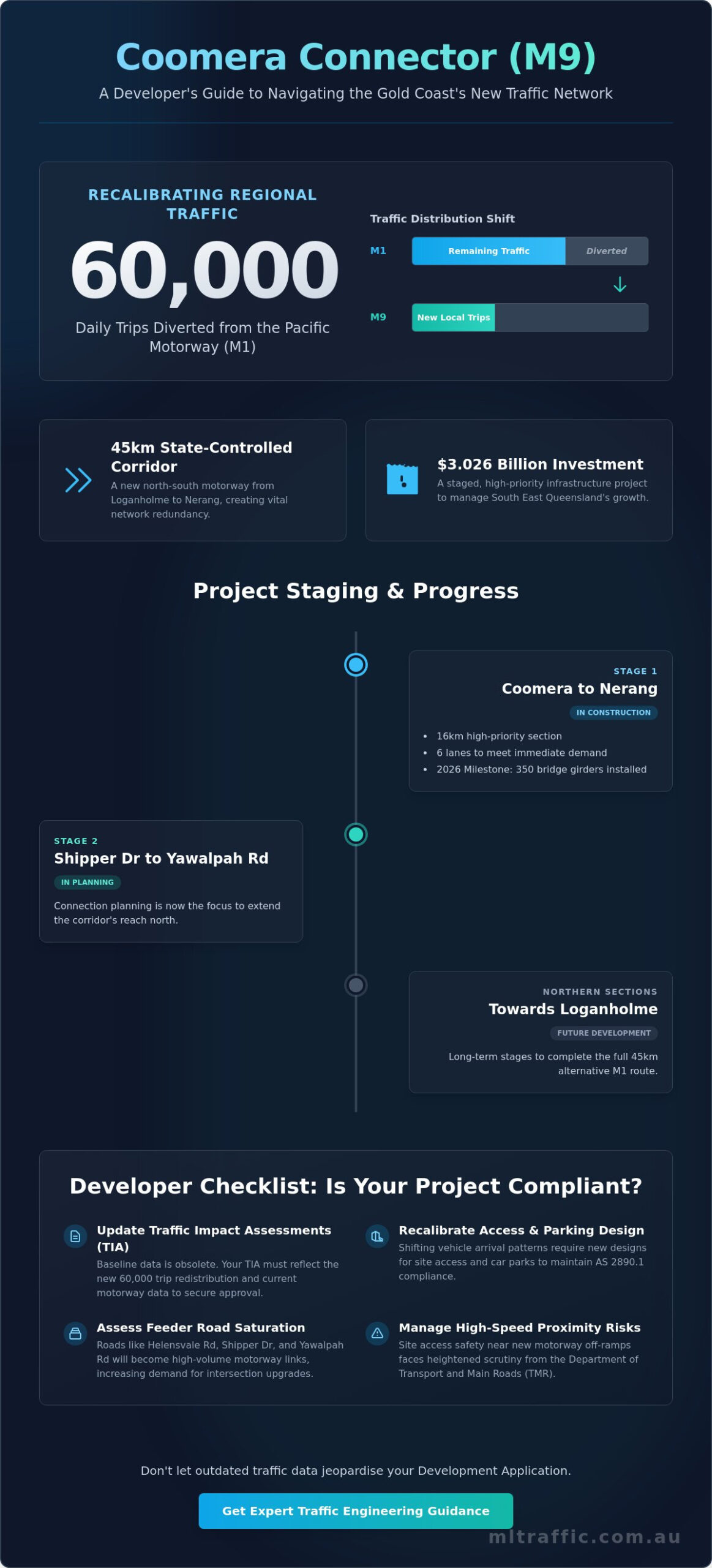
The project is delivered in stages to manage its $3.026 billion budget. Stage 1, a 16km stretch from Coomera to Nerang, is the current priority. By 2026, construction milestones include the installation of 350 bridge girders for the Coomera River crossing. Stage 1 Central provides 6 lanes to meet immediate high-growth traffic demands. Stage 2 planning now focuses on the Shipper Drive to Yawalpah Road connection, while northern stages toward Loganholme remain in long-term development.
The M1 vs. The M9: Network Redundancy
The M9 creates a “backbone” for local traffic, effectively separating short trips from long-haul M1 flow. The Coomera Connector Second M1 is expected to remove up to 60,000 local daily trips from the M1. This provides essential network redundancy, preventing regional paralysis during M1 incidents. It also redistributes heavy vehicle traffic. Developers should note this changes the load on roads like Helensvale Road and Shipper Drive, which now function as critical motorway links.
The state-controlled status of the M9 means any development within the gazetted corridor’s proximity faces heightened scrutiny. This isn’t just about road noise or visual impact. It’s about how your site’s traffic interacts with a high-speed motorway environment. The Department of Transport and Main Roads (TMR) maintains strict oversight on how new developments connect to these corridors. Understanding the technical nuances of the M9 designation is the first step in ensuring your project remains viable as the network evolves.
Traffic Flow Implications for Surrounding Infrastructure
The Coomera Connector Second M1 fundamentally alters the hierarchy of the Gold Coast road network. By removing up to 60,000 local daily trips from the M1 Pacific Motorway, the project forces a massive redistribution of traffic across the surrounding arterial and sub-arterial network. This shift isn’t merely a reduction in volume on one road; it’s a structural change in how vehicles move between Logan and the Gold Coast. As the M9 becomes the preferred local transit route, peak-hour directional flows will mirror the new motorway’s access points rather than traditional M1 interchanges. According to the Official Coomera Connector Project Page, this project is essential for managing the regional growth that currently chokes the existing motorway.
Feeder roads such as Helensvale Road, Yawalpah Road, and Shipper Drive will bear the weight of this redistribution. These corridors will transition from local access ways into high-volume conduits for motorway traffic. Developers must prepare for increased demand for intersection upgrades at every key connector touchpoint. If your project sits near these interchanges, the baseline traffic data you used two years ago is likely obsolete. Assessing the current capacity of these feeder roads is a critical step for any upcoming Development Application.
Feeder Road Capacity and Saturation
Local roads will soon handle the “last mile” transition from a high-speed motorway environment to urban site access. This transition creates potential for saturation at existing roundabouts and signalised intersections. Council mandates for infrastructure upgrades are becoming more frequent as a condition of development approval. It’s now necessary to perform a detailed Intersection Analysis for any new projects near these interchanges to prove that the local network can sustain the projected arrival patterns. If you’re unsure how these changes affect your specific site, consulting with a senior traffic engineer can clarify your obligations.
Heavy Vehicle and Freight Movement
Industrial developments will see the most significant impact on their operational logistics. Truck turning movements will shift as freight routes adapt to the M9 corridor, requiring a re-evaluation of high-capacity access points and internal site queuing. The M9 establishes a new freight baseline for 2026 logistics by creating a dedicated bypass for local heavy vehicle movements. This shift requires meticulous planning to ensure that industrial site entries can handle the modified approach angles and increased frequency of heavy vehicle arrivals without compromising local safety or network efficiency.
Impact on Development Applications and Traffic Impact Assessments
The progression of the Coomera Connector Second M1 necessitates a fundamental shift in how developers approach their planning submissions. Traditional traffic models based on pre-2024 data are now insufficient for securing approval. The Queensland Government’s re-gazettal of the corridor on June 27, 2025, formally established the boundary protections that every new development must respect. Any project within the vicinity of this 45km corridor must now demonstrate how it integrates with the state’s updated regional traffic network. This requirement extends beyond simple volume counts; it involves a comprehensive evaluation of how a site interacts with a high-speed motorway environment.
State-controlled road overlays and land resumption potential are primary concerns for sites fronting the corridor. Developers must account for noise and environmental factors within their Statement of Environmental Effects to meet the standards set by the project’s Public Environment Report. Failure to address these corridor protection overlays can lead to significant delays or the total rejection of a Development Application. Ensuring your project aligns with the $3.026 billion infrastructure investment is essential for maintaining site viability.
Recalibrating the Traffic Impact Assessment (TIA)
2024 traffic data is no longer a reliable baseline for 2026 Development Applications. The redistribution of 60,000 daily trips fundamentally alters the background traffic growth projections used in a Traffic Impact Assessment. Your TIA must now incorporate the M9 project milestones into a 10-year growth forecast. Council assessments are increasingly focused on “rat-running” through local streets as drivers seek shortcuts to reach the connector. You must prove your development won’t exacerbate these shortcutting patterns or compromise the efficiency of the arterial network.
Access Management and Sight Distance
Managing the transition between high-speed arterial flow and private site entry requires precise engineering. Driveway locations that were acceptable under previous road classifications may now fail safety audits due to their proximity to motorway off-ramps. It’s critical to perform a rigorous Sight Distance Assessment to ensure compliance with TMR standards. We focus on the following technical requirements for site access:
- Compliance with state-controlled road access policies for all sites fronting the M9.
- Adequate deceleration lengths for vehicles entering the site from high-volume feeder roads.
- Verification of safe gap acceptance at unsignalised site entries near interchanges.
- Alignment of internal queuing areas to prevent tail-backs onto the public road network.
The technical requirements for access have tightened as the project moves toward its late 2025 progressive opening. Every driveway ramp grade and intersection angle must be scrutinised to ensure it can handle the modified traffic patterns without creating a safety hazard. Proactive engagement with these requirements is the only way to ensure a seamless approval process.
Navigating Car Park Design and Access Compliance Near Major Corridors
The Coomera Connector Second M1 doesn’t just change the road outside; it dictates the functional requirements of everything inside your site boundary. Increased traffic frequency on feeder roads means your internal site layout must accommodate modified vehicle arrival patterns to prevent queuing onto public land. Council scrutiny regarding off-street parking has intensified as the regional network evolves. Ensuring your site remains operational requires strict adherence to national standards for parking and maneuvering. We focus on ensuring your layout handles these new arrival rates without compromising safety or network efficiency.
Swept Path Analysis for Complex Sites
Simulating heavy vehicle access is now a mandatory component of most Development Applications near the corridor. We use AutoTURN software to perform a detailed Swept Path Analysis for sites interacting with M9 feeder traffic. This process proves that delivery vehicles and waste trucks can maneuver safely without causing bottlenecks at your site entry. In 2026, a certified Swept Path Analysis is the gold standard for council approval because it provides visual, data-driven proof of a site’s operational safety. Proving that an 8.8m Medium Rigid Vehicle (MRV) can enter and exit in a forward motion is often the difference between a quick approval and a costly Request for Information (RFI).
Compliant Car Park Design
Commercial developments near major corridors face higher traffic turnover, which puts pressure on driveway ramps and internal circulation. You must verify that your design meets both AS 2890.1 for light vehicles and AS 2890.2 for commercial vehicles. Adjusting ramp grades and driveway widths is essential to handle the increased frequency of arrivals from the Coomera Connector Second M1. Improved regional connectivity also shifts your parking requirements. A comprehensive Car Parking Demand Assessment evaluates whether your proposed provision matches the actual needs of a more accessible site.
Ensuring your internal layout is both compliant and efficient is a technical necessity in high-growth corridors. If you require professional verification of your site’s functionality, our team can review your car park design to ensure it meets all regulatory benchmarks and avoids unnecessary council delays.
Professional Traffic Engineering for Major Infrastructure Adjacencies
Developing property within a state-controlled corridor like the Coomera Connector Second M1 requires more than standard civil design. It demands a sophisticated understanding of how the Department of Transport and Main Roads (TMR) evaluates site access and impact. ML Traffic Engineers Australia provides the technical expertise necessary to navigate these high-stakes requirements. Our approach is based on multi-decade professional longevity and a track record of successful approvals in complex urban environments. We understand the bureaucratic requirements of the $3.026 billion Stage 1 project and how they influence local development conditions.
Why Senior Expertise Matters
We operate with a “no-gatekeepers” philosophy. This means you have direct access to senior principals who perform the actual technical work. Unlike larger firms where junior staff handle the data while principals only sign the cover page, ML Traffic Engineers Australia ensures personnel continuity. The expert who initiates your project is the one performing the Vehicle Swept Path Analysis and drafting the TIA Report. This accountability ensures that the technical nuances of your site are never lost in translation. Visit our About page to learn about our 15+ years of experience in the Australian market.
Securing DA Approval in a Changing Landscape
The shift in traffic volumes caused by the M9 necessitates meticulous reporting that anticipates council objections before they are raised. We provide results-oriented assessments that address specific regional challenges, such as the redistribution of heavy vehicle freight. Our reports are designed to be authoritative and compliant with national regulatory standards. ML Traffic Engineers Australia offers a comprehensive suite of technical services to support your application:
- Detailed Intersection Analysis for sites near new interchanges and feeder roads.
- Sight Distance Assessments to ensure driveway safety on high-volume corridors.
- Traffic Guidance Schemes (TGS) to support safe construction phases near the Coomera Connector Second M1.
- Waste Management Plans and Car Park Design that meet AS 2890.1 and AS 2890.2 requirements.
Navigating the requirements of a major infrastructure project shouldn’t be a barrier to your development’s success. We apply national expertise to the specific challenges of the Gold Coast growth corridor, ensuring your project remains viable as the network evolves. Contact ML Traffic Engineers Australia for a comprehensive site assessment that ensures your project meets every compliance benchmark and avoids unnecessary council delays.
Securing Your Development in the M9 Corridor
The Coomera Connector Second M1 represents a fundamental shift in the Gold Coast road network that requires immediate strategy recalibration for all nearby projects. Successfully navigating this transition involves more than just updating traffic counts; it requires a proactive approach to site access and internal functionality. As the region evolves, maintaining strict compliance with state-controlled road standards and national parking requirements is essential for securing your Development Application and ensuring long-term site viability.
ML Traffic Engineers Australia provides the technical certainty needed to meet these heightened expectations. We offer 15+ years of specialist traffic engineering experience and guarantee you direct access to senior principals on every project. Our comprehensive knowledge of Australian Standards AS 2890 ensures your site remains compliant and functional in this high-growth environment. We handle the technical complexities of Swept Path Analysis and TIA reporting so you can focus on project delivery.
Contact ML Traffic Engineers Australia for a Professional Traffic Impact Assessment and secure your project’s approval with authoritative technical data. We look forward to ensuring your development’s success.
Frequently Asked Questions
What is the Coomera Connector (Second M1) and why is it being built?
The Coomera Connector is a 45km state-controlled north-south road corridor designated as the M9. It’s being built to provide a critical alternative to the Pacific Motorway (M1) and relieve regional congestion. The project aims to remove up to 60,000 local daily trips from the M1, improving travel time reliability for residents between Loganholme and Nerang.
Is the Coomera Connector a toll road?
No, the Coomera Connector is a non-tolled motorway. The Australian and Queensland governments have jointly funded the $3.026 billion Stage 1 project to ensure it remains a free alternative for local traffic. This funding model supports the goal of diverting short-distance trips away from the main M1 corridor without adding financial burdens to commuters.
How will the Coomera Connector affect existing property developments?
Existing and future developments must adhere to the re-gazetted corridor boundaries established on June 27, 2025. This gazettal protects the land from new development that could interfere with the motorway’s alignment. Projects near the corridor face stricter requirements for noise mitigation, environmental offsets, and specific site access configurations to maintain the safety of the high-speed network.
When will Stage 1 of the Coomera Connector be fully open to traffic?
Stage 1 of the Coomera Connector Second M1 is expected to open progressively in sections starting from late 2025. Major construction milestones, including the installation of 350 bridge girders, are already complete as of 2026. This 16km section will provide immediate relief to the high-growth areas between Coomera and Nerang.
Does my development need a new Traffic Impact Assessment because of the M9?
Yes, most developments near the corridor require an updated Traffic Impact Assessment (TIA). The Coomera Connector Second M1 fundamentally changes the regional traffic baseline, making 2024 data obsolete for 2026 applications. Your TIA must reflect the redistributed volumes on feeder roads like Helensvale Road and Yawalpah Road to ensure your site remains compliant with current council expectations.
What is the difference between the Coomera Connector and the Pacific Motorway (M1)?
The M1 serves as the primary regional and interstate freight link. In contrast, the Coomera Connector functions as a secondary backbone for local north-south trips. By separating local traffic from long-haul freight and through-traffic, the M9 improves overall network redundancy and reduces the impact of incidents on the Pacific Motorway.
How do I ensure my site access complies with new road corridor standards?
Compliance requires a formal Sight Distance Assessment and verification of driveway ramp grades against TMR state-controlled road policies. Access points must be engineered to handle the transition from high-speed arterial flow without creating safety hazards. We use technical data to ensure your site entry meets every regulatory benchmark and avoids queuing onto public roads.
What role does a traffic engineer play in a Development Application near the M9?
A traffic engineer provides the technical evidence required to secure council and state approval. This includes performing a Vehicle Swept Path Analysis to prove site functionality and drafting a TIA Report based on the latest motorway data. We ensure your internal car park design and access points comply with AS 2890 standards while addressing the specific challenges of the new corridor.

Disclaimer
The content on www.mltraffic.com.au, including all technical articles, guides, and resources, is provided for general informational and educational purposes only. It is not intended to constitute professional advice in traffic engineering, transportation planning, development approvals, or any other technical or legal field.
While ML Traffic Engineers makes every reasonable effort to ensure the accuracy, completeness, and timeliness of the information published, we do not provide any warranties or representations (express or implied) regarding its reliability, suitability, or availability for any particular purpose. Any reliance you place on the content is strictly at your own risk.
In no event shall ML Traffic Engineers, its directors, employees, authors, or affiliates be liable for any direct, indirect, incidental, special, consequential, or punitive damages (including, without limitation, loss of profits, data, or business opportunities) arising out of or in connection with the use of, or inability to use, any information provided on this website.
The articles and guides on this site are not a substitute for engaging a qualified, registered professional traffic engineer (such as an NPER or RPEQ engineer) to assess your specific project requirements. For tailored advice, compliance assessments, or traffic engineering services, please contact a competent professional.
This disclaimer may be updated from time to time without notice. By accessing or using this website, you agree to be bound by the most current version of this disclaimer.
