
A council request for a complex traffic study is often a trigger for costly, unverified road upgrade conditions that can stall project progress. Developers across Australia frequently face significant DA delays when traffic impact concerns arise or when SIDRA modelling results appear to demand excessive infrastructure investments. It is a common challenge where technical requirements can feel like a bureaucratic barrier rather than a fair assessment of a site’s actual impact. This frustration is compounded when unexpected road-work conditions threaten the financial viability of a project before construction even begins.
This guide demonstrates how technical intersection analysis for development applications and travel time studies provide the authoritative evidence required to secure council approval. You will learn how precise data on intersection capacity and vehicle delays can protect your project from unnecessary infrastructure demands. We will outline the specific methods used to provide a clear understanding of traffic impact, ensuring your development case is supported by accurate, professional assessments that satisfy regulatory authorities. By leveraging industry-standard modelling, you can navigate the planning process with confidence and keep your project on schedule.
Key Takeaways
- Understand how intersection analysis for development applications demonstrates your project’s ability to integrate with the existing road network safely and efficiently.
- Learn how field data from travel time and delay studies is used to calibrate SIDRA modelling, ensuring your technical reports reflect actual site conditions.
- Identify strategic mitigation measures that can resolve intersection capacity issues without the need for major, high-cost road reconstruction works.
- Recognise why direct involvement from senior traffic engineering principals is critical for navigating complex council requirements and securing DA approval.
The Role of Intersection Analysis in Development Applications
Intersection analysis for development applications is the technical assessment of capacity, delay, and safety at road junctions. This process evaluates how a proposed project affects the safety and efficiency of nearby road junctions. It’s a critical component of a comprehensive Traffic Impact Assessment (TIA). Without this data, council planners cannot determine if the existing road network can absorb additional vehicle trips generated by a new site. While some developers view traffic as a minor environmental impact, intersection capacity is often the primary reason for DA refusal or the imposition of expensive infrastructure conditions.
Our team at ML Traffic Engineers provides these specialised Traffic Impact Assessment (TIA) Reports to ensure regulatory compliance. We focus on delivering precise data that reflects the technical realities of the Australian road network. Senior principals oversee every technical assessment, ensuring that the modelling stands up to rigorous council scrutiny.
Why Councils Require Detailed Intersection Data
Local government authorities and state road agencies require detailed intersection data for several specific reasons:
- Prevention of gridlock: Planners must ensure that new developments don’t trigger systemic failure in growing urban and regional centres.
- Pedestrian safety: Detailed analysis identifies potential conflicts at high-volume crossing points, protecting vulnerable road users.
- Infrastructure funding: The data helps councils identify the need for developer-funded infrastructure upgrades to maintain network stability.
- Regulatory alignment: All assessments must adhere to Australian Standards (AS 2890) and relevant state guidelines to gain approval.
Key Metrics: Level of Service (LoS) and Degree of Saturation
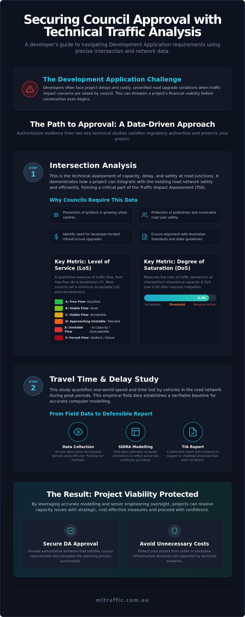
Two primary metrics dictate the success of a DA: Level of Service and Degree of Saturation. These figures provide a quantitative basis for the “pass or fail” status of a development proposal. The Level of Service (LOS) is a qualitative measure used to describe operational conditions within a traffic stream. It ranges from LoS A, representing free-flow conditions, to LoS F, which indicates a complete breakdown of the traffic flow. Most councils set a minimum acceptable LoS that a developer must maintain post-completion.
The Degree of Saturation (DoS) is equally vital. It measures the ratio of traffic demand to the theoretical capacity of the junction. A DoS exceeding 0.90 typically indicates that an intersection is nearing its limit, often triggering a requirement for mitigation measures. We use these metrics to prove a site’s viability. By providing accurate data, we protect developers from unfair infrastructure demands that aren’t supported by the technical evidence.
Conducting a Travel Time and Delay Study for Road Networks
A travel time and delay study is an empirical exercise that quantifies the actual speed and time lost by vehicles along a defined corridor. While theoretical models provide a starting point, this field data establishes the “real-world” baseline that computer simulations must replicate. We typically conduct these studies during morning and afternoon peak periods to capture the network under maximum stress. By observing these “worst-case” scenarios, engineers can pinpoint specific bottlenecks that a proposed project might exacerbate. Without this groundwork, a development’s impact remains speculative, often leading to friction with local authorities.
Accurate field data is the foundation of any defensible Traffic Impact Assessment (TIA) report. It transforms abstract traffic counts into a tangible map of network performance. This level of detail is essential when conducting an intersection analysis for development applications, as it provides the evidence needed to challenge or support proposed road-work conditions.
Step-by-Step Methodology for Data Collection
The collection process begins by identifying the study area and established timing points along the road network. We utilise the “floating car method,” where a driver traverses the route while attempting to match the average speed of the traffic stream. Modern assessments supplement this with high-precision GPS-based data logging to ensure centimetre-perfect accuracy. During these runs, we record the specific causes of every delay. These include signal timing inefficiencies, excessive queuing at roundabouts, or heavy pedestrian activity at mid-block crossings. This granular approach ensures that the eventual modelling reflects the unique characteristics of the local Australian road environment.
Analysing the Data: Mean Travel Time vs. Geometric Delay
Once the data is collected, we calculate the mean travel time, which represents the average duration required to traverse the network during peak periods. We then distinguish between different types of delay to understand the root cause of congestion. Stopped delay refers to time lost at red lights or while waiting for a gap in traffic. Conversely, geometric delay is the time lost due to the physical layout of the road, such as slowing down for a tight turn or navigating a steep gradient. By separating these from mid-block delays caused by general congestion, we can provide a clearer picture of how an intersection analysis for development applications should be structured. This clarity allows for more targeted mitigation strategies, focusing on the specific movements that cause the most significant impact on travel times.
From Field Data to SIDRA Modelling: Technical Integration
SIDRA INTERSECTION 11 remains the industry-standard software for intersection analysis in Australia. It provides the mathematical framework required to simulate complex traffic movements and predict delays with high precision. However, a software model is a theoretical construct that requires grounding in reality. We integrate the raw field data collected during travel time and delay studies to “calibrate” the software. This process is essential when conducting an intersection analysis for development applications, as it ensures the simulation reflects the specific operational characteristics of the local road network. You can learn more about our specialised traffic engineering services and how we apply these technical tools to support your project objectives.
The Importance of Model Calibration
Model calibration is the critical process of adjusting software parameters so the output matches real-world observations. A model is only as reliable as the data supporting it. We focus on fine-tuning specific variables such as “gap acceptance” and “saturation flow” to align with local Australian driving conditions and Austroads standards. For instance, driver behaviour in a high-density urban centre differs significantly from regional settings. We verify that the model accurately replicates the queues and delays recorded in our field surveys. This rigorous calibration is a vital step in any intersection analysis for development applications. It prevents the software from overestimating or underestimating capacity. Accurate modelling protects developers from being forced into project-killing road upgrade requirements based on flawed or generic data.
Predicting Future Traffic Impacts
Once calibrated, the model serves as a robust platform for testing “What If” scenarios over a 10-year horizon. We don’t just look at the development in isolation. We factor in “background growth” derived from other nearby approved developments and long-term strategic planning data. The software simulates the “post-development” scenario by layering the new site’s generated traffic onto the existing network. This process identifies the exact point where an intersection reaches its capacity limit. Our senior principals use these results to determine if the proposed development will push the Degree of Saturation (DoS) beyond acceptable thresholds. This forward-looking analysis allows us to address potential issues before they become grounds for a council refusal. It provides the technical certainty needed to negotiate road-work conditions with planning authorities.
Mitigation Strategies: Resolving Intersection Deficiencies
If the technical intersection analysis for development applications indicates that a junction will exceed its capacity, the developer must propose viable mitigation strategies. Council planners rarely accept a proposal that degrades the existing Level of Service (LoS) without a clear plan for rectification. Minor operational adjustments can often resolve these deficiencies. This prevents the need for major, high-cost road reconstructions that can jeopardise project budgets. Proactive mitigation planning demonstrates a commitment to network safety and significantly speeds up the DA approval process. Engineers work closely with councils to find a balance between development needs and public infrastructure requirements.
Our senior principals specialise in identifying these strategic fixes early in the planning phase. By addressing potential failures before the DA is lodged, we provide the technical certainty needed to negotiate road-work conditions. If you require a detailed assessment to support your project, contact our team for a professional Intersection Analysis tailored to your specific site requirements.
Common Physical and Operational Upgrades
Physical and operational upgrades are the first line of defence against network failure. We focus on cost-effective solutions that maximise existing road assets. Common interventions include:
- Dedicated turn lanes: Adding short auxiliary lanes for left or right turns removes stationary vehicles from through-traffic. This simple change immediately reduces mid-block delay and improves safety for all road users.
- Traffic signal optimisation: We adjust signal phasing and offsets to synchronise flow across multiple junctions. This reduces the number of stops and minimises the overall travel time through the corridor.
- Roundabouts vs. Signalised Intersections: We conduct a rigorous cost-benefit analysis to determine the best treatment. Roundabouts often offer better continuous flow for lower volumes, while signals are necessary for complex, high-volume junctions with heavy pedestrian activity.
Demand Management and Access Design
Demand management focuses on how vehicles enter and exit the site. Strategic access design can bypass congested intersections entirely by relocating site access points to less burdened road segments. This reduces the additional load on the primary junction and maintains the integrity of the local network. Implementing “Left-In, Left-Out” (LILO) restrictions is another proven method to reduce high-risk turning movements across multiple lanes of traffic.
These restrictions must be supported by practical design. Accurate Swept Path Analysis is essential here to ensure that restricted access points remain functional for heavy vehicles, emergency services, and waste collection. By integrating these design elements into the initial TIA, we help developers avoid the high costs of unexpected road upgrades demanded by the council later in the process.
Choosing the Right Traffic Consultant for Your DA
Technical intersection analysis for development applications requires more than just access to modelling software. It demands a sophisticated blend of high-level mathematical precision and practical field experience. Many large firms delegate this complex technical work to junior staff, which can lead to errors that council planners quickly identify during the review process. At ML Traffic Engineers, we ensure that senior principals handle the technical heavy lifting. This direct involvement is critical for navigating the bureaucratic requirements of Australian planning authorities. We prioritise strict compliance with Australian Standards (AS 2890) and local council Development Control Plans (DCPs) to ensure your report is defensible. Contact our senior engineers to discuss your intersection study requirements and secure an authoritative assessment for your project.
The ML Traffic Engineers Advantage
With over 15 years of specialised experience, our firm understands the nuances of the Australian DA process. We have a proven track record in negotiating fair infrastructure outcomes, preventing developers from being burdened with unnecessary road-work conditions. Our personnel continuity promise means the expert who initiates your project is the same one performing the technical analysis. This accountability ensures that the data presented to the council is accurate and meticulously prepared. We have successfully managed intersection analysis for development applications across a diverse range of project types. These include residential subdivisions, retail centres, healthcare facilities, and complex industrial sites. This deep-seated expertise allows us to anticipate council objections and address them before they cause significant delays.
Next Steps for Your Development Application
The planning process moves more efficiently when technical issues are identified early. To begin, gather your existing site plans and proposed yield data for an initial professional review. We recommend commissioning a preliminary traffic impact assessment to identify potential deal-breakers before you lodge your application. Engaging an expert early allows for the strategic management of council expectations regarding travel time and delay. This proactive approach ensures that your development case is supported by robust traffic data from the outset. By identifying necessary mitigation measures during the design phase, you can avoid the high costs of unexpected road upgrades. Our team provides the technical certainty needed to move your project forward with confidence.
Securing Your Development Approval with Expert Traffic Data
Precise intersection analysis for development applications is the most effective way to manage council expectations and mitigate the risk of project-killing road upgrade conditions. By grounding SIDRA modelling in real-world travel time and delay data, we provide a defensible technical case that stands up to rigorous planning scrutiny. This evidence-based approach ensures that any proposed mitigation measures are proportionate to the site’s actual impact, protecting your project budget from unverified infrastructure demands.
ML Traffic Engineers offers over 15 years of specialised Australian consultancy expertise. We ensure comprehensive compliance with Australian Standards and provide direct access to senior principals for every technical assessment. This level of accountability is essential for navigating complex regulatory environments and achieving successful project outcomes. We’re ready to help you navigate the planning process and keep your development on track.
Get an authoritative Traffic Impact Assessment for your DA
Frequently Asked Questions
What is a travel time and delay study in traffic engineering?
A travel time and delay study is an empirical field assessment that measures the actual time taken for vehicles to traverse a specific route. It identifies the exact locations, durations, and causes of traffic stops. This data provides the “real-world” baseline required to calibrate computerised models, ensuring that the technical report reflects actual site conditions rather than theoretical software defaults.
How long does an intersection analysis take for a DA?
A standard analysis typically requires two to four weeks to complete. This timeframe includes the coordination of peak-hour field surveys, data processing, SIDRA modelling, and the final report drafting. More complex projects involving multiple junctions or extensive council negotiations may extend this period to ensure all technical requirements are met.
Will the council accept SIDRA modelling without field data?
Most Australian councils will not accept modelling that lacks local calibration. Using default software values without supporting field data often results in inaccurate predictions of queue lengths and delays. Authorities require empirical evidence from travel time studies to verify that the model accurately represents the current performance of the local road network.
Can I do my own traffic counts for a development application?
No, councils require data collected by qualified professionals using industry-standard methodologies. Technical assessments like an intersection analysis for development applications must be defensible and accurate. Self-collected data lacks the necessary certification and methodology required to survive the rigorous scrutiny of a formal DA review process.
What happens if the intersection analysis shows a “Level of Service F”?
A Level of Service (LoS) F indicates that the intersection has reached its capacity and traffic flow has broken down. In this scenario, the developer must propose specific mitigation strategies, such as lane widening or signal optimisation, to restore the junction to an acceptable operating level. Failure to provide a viable mitigation plan usually leads to the refusal of the application.
How much does a travel time and delay study cost?
The cost depends on the number of intersections under review and the complexity of the corridor. Fees reflect the specialised technical expertise, field equipment, and senior-level analysis required to produce a compliant report. We recommend contacting our senior principals directly to obtain a specific fee proposal tailored to your project yield and location.
Is intersection analysis required for residential subdivisions?
Yes, intersection analysis is often a mandatory requirement for residential subdivisions that generate significant new vehicle trips. The council must ensure that the additional traffic from new residents won’t cause existing junctions to fail. A formal intersection analysis for development applications proves the network can absorb the increased load without compromising safety or efficiency.
Do I need a separate study for construction traffic delays?
Councils often require a specific assessment of construction-related impacts as part of a Traffic Management Plan. This study addresses temporary delays caused by heavy vehicle movements and site access during the build phase. It ensures that construction activities don’t cause systemic gridlock or safety hazards in the surrounding neighbourhood while the project is underway.

Disclaimer
The content on www.mltraffic.com.au, including all technical articles, guides, and resources, is provided for general informational and educational purposes only. It is not intended to constitute professional advice in traffic engineering, transportation planning, development approvals, or any other technical or legal field.
While ML Traffic Engineers makes every reasonable effort to ensure the accuracy, completeness, and timeliness of the information published, we do not provide any warranties or representations (express or implied) regarding its reliability, suitability, or availability for any particular purpose. Any reliance you place on the content is strictly at your own risk.
In no event shall ML Traffic Engineers, its directors, employees, authors, or affiliates be liable for any direct, indirect, incidental, special, consequential, or punitive damages (including, without limitation, loss of profits, data, or business opportunities) arising out of or in connection with the use of, or inability to use, any information provided on this website.
The articles and guides on this site are not a substitute for engaging a qualified, registered professional traffic engineer (such as an NPER or RPEQ engineer) to assess your specific project requirements. For tailored advice, compliance assessments, or traffic engineering services, please contact a competent professional.
This disclaimer may be updated from time to time without notice. By accessing or using this website, you agree to be bound by the most current version of this disclaimer.
