

A single structured parking space can cost up to $60,000 to construct, yet many developers are still forced into expensive basement excavations for spots that may never be used. If you’ve faced a DA rejection due to “insufficient” parking, you likely need to know how to calculate parking credits for public transport access to justify a more efficient design. It’s a common frustration to see site yield sacrificed for unnecessary levels of parking when high-quality transit options are right on your doorstep, especially when conflicting LGA guidelines make compliance feel like a moving target.
This guide provides a technical roadmap to mastering these calculations, from navigating the Green Star v1.1 rating tool to local council credit frameworks. You’ll learn how to produce a data-driven Car Parking Demand Assessment that satisfies regulatory bodies while significantly reducing your construction footprint. We’ll examine the specific methodologies required to turn accessibility into a tangible reduction in required bays, ensuring your development remains both compliant and commercially viable. By the end of this article, you’ll have the expertise needed to optimise your site yield through professional traffic engineering principles.
Key Takeaways
- Understand how to calculate parking credits for public transport access to reduce basement excavation requirements and optimise your development’s total site yield.
- Learn to apply the Green Star and GBCA frameworks by accurately identifying transport nodes within specified 400m and 800m walking catchments.
- Discover how a first principles approach and merit assessment pathway can justify parking provisions that sit below standard local government DCP requirements.
- Master the technical process of using GTFS data to map train, bus, and ferry frequencies for a compliant Car Parking Demand Assessment.
- Recognise why professional Traffic Engineer certification is essential for securing Council approval and ensuring technical accountability for parking credit claims.
Understanding Parking Credits and Transport Accessibility
Parking credits represent a formal reduction in the number of on-site car spaces required for a new development. These reductions aren’t arbitrary. They’re based on the site’s proximity to high-frequency transit nodes like train stations, bus interchanges, or Park and Ride Schemes. Understanding how to calculate parking credits for public transport access is critical for developers who want to minimise construction costs while maintaining strict regulatory compliance.
Australian planning relies on the Integrated Transport and Land Use philosophy. This approach assumes that as public transport accessibility increases, the demand for private vehicle ownership and usage decreases. Consequently, planners can justify lower parking rates without negatively impacting local traffic flow or street parking availability. It’s a data-driven strategy that aligns urban density with existing infrastructure capacity.
Developers must distinguish between statutory requirements and merit-based reductions. Statutory requirements are fixed numbers found in a local Council’s Development Control Plan (DCP). Merit-based reductions require a professional Car Parking Demand Assessment to prove that the actual demand is lower than the code suggests. There are two primary frameworks to navigate: the Green Star credit system for sustainability certification and the specific parking concessions outlined by local government authorities.
The Economic Impact of Parking Reductions
Reducing a single level of basement parking can save hundreds of thousands of dollars in excavation and structural costs. With structured parking costs reaching up to $60,000 per space, every credit secured directly improves project feasibility. Beyond capital savings, reducing the parking footprint often allows for a higher Floor Space Index (FSI). This means more saleable or leasable area on the same site. Leading urban centres now encourage “unbundling” parking, where spaces are sold or leased separately from the primary unit, further incentivising transit use.
Regulatory Frameworks for Parking Credits
State Environmental Planning Policies (SEPPs) play a pivotal role in transport-oriented development by providing overarching rules that can override local restrictions. However, the local DCP remains the primary document for specifying credit eligibility. To navigate these requirements, developers should refer to the Traffic Impact Assessment: The Definitive Guide for Australian Developers. This foundational document explains how various planning instruments interact to determine the final parking provision. Professional certification is usually mandatory to ensure these calculations meet the rigorous standards expected by Council planners.
The Green Star Methodology: Access by Public Transport
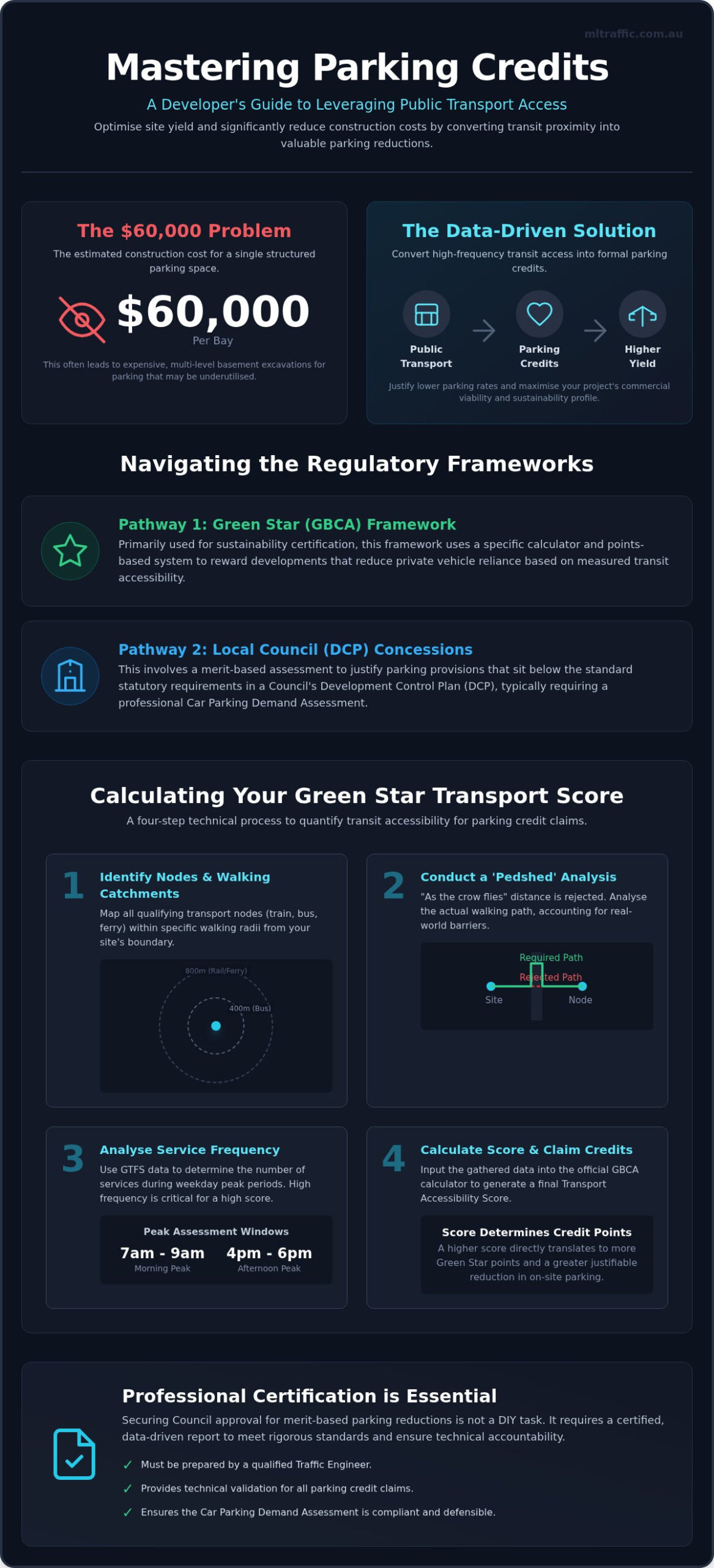
The Green Building Council of Australia (GBCA) provides a specific calculator to quantify the sustainability of a site’s location relative to transit. Its primary purpose is to incentivise developments that reduce private vehicle reliance. Mastering how to calculate parking credits for public transport access within this framework requires a rigorous four-step methodology that moves from simple mapping to complex frequency analysis.
The technical process begins by identifying all transport nodes within a specific walking catchment. Typically, this involves a 400-metre radius for bus stops and an 800-metre radius for rail or ferry terminals. Once these nodes are identified, you must determine the service frequency during peak periods, specifically between 7 am and 9 am and 4 pm and 6 pm. This data is then fed into the GBCA formula to generate a transport accessibility score. Finally, this score is mapped to available credit points within the Green Star framework, which directly informs the allowable reduction in on-site parking provisions.
Defining Walking Catchments and Pedshed Analysis
Radial distance, often called “as the crow flies,” is generally rejected by Australian Councils and the GBCA. It fails to account for the reality of the urban environment. Instead, a “pedshed” analysis is required to identify actual walking paths. This method accounts for physical barriers such as major arterial roads, existing rail lines, or steep topography that might lengthen a commute. A professional Car Parking Demand Assessment will always use pedshed mapping to ensure the data survives Council scrutiny.
Service Frequency: The “High Frequency” Benchmark
A service is only considered “high frequency” in the Australian context if it maintains a reliable headway that reduces commuter wait times. You must use current timetable data to calculate average wait times across the morning and afternoon peaks. Different modes carry different weightings in the calculation. Heavy rail and metro services generally provide higher credit values than standard bus routes due to their higher capacity and permanence. While some international institutions use a Transit/Parking Reimbursement Program to manage demand, Australian developers rely on these frequency scores to justify stripping back expensive basement levels during the design phase. Accurate data collection at this stage prevents the GBCA from rejecting your credit claims during the formal certification process.
Council DA Requirements: Justifying Parking Reductions
When a development proposal fails to meet the prescriptive minimums of a local Development Control Plan (DCP), developers must pursue a Merit Assessment pathway. This process moves beyond rigid tables and instead focuses on the actual site context. To succeed, you must demonstrate how to calculate parking credits for public transport access using a first principles approach. This involves proving that the specific characteristics of your site, such as its proximity to high-frequency rail or bus interchanges, result in a lower parking demand than the generic figures found in Council codes.
One of the most effective tools in this argument is the use of Australian Bureau of Statistics (ABS) census data. By examining car ownership rates in established transit-rich precincts adjacent to your site, you can provide a realistic forecast of resident or tenant behaviour. This data-driven strategy mirrors international best practices, such as the Perfect Fit Parking Initiative, which advocates for matching parking supply to actual demand rather than arbitrary standards. Comparing Council’s blanket minimums with empirical peak demand data allows for a robust justification of parking reductions during the DA process.
The Role of the Car Parking Demand Assessment
A standard Traffic Impact Assessment (TIA) often lacks the granular detail required to secure significant parking credits. Instead, a comprehensive Car Parking Demand Assessment is essential. This specialised report includes survey data from comparable “proxy” sites and a detailed analysis of transport accessibility. When presenting an Access Score to a Council planning officer, the report must clearly articulate how the site’s unique location diminishes the need for on-site bays. Senior traffic engineers use these assessments to provide the technical accountability Councils require before they will deviate from their standard DCP requirements.
Green Travel Plans (GTP) as a Credit Supplement
A Green Travel Plan functions as a formal commitment to sustainable transport, often serving as the final piece of evidence needed to “secure” a parking credit. Councils are more likely to approve reductions when the developer provides tangible alternatives to private vehicle use. Common measures within a GTP include the provision of on-site car-share pods, significant bike parking upgrades, and high-quality end-of-trip facilities. Once approved, these plans are typically formalised through the Conditions of Consent, making them legally binding documents that ensure the development operates as a low-impact, transit-oriented site.
Step-by-Step: Calculating Your Site’s Transport Score
Gathering technical data is the first priority for any developer seeking a reduction in required parking bays. To understand how to calculate parking credits for public transport access, you must start with General Transit Feed Specification (GTFS) data. This format provides a machine-readable record of every scheduled service across Australian networks. It’s significantly more reliable than manual timetable checks because it accounts for route variations, actual stop locations, and service headways. You’ll need to map every train station, bus stop, and ferry terminal within your site’s verified pedshed to build an accurate accessibility profile.
Data Collection and Tools
Most Australian states provide open-access portals for transport data, such as Open Data by Transport for NSW or Data VIC. Using Geographic Information Systems (GIS) software allows you to map precise walking routes that account for physical barriers rather than using radial distances. It’s essential to use data from the current calendar year. If your DA is future-dated, Council planners will scrutinise the assessment for any scheduled infrastructure upgrades that might alter the final frequency scores before the building is occupied.
The Calculation Formula
The Service Index is a formulaic approach to frequency, typically calculated as services per hour during peak periods. For sites with multiple transport modes, such as a bus-to-rail interchange, you must weight each service correctly. A heavy rail station with 10-minute headways provides a much higher credit value than a bus stop with half-hourly services. These figures must also align with Mode Share targets set by state governments. If a precinct targets a high public transport split, your credits must reflect that specific planning objective to be considered valid by authorities.
Common Pitfalls in Credit Calculations
One frequent error is overestimating the walkability of a route. Steep topography or a lack of signalised crossings can disqualify a transport node from the catchment radius. You must also account for specific land use requirements. A retail development has different peak demand times compared to a residential tower. A high-frequency morning bus service may not justify a parking credit for a shopping centre that experiences its peak demand on Saturday afternoons. Ignoring these nuances often leads to Council rejecting the assessment during the initial review phase.
Professional sign-off is required for these reports to be accepted by local government. For expert assistance with your Car Parking Demand Assessment, contact our senior engineers directly to ensure your calculations meet all regulatory standards.
Securing Approval: Why Professional Certification Matters
Council planners frequently query “home-made” parking credit calculations submitted by developers or architects. These internal attempts often lack the technical depth or fail to account for the specific regulatory nuances of different Local Government Areas (LGAs). A Professional Traffic Engineer provides the level of accountability and expertise required to satisfy these authorities. When you know how to calculate parking credits for public transport access using industry-standard methodologies, your submission is treated as a piece of qualified evidence rather than a speculative request.
ML Traffic Engineers Australia plays a critical role during the Request for Information (RFI) stage. We proactively defend parking reductions by providing further data-driven justification when planners express doubt. This process involves integrating the credit calculation into a comprehensive Traffic Impact Assessment. By housing the parking justification within a broader traffic report, we ensure the entire transport profile of the site is considered as a unified argument for lower on-site provisions. This prevents the fragmented approach that often leads to planning delays or unnecessary basement reworks.
Expert Witness and Land and Environment Court Support
If a Council refuses a parking credit despite technical evidence, the matter may progress to an appeals process. In these instances, reports must meet the standards required for legal proceedings. Our data-driven accessibility reports are designed to hold up under scrutiny in the Land and Environment Court. Having a senior principal personally oversee the assessment ensures that the expert testimony provided is both reliable and meticulous. Senior leadership involvement is essential for navigating these complex negotiations and securing a favourable outcome for the site yield. This level of professional accountability is what distinguishes a specialised consultancy from a generalist engineering firm.
Next Steps for Your Development Application
The most effective way to avoid basement rework is to consult with a traffic engineer early in the design phase. A preliminary site transport audit can identify exactly how many credits your location is likely to attract before you commit to a specific layout. This proactive approach prevents the high cost of redesigning parking levels late in the DA process. To secure a project-specific fee proposal and ensure your development application is compliant and optimised, contact ML Traffic Engineers Australia today. Our team provides the senior-level accountability needed to turn transport accessibility into a tangible commercial advantage.
Optimise Your Site Yield with Technical Precision
Securing parking reductions is a technical exercise that requires precise data and professional accountability. By leveraging high-frequency transit nodes and current GTFS data, you can significantly lower construction overheads and improve project feasibility. Understanding how to calculate parking credits for public transport access allows you to move beyond rigid DCP minimums and justify a design that reflects actual demand. This process is essential for modern, transit-oriented developments where basement excavation costs often compromise site viability.
ML Traffic Engineers Australia provides over 15 years of experience in Australian transport planning. Every traffic report we produce receives Senior Principal oversight to ensure total accountability and compliance with AS 2890.1 and national regulatory standards. We help you navigate the complexities of Council merit assessments and Green Star frameworks with confidence. To secure the best possible outcome for your development application, Get an Expert Car Parking Demand Assessment for Your Project. Our team is ready to help you maximise your site yield while maintaining full regulatory compliance.
Frequently Asked Questions
What is the maximum parking reduction I can get for public transport access?
The maximum allowable reduction varies significantly between Local Government Areas (LGAs) and specific land-use categories. In designated transit-oriented development zones, some Councils permit a 100% reduction for residential or commercial projects. However, most urban centres typically cap merit-based reductions between 20% and 50% of the standard DCP requirement. Achieving these higher limits requires a robust Car Parking Demand Assessment to prove that the site’s accessibility justifies the lower provision.
Does a bus stop count as much as a train station for parking credits?
Train stations generally attract higher parking credits than bus stops due to their higher passenger capacity and infrastructure permanence. While a bus stop provides accessibility, its service frequency is often less reliable over the long term compared to heavy rail or metro lines. When determining how to calculate parking credits for public transport access, engineers apply different weightings based on the transit mode’s reliability and the volume of commuters it can move during peak periods.
How do I calculate the walking distance to transport for a DA?
Walking distance for a Development Application must be calculated using a “pedshed” analysis rather than a simple radial distance. This method maps the actual path a pedestrian takes along public footpaths and crossings. Most Australian Councils accept the following maximum walking distances:
- 400 metres for bus stops.
- 800 metres for high-frequency rail or ferry terminals.
You must account for physical barriers like steep gradients or major intersections that might disqualify specific nodes.
What is the “Access by Public Transport” calculator in Green Star?
The Green Star “Access by Public Transport” calculator is a technical tool used by the Green Building Council of Australia to award points based on site location. It evaluates the number of services available within a specific walking catchment during peak morning and afternoon windows. This score contributes to the project’s overall sustainability rating. As of 2024, the GBCA has restricted access to this tool for registered projects, requiring professional certification to verify the final results.
Can I use car-sharing to further reduce my parking requirements?
Car-sharing is a highly effective supplementary measure to secure further parking reductions. Councils often permit developers to swap a standard car space for a dedicated car-share pod, sometimes at a ratio of one pod replacing five or more private bays. These arrangements must be formalised within a Green Travel Plan and are often legally bound by the Conditions of Consent to ensure the long-term viability of the transport reduction.
Do I need a traffic engineer to calculate parking credits?
Engaging a qualified traffic engineer is essential for ensuring your parking credit claims are accepted by Council planners. Professional certification provides the technical accountability required for merit-based assessments. A certified Car Parking Demand Assessment carries the professional weight necessary to defend site yield optimisations during the RFI stage. Our senior principals understand how to calculate parking credits for public transport access to meet the rigorous standards of AS 2890.1 and local government planning instruments.
How does frequency of service affect the transport score?
The frequency of service is the primary driver of the transport accessibility score. High-frequency services, defined by short headways during peak periods, demonstrate that residents or tenants have a viable alternative to private vehicle use. If a station provides a service every 10 minutes, it generates a significantly higher credit value than a station with 30-minute intervals. This data is extracted from GTFS feeds to ensure the calculation reflects current operational realities.
What happens if the public transport service is upgraded after my DA is lodged?
If a public transport service is upgraded after your DA is lodged, you can submit an updated Car Parking Demand Assessment as part of a response to a Request for Information (RFI). Documented commitments to infrastructure improvements, such as a new metro line or increased bus frequencies, strengthen the argument for parking reductions. Our engineers use planned infrastructure upgrades to justify credits, provided the upgrades are confirmed by state transport authorities before the project’s completion.

Disclaimer
The content on www.mltraffic.com.au, including all technical articles, guides, and resources, is provided for general informational and educational purposes only. It is not intended to constitute professional advice in traffic engineering, transportation planning, development approvals, or any other technical or legal field.
While ML Traffic Engineers makes every reasonable effort to ensure the accuracy, completeness, and timeliness of the information published, we do not provide any warranties or representations (express or implied) regarding its reliability, suitability, or availability for any particular purpose. Any reliance you place on the content is strictly at your own risk.
In no event shall ML Traffic Engineers, its directors, employees, authors, or affiliates be liable for any direct, indirect, incidental, special, consequential, or punitive damages (including, without limitation, loss of profits, data, or business opportunities) arising out of or in connection with the use of, or inability to use, any information provided on this website.
The articles and guides on this site are not a substitute for engaging a qualified, registered professional traffic engineer (such as an NPER or RPEQ engineer) to assess your specific project requirements. For tailored advice, compliance assessments, or traffic engineering services, please contact a competent professional.
This disclaimer may be updated from time to time without notice. By accessing or using this website, you agree to be bound by the most current version of this disclaimer.
