

What if a single overlooked vehicle clearance could derail your entire construction schedule? For many Australian developers, the transition from planning to construction reveals a costly disconnect where 2D traffic reports fail to account for the three-dimensional complexities of a modern site. This often results in low-hanging services or structural beams blocking essential delivery access, leading to expensive rework and delayed Council sign-offs.
integrating traffic design with BIM models provides a solution by embedding transport planning directly into the project’s digital architecture. This methodology transforms traffic engineering from a static compliance check into a dynamic layer of clash detection. By identifying accessibility conflicts early, project teams can ensure seamless coordination between vehicle movements and structural elements.
In this guide, we outline how BIM-integrated workflows streamline the DA process and meet modern Australian Standards. Discover how a digital-first approach prevents site clashes and reduces the cycle of information requests from assessing officers.
Key Takeaways
- Modern Australian developments require more than static 2D reports; transitioning to a 3D environment ensures traffic data is a dynamic part of the project lifecycle.
- Learn how integrating traffic design with BIM models allows for real-time clash detection between vehicle envelopes and structural elements like columns or low-hanging services.
- Identify and resolve vehicle clearance issues early in the design phase to prevent expensive variation claims and structural rework during the construction stage.
- Streamline Council DA processes and reduce RFI cycles by providing high-fidelity 3D visibility cones and precise digital compliance with AS 2890 standards.
- Establish a robust Traffic Engineering BIM Execution Plan (BEP) to ensure seamless data exchange and maintain senior-level accountability throughout the project.
The Evolution of Traffic Engineering: From 2D Reports to BIM Integration
The traditional 2D Traffic Impact Assessment (TIA) is increasingly insufficient for the demands of complex Australian development sites. For decades, traffic engineering relied on static plans that isolated vehicle movements from the three-dimensional reality of the built environment. This disconnect often resulted in design clashes that weren’t identified until construction was underway. Modern project delivery now necessitates integrating traffic design with BIM models to ensure that transport data and architectural geometry exist in a single, federated source of truth. It eliminates guesswork.
The industry is moving toward a digital twin ecosystem where every element of a site is represented as a data-rich object. This transition to Building Information Modeling (BIM) allows for proactive clash detection and more accurate Council submissions. While major infrastructure projects have led this shift, State Government mandates in Queensland, New South Wales, and Victoria are now influencing private residential and commercial developments. Senior leadership involvement in this process is essential to ensure technical data remains accurate within the federated model. The data is precise.
To better understand the various levels of digital maturity in construction, watch this helpful video:
Why 2D Swept Paths Are No Longer Enough
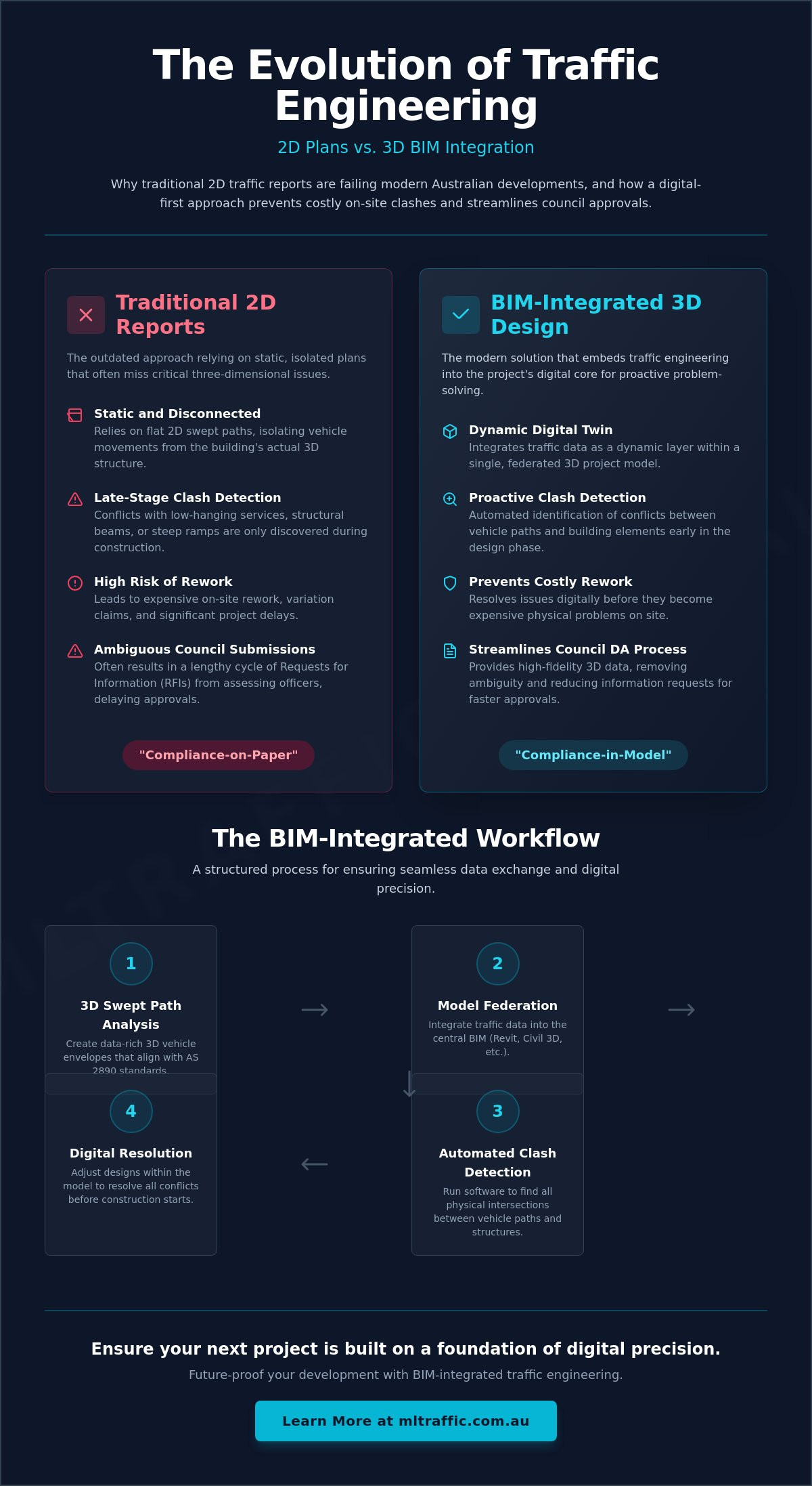
Static 2D diagrams cannot account for the vertical complexities of a modern multi-level development. Overhead services, structural beams, and fire sprinklers often conflict with the operating envelopes of heavy rigid vehicles (HRV) or waste collection trucks. A 2D plan might show a vehicle clearing a corner, but it won’t show the undercarriage scraping a steep driveway ramp. integrating traffic design with BIM models allows engineers to visualise the entire 3D volume of a vehicle path. This shifts the focus from ‘compliance-on-paper’ to ‘compliance-in-model’.
BIM Levels and Traffic Engineering Maturity
Understanding the distinction between BIM levels is essential for coordinating technical traffic engineering services. Level 2 BIM involves separate models from different disciplines that are federated for coordination. Level 3 represents full integration in a shared environment. For traffic engineers, this means moving beyond simple CAD lines to data-rich objects that carry information about vehicle types, turning radii, and clearance requirements. In 2026, the traffic engineer’s role has expanded to include active model management, ensuring transport planning data is a core component of the site’s digital twin.
Key technical considerations include:
- Interoperability: Seamlessly exporting 3D swept paths from specialised software like AutoTURN into Revit or Civil 3D.
- Data Integrity: Ensuring that vehicle specifications align with Australian Standards (AS 2890.1 and AS 2890.2).
- Clash Detection: Automated identification of physical intersections between vehicle paths and structural elements.
Key Components of BIM-Integrated Traffic Design
Transitioning from static compliance to a three-dimensional environment requires a precise digital translation of Australian Standards. Integrating traffic design with BIM models involves more than just placing 2D lines into a 3D file; it requires the creation of data-rich objects that reflect the physical and operational constraints of vehicle movement. This process ensures that compliance checks for AS 2890.1 and AS 2890.2 are performed against the actual structural geometry of the building. It removes the ambiguity of 2D plans.
A critical component is the development of a Vehicle Swept Path Analysis within the federated model. By using 3D envelopes, engineers can identify where a waste collection vehicle’s body or mirrors might strike a structural beam or fire service pipe. This level of detail is consistent with international best practices, such as those described in FHWA BIM Workflows, which advocate for integrated transport planning data to improve project outcomes. The model becomes a reliable testing ground.
3D Swept Path Envelopes and Vertical Clearance
Modelling the clearance zone for heavy rigid vehicles or delivery vans involves creating a ‘buffer’ around the vehicle’s dynamic path. We categorise these as ‘hard’ clashes, where the vehicle body physically strikes an object, or ‘soft’ clashes, where the vehicle enters a restricted safety zone. Precise 3D swept paths eliminate the need for costly structural rework by resolving clearance conflicts during the design phase. This approach also applies to driveway ramp grade assessments, where vertical curves are modelled to ensure low-clearance vehicles don’t scrape the pavement. The geometry is absolute.
AS 2890 Compliance in the Digital Model
Automating design checks within the BIM environment significantly reduces the risk of human error. By integrating AS 2890.1 design rules directly into Revit family objects, aisle widths and turn circles are validated in real-time as the architectural model evolves. This is particularly vital for sight distance assessments. Instead of relying on 2D triangles, we use 3D visibility cones to ensure drivers have an unobstructed view of pedestrians and other vehicles, accounting for columns, signage, and landscaping. It ensures safety is built into the model.
Dynamic parking demand modelling can also be integrated. This allows developers to visualise occupancy data and traffic flow patterns within the digital twin. This level of technical scrutiny ensures that the final car park design is not only compliant on paper but fully functional in the physical world. The result is a more efficient approval process.
BIM vs. Traditional Traffic Design: A Cost-Benefit Analysis
The financial risk of relying on traditional 2D traffic design is often buried in construction variation claims. Traditional workflows treat the Traffic Impact Assessment as a standalone document, detached from the structural and services models. Integrating traffic design with BIM models transforms this static data into a dynamic asset that identifies errors long before the first slab is poured. The accuracy of 3D visibility cones far exceeds 2D sight distance triangles, as the model accounts for the height and volume of every structural column, signpost, and plant box. It provides technical certainty.
This shift aligns with the Queensland Government BIM Guideline, which advocates for a digital-first approach to infrastructure. By using a federated model, developers ensure that transport planning is not an afterthought but a core design driver. The coordination is seamless.
Risk Mitigation and Error Reduction
Early clash detection is the most significant cost-saver in modern project delivery. Industry professionals report that identifying a vehicle clearance conflict with a major fire service pipe or structural beam during the design phase can save upwards of $50,000 in relocation costs and site delays. High-fidelity visual evidence from the model also reduces the volume of Council Requests for Information (RFI). Providing a clear, 3D demonstration of vehicle compliance builds immediate confidence with assessing officers. It simplifies the approval path and reduces project risk.
Time and Resource Efficiency
BIM-integrated workflows allow for rapid design iteration. Adjusting a car park layout in a 2D environment requires manual updates across multiple sections and elevations. In a 3D model, changes to aisle widths or bay angles propagate automatically, allowing for real-time compliance validation. This centralised source of truth ensures that Architects, MEP consultants, and Structural Engineers are all working from the same traffic data. This level of coordination is a hallmark of our traffic engineering services. The data is consistent.
The benefits extend beyond the construction phase. A BIM-ready traffic model serves as a long-term asset management tool. Facility managers can use the digital twin to plan future maintenance, coordinate loading dock schedules, or simulate the impact of future vehicle upgrades. The model provides value for the entire lifecycle of the building. It is a precise record of the site’s operational capacity.
Workflow: Integrating Traffic Design into Your Project BIM
Successful execution of integrating traffic design with BIM models begins with a robust Traffic Engineering BIM Execution Plan (BEP). This document must be established during the project’s inception to define the level of development (LOD), data exchange protocols, and coordination schedules. It ensures that the traffic engineer is a core participant in the federated model rather than a secondary reviewer. Following the ISO 19650 standards for information management ensures that transport data is structured, accessible, and ready for cross-disciplinary use. The process is methodical.
Technical coordination requires seamless data exchange between specialised traffic software and the primary architectural model. We export 3D swept paths from AutoTURN directly into Revit or Civil 3D environments. This allows the project team to visualise vehicle movements as physical volumes within the site’s digital twin. By treating vehicle paths as data-rich objects, we eliminate the inaccuracies associated with manual 2D drafting. The model remains the single source of truth throughout the project lifecycle.
Phase 1: Concept and Schematic Design
Initial modelling prioritises the definition of vehicle parameters based on AS 2890. We establish the operating envelopes for B99 cars, Small Rigid Vehicles (SRV), and Medium Rigid Vehicles (MRV) early in the design. These envelopes are integrated with the building’s Gross Floor Area (GFA) to perform preliminary car parking demand assessments. This early integration ensures that the building’s core structural grid can accommodate necessary vehicle movements without requiring late-stage redesigns. See our services page for more on conceptual traffic planning.
Phase 2: Detailed Design and Coordination
During detailed design, we use Navisworks to run automated clash detection between traffic envelopes and structural or MEP models. This identifies ‘hard’ clashes where a vehicle would strike a structural beam or ‘soft’ clashes where clearance zones are compromised by fire services or drainage pipes. We also conduct precise 3D modelling of driveway ramp grades and sight lines to ensure zero vehicle scraping and maximum safety. The final Traffic Impact Assessment is then produced using high-fidelity data extracted directly from the BIM. The analysis is precise.
The workflow concludes with the production of BIM-derived 2D plans for Council DA submission. While the analysis is performed in 3D, these derived plans provide the authoritative visual evidence required by assessing officers. This high-fidelity documentation significantly reduces the likelihood of Council Requests for Information (RFI) and streamlines the approval timeline. If you require technical certainty for your next development, contact our senior traffic engineers to discuss your project’s BIM requirements.
The Future of Traffic Engineering with ML Traffic Engineers
ML Traffic Engineers provide the technical framework for integrating traffic design with BIM models within existing project workflows. We organise complex transport data into structured, actionable layers that align with ISO 19650 standards. This approach ensures that your development is ready for the digital future of urban planning, where Councils increasingly require high-fidelity submissions. We deliver technical certainty. The data is precise.
Our national expertise allows us to provide compliant designs across all Australian jurisdictions. Whether your project is in Queensland, New South Wales, or Victoria, we ensure adherence to specific state-level BIM mandates and AS 2890 standards. Senior leadership is involved in every project. You have direct access to the experts performing the technical work. There are no gatekeepers.
Our Approach to Digital Compliance
We combine over 15 years of professional experience with the latest 3D swept path technology. Our traffic engineers focus on practical site solutions rather than just software outputs. We understand the physical limitations of construction and the bureaucratic requirements of local Councils. A key signature of our service is our personnel continuity promise; the senior engineer who initiates your project remains the technical BIM lead throughout the design lifecycle. This ensures total accountability.
Our digital compliance services include:
- Vehicle Swept Path Analysis: Precise 3D operating envelopes for all vehicle classes.
- Car Park Design: Automated validation of aisle widths and bay gradients.
- Driveway Ramp Grade Assessment: Modelling vertical curves to prevent vehicle scraping.
- Waste Management Plan Integration: Ensuring collection vehicles can safely access and exit the site.
Next Steps for Your Development
To ensure a seamless integration, include specific BIM requirements in your initial traffic engineering brief. Define the required Level of Development (LOD) and the federated model format early. This prevents data loss and ensures all consultants are aligned from the concept stage. We recommend booking a technical consultation to discuss your site’s specific 3D challenges, such as vertical clearances or complex intersection geometry. Early intervention is the most effective way to manage project risk.
Prepare your project for the digital future by establishing clear protocols for:
- Specifying the federated model format (e.g., Revit or Civil 3D).
- Defining vehicle types for 3D swept path analysis.
- Establishing data exchange intervals for clash detection.
Contact ML Traffic Engineers to integrate expert traffic design into your BIM model today and secure a faster path to Council approval.
Securing Design Certainty for Your Next Development
Adopting a 3D workflow is no longer optional for developers seeking to minimise construction risk and streamline Council approvals. Moving beyond static 2D reports to integrating traffic design with BIM models ensures that vehicle clearance zones are validated against structural reality. This proactive approach identifies potential clashes with services and columns before they become expensive site variations. It provides the technical evidence required to meet the latest NCC 2025 standards and state-specific digital mandates.
ML Traffic Engineers brings over 15 years of Australian traffic engineering experience to your project team. We ensure strict compliance with AS 2890.1 and AS 2890.2 while maintaining senior principal involvement in every project. This hands-on accountability guarantees that your transport data is accurate, federated, and ready for the construction phase. Our personnel continuity promise means the expert who starts your project is the one who delivers the final model.
Get a BIM-ready Traffic Assessment for your next project to ensure your design is fully coordinated and compliant. We look forward to helping you achieve a seamless approval process.
Frequently Asked Questions
What is the primary benefit of integrating traffic design with BIM?
The primary benefit is the automated identification of physical clashes between vehicle operating envelopes and structural or mechanical elements. By integrating traffic design with BIM models, developers can resolve clearance issues during the design phase rather than encountering expensive variations during construction. It provides a level of coordination that 2D plans cannot match.
Does a small residential development need BIM for traffic engineering?
While not always mandatory for smaller projects, BIM is highly recommended for any site with constrained basement parking or complex driveway gradients. It ensures that the transition grades comply with AS 2890.1 and that vehicles won’t scrape the pavement or strike overhead fire services. Technical certainty is valuable regardless of project scale.
Can 2D swept path analysis be converted into a 3D BIM model?
Yes, 2D swept paths can be transitioned into a 3D environment using specialised software that generates volumetric vehicle envelopes. These 3D objects are then exported into the federated model to perform clash detection against the architectural and structural geometry. This process transforms a static diagram into a dynamic coordination tool.
Which software is typically used for BIM-integrated traffic design in Australia?
Australian engineers predominantly use Autodesk Revit and Civil 3D for the primary modelling environment. AutoTURN 3D is the industry standard for generating vehicle envelopes, while Navisworks is used for cross-disciplinary clash detection. These tools allow for the seamless exchange of transport data within the project’s digital twin.
How does BIM integration affect the cost of a Traffic Impact Assessment?
Integrating traffic design with BIM models requires more technical hours during the design phase compared to traditional 2D drafting. However, this investment is offset by a significant reduction in Council RFI cycles and the prevention of costly site reworks. It shifts the project’s financial risk from the construction stage to the planning stage where changes are less expensive.
What Australian Standards govern car park design in a BIM environment?
The core standards remain AS 2890.1 for off-street car parking and AS 2890.2 for commercial vehicle facilities. In a BIM environment, these standards are digitalised into rule-based parameters within the model. This allows for real-time compliance checking of aisle widths, bay dimensions, and sight distances against the physical constraints of the building.
Will Council accept a 3D BIM model as part of a DA submission?
Most Australian Councils currently require 2D plans derived from the 3D model for formal DA submissions. However, providing high-fidelity 3D visualisations and clash reports as supporting evidence can significantly speed up the assessment process. State government projects and major infrastructure developments often have specific mandates for federated model deliveries.
How do I ensure my traffic engineer is BIM-capable?
Confirm that your traffic engineer follows ISO 19650 information management standards and has a proven track record of participating in federated models. They should be proficient in Revit or Civil 3D and able to provide a Traffic Engineering BIM Execution Plan (BEP). Direct access to the senior engineer performing the technical modelling is essential for accountability.

Disclaimer
The content on www.mltraffic.com.au, including all technical articles, guides, and resources, is provided for general informational and educational purposes only. It is not intended to constitute professional advice in traffic engineering, transportation planning, development approvals, or any other technical or legal field.While ML Traffic Engineers makes every reasonable effort to ensure the accuracy, completeness, and timeliness of the information published, we do not provide any warranties or representations (express or implied) regarding its reliability, suitability, or availability for any particular purpose. Any reliance you place on the content is strictly at your own risk.In no event shall ML Traffic Engineers, its directors, employees, authors, or affiliates be liable for any direct, indirect, incidental, special, consequential, or punitive damages (including, without limitation, loss of profits, data, or business opportunities) arising out of or in connection with the use of, or inability to use, any information provided on this website.The articles and guides on this site are not a substitute for engaging a qualified, registered professional traffic engineer (such as an NPER or RPEQ engineer) to assess your specific project requirements. For tailored advice, compliance assessments, or traffic engineering services, please contact a competent professional.This disclaimer may be updated from time to time without notice. By accessing or using this website, you agree to be bound by the most current version of this disclaimer.
