

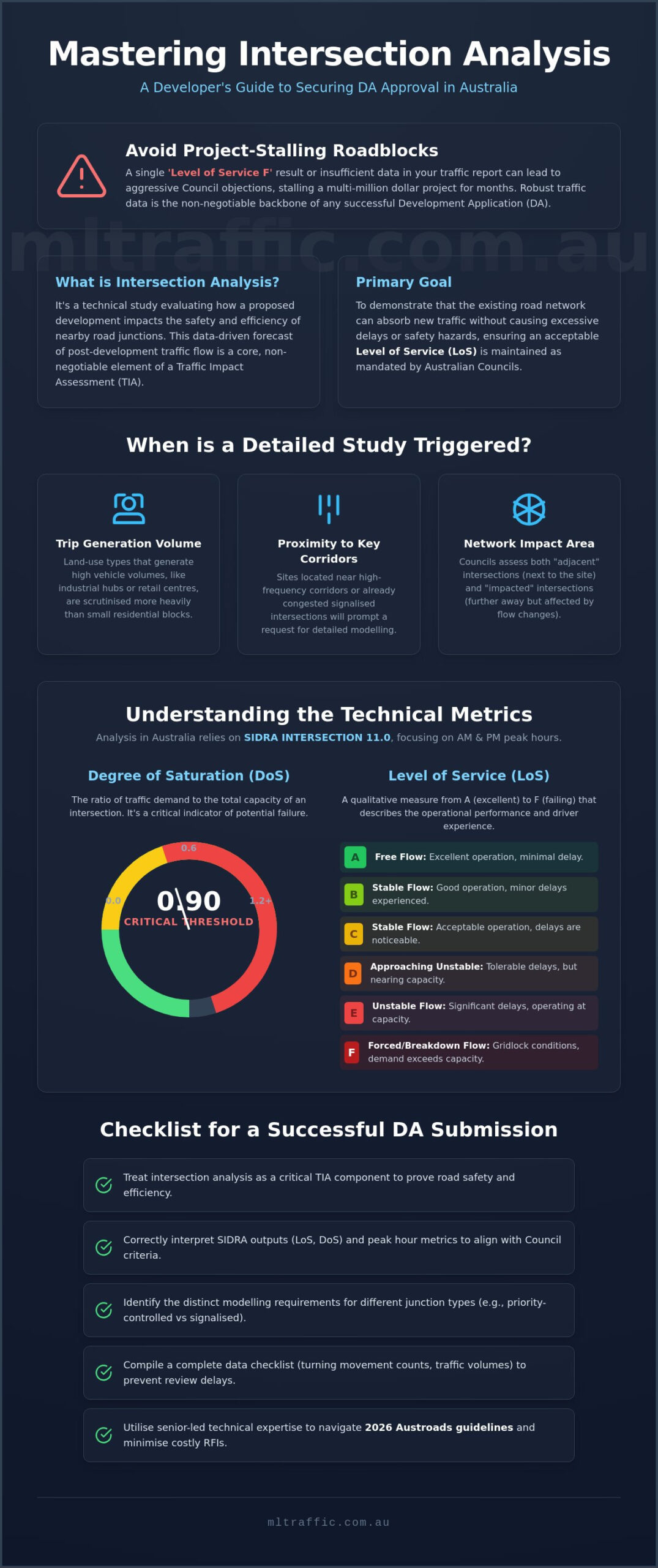
A single ‘Level of Service F’ result in your traffic report can stall a multi-million dollar project for months. When submitting an intersection analysis for development applications, developers often treat the modelling process as a mere box-ticking exercise, only to face aggressive Council objections regarding local congestion and insufficient data. You likely understand that robust traffic data is the backbone of any successful DA, yet the technical complexity of SIDRA 11 and updated ITE 12th Edition trip rates can lead to unexpected consultancy costs and frustrating requests for further information.
This guide will help you master the current technical requirements and Council expectations for intersection modelling, ensuring you secure your development approval with minimal conditions. We’ll examine the shift toward multimodal analysis in the Highway Capacity Manual 7th Edition, the nuances of the new SIDRA ASSIGN module, and how to present a compliant Traffic Impact Assessment (TIA) that satisfies even the most meticulous planning authority. By aligning your technical submission with 2026 regulatory standards, you can pre-emptively neutralise objections and maintain your project timeline.
Key Takeaways
- Understand how intersection analysis for development applications functions as a critical component of a Traffic Impact Assessment to ensure road safety and efficiency.
- Interpret key SIDRA INTERSECTION outputs and peak hour modelling metrics to align your project with specific Council performance criteria.
- Identify the distinct modelling requirements for various junction types, ranging from priority-controlled residential streets to complex signalised networks.
- Compile the necessary data checklist, including turning movement counts and site-specific traffic volumes, to prevent delays during the DA review process.
- Utilise senior-led technical expertise to navigate 2026 Austroads guidelines and minimise the risk of costly Requests for Information (RFIs) from planning authorities.
What is Intersection Analysis for Development Applications?
Intersection analysis for development applications is a technical study that evaluates how a proposed project influences the safety and efficiency of nearby road junctions. It functions as a core element of a Traffic Impact Assessment. Intersection analysis is a data-driven forecast of post-development traffic flow.
Australian Councils mandate these studies to ensure the local road network maintains an acceptable Level of Service (LoS). Planners use metrics like Intersection Capacity Utilization (ICU) to determine if a junction can handle additional vehicle movements without causing excessive delays or safety hazards. Without this data, a Development Application (DA) often faces immediate rejection or lengthy delays.
To better understand the dynamics of modern road design and efficiency, watch this helpful video:
When is an Intersection Study Triggered?
Most planning authorities apply specific thresholds to determine when a study is necessary. These triggers usually relate to the volume of vehicle trips generated by the land-use type; industrial hubs and retail centres are scrutinised more heavily than small residential blocks. Proximity to high-frequency corridors or already congested signalised intersections will also prompt a request for detailed modelling. Councils often distinguish between “adjacent” intersections, which are directly next to the site, and “impacted” intersections, which may be several hundred metres away but still experience significant flow changes.
Key Objectives for Developers
Your primary objective is to demonstrate that the existing network can absorb the new traffic load without failing. This involves justifying the location and design of your site access points to ensure they don’t create bottlenecks. If the modelling predicts a negative impact, the study provides the technical basis for identifying necessary infrastructure upgrades. This data-led approach helps you negotiate with Council and potentially reduce the scope of required works by proving exactly what is needed to maintain safety and efficiency.
- Network Absorption: Proving the current road capacity is sufficient for the development’s peak hour demands.
- Access Justification: Ensuring driveway locations meet sight distance and safety standards.
- Mitigation Strategy: Identifying specific upgrades, such as new turn lanes or signal phasing adjustments, to offset traffic growth.
Technical Metrics: Understanding SIDRA Outputs and Council Criteria
Traffic engineers in Australia rely on SIDRA INTERSECTION 11.0 to perform intersection analysis for development applications. This software models how vehicles interact at junctions under specific demand scenarios, primarily focusing on the morning (AM) and afternoon (PM) peak hours. These peaks represent the “worst-case” scenarios that a development must accommodate to satisfy regulatory requirements. By simulating these periods, engineers can predict how the local road network will perform once the project is operational.
One of the most critical metrics generated by this modelling is the Degree of Saturation (DoS). This value measures the ratio of traffic demand to the total capacity of the intersection. A Degree of Saturation over 0.90 typically triggers Council concerns. When a junction exceeds this threshold, it indicates that the infrastructure is nearing its limit, leading to unstable traffic flow and potential failure during peak periods.
Level of Service (LoS) Explained
The Level of Service (LoS) is a qualitative measure ranging from A (excellent) to F (failing). While the Caltrans Transportation Impact Study Guide provides an international perspective on these performance standards, Australian Councils follow Austroads guidelines to set local benchmarks. In dense urban centres, an LoS of D is often considered acceptable during peak periods. Conversely, regional authorities may demand a higher standard, such as LoS B or C, to preserve rural character and safety. It’s essential to recognise that while an intersection might have an overall LoS of C, specific movements, like a right-hand turn into a busy main road, could be failing at LoS F.
Delay and Queue Length
Councils also scrutinise average delay per vehicle and the 95th percentile queue length. The average delay indicates the time, in seconds, a driver waits to clear the intersection. The 95th percentile queue length is a statistical forecast of the maximum queue that will occur 95% of the time. This metric is vital for ensuring that vehicles queuing to enter your site do not spill back into adjacent junctions or block pedestrian crossings. Excessive queues compromise safety and can lead to a refusal of your application if mitigation strategies are not provided. Accurate modelling requires senior-level oversight to ensure the inputs reflect realistic site conditions. If you need assistance interpreting these technical outputs, you can speak with a senior principal to review your current modelling data.
Analysing Different Intersection Types and Scenarios
Intersection analysis for development applications must account for the specific geometry and control methods of each junction. Priority-controlled intersections, such as those using ‘Give Way’ or ‘Stop’ signs, are standard for residential subdivisions. While these are simpler than signals, they require precise gap-acceptance modelling to ensure side-street traffic can safely merge into the main flow. Roundabouts present different challenges, focusing on entry capacity and circulating flow dynamics. A well-designed roundabout manages high volumes efficiently, but it requires careful analysis of exit lane queuing to prevent internal blockages that stall the entire network.
Signalised intersections represent the most complex scenarios in a traffic study. Modelling these involves evaluating signal phasing, cycle times, and coordination with adjacent networks to maintain traffic ‘platooning’. If your development is near a major arterial road, Council will expect the intersection analysis for development applications to prove that your project won’t degrade existing green-wave coordination. We also integrate Swept Path Analysis at this stage. This ensures that heavy vehicles and emergency services can navigate the junction geometry without mounting kerbs or encroaching on opposing lanes.
New Site Access vs. Existing Public Intersections
Establishing a new site access point requires a different technical approach than assessing an existing public junction. We focus on conflict point analysis, comparing the safety of left-in/left-out access against all-movement junctions. Austroads and Australian Standards dictate strict sight distance requirements for these new points. If a proposed driveway lacks sufficient Safe Intersection Sight Distance (SISD), it will likely face a Council objection regardless of how well the traffic volume is handled. Proving safety through data is the only way to justify a new access point on a busy corridor.
Impact of Various Land-Use Categories
Traffic patterns vary significantly by land use, and your modelling must reflect these specific behaviours. Residential developments typically show high exit volumes during the AM peak and high entry volumes in the PM peak. Commercial and retail sites often experience high turnover throughout the day, including weekend peaks that may exceed weekday volumes. For industrial projects, the focus shifts almost entirely to heavy vehicle movements. These assessments require strict AS 2890.2 compliance to ensure the intersection can accommodate the turning circles of semi-trailers or B-doubles without compromising the Level of Service for other road users.
Preparing for the Assessment: Data Requirements for Developers
The accuracy of an intersection analysis for development applications relies entirely on the quality of the baseline data. Engineers cannot produce reliable SIDRA outputs without a precise understanding of existing road conditions and future growth projections. Developers must provide a comprehensive data package to avoid modelling errors that lead to Council Requests for Information (RFIs). High-quality data ensures the digital model reflects real-world physics and driver behaviour.
Existing traffic data is typically collected via two primary methods. Automatic Traffic Counters (ATCs), or tube counts, use pneumatic sensors to record total vehicle volumes and speeds over a seven-day period. While useful for general volume trends, they don’t capture directional movements at a junction. For detailed modelling, turning movement counts (TMCs) are essential. These involve manual or video observation to record every specific movement at an intersection during peak hours. We also incorporate background growth rates to account for regional traffic increases over a 10-year horizon, ensuring the development remains viable as the surrounding area grows.
Step 1: Traffic Count Collection
Identifying the relevant intersections within the study area is the first step in the data collection process. You must count every junction where your development’s traffic will significantly alter the Level of Service. Timing is critical; counts should never occur during school holidays, public holidays, or during major local events as these represent atypical road conditions. A professional study must distinguish between light vehicles, heavy vehicles, and cyclists. This classification is vital for SIDRA to calculate accurate gap acceptance and saturation flows, particularly for industrial projects with high heavy-vehicle percentages.
Step 2: Site Geometry and Phasing
Engineers must replicate the physical layout of the road in the digital model with high precision. This requires detailed architectural or civil plans of the proposed entry points, including lane widths, turn pocket lengths, and median locations. For signalised junctions, we liaise with state road authorities to obtain SCATS (Sydney Coordinated Adaptive Traffic System) data or equivalent signal timing information. This ensures the model accounts for actual phase times and coordination offsets. We also incorporate planned future road upgrades by state or local government to ensure your 10-year horizon modelling remains valid and compliant with long-term infrastructure strategies.
If you are preparing your DA submission, you can view our full range of intersection analysis and TIA services to ensure your data collection meets regulatory standards.
How ML Traffic Engineers Australia Streamline Your DA Approval
Securing a development approval requires more than just technical data; it requires a strategic presentation of that data to satisfy regulatory scrutiny. ML Traffic Engineers Australia leverages over 15 years of consultancy experience to navigate the specific requirements of local Councils across the country. Our approach to intersection analysis for development applications is defined by senior principal involvement. Unlike larger firms that may delegate complex modelling to junior staff, our senior experts perform the technical work themselves. This ensures that every SIDRA model and TIA report carries the authority and precision needed to withstand rigorous peer reviews.
Our commitment to personnel continuity means the senior engineer who initiates your project remains your primary point of contact throughout the entire DA process. This hands-on accountability eliminates communication gaps and ensures that the technical nuances of your site are fully understood during Council negotiations. We provide a holistic solution by integrating our analysis with professional Car Park Design. By aligning your internal site circulation with external intersection performance, we create a unified traffic strategy that reduces the likelihood of conflicting design requirements.
Proactive Objection Management
Our team is also qualified to provide expert witness and representation services for planning tribunals, such as VCAT or the NSW Land and Environment Court, should your project require formal legal advocacy. When preparing for these proceedings, developers can explore lawyer fees for legal representation, litigation and ongoing legal advice from firms like MZ-Law to ensure their case is adequately supported.
- Early Risk Identification: Detecting sight distance or capacity issues before lodgement.
- Technical Defence: Crafting detailed rebuttals to Council RFIs using verified SIDRA outputs.
- Tribunal Expertise: Providing authoritative testimony based on decades of engineering experience.
Get Started with a Professional Assessment
Every development project has unique variables that influence the scope of the required traffic study. To receive a tailored fee proposal, you can provide our team with your current site plans and the Council’s specific requirements. A typical SIDRA-based intersection report is completed within a structured timeframe, allowing you to maintain your project schedule without unnecessary delays. We focus on delivering compliant, results-oriented documentation that facilitates a smoother approval path. Contact our senior engineers today for a compliant intersection analysis to ensure your development meets all 2026 regulatory standards.
Secure Your Development Approval with Expert Modelling
Navigating the technical complexities of intersection analysis for development applications requires more than just software proficiency. As standards evolve in 2026, including the integration of SIDRA 11 and post-pandemic trip generation data, the margin for error in your DA submission has narrowed. Successful approvals depend on accurate Degree of Saturation modelling and clear Level of Service reporting that pre-emptively addresses Council concerns.
ML Traffic Engineers Australia provides over 15 years of traffic engineering excellence to ensure your project meets all Australian Standards. Our senior principals perform the technical work on every report, providing the meticulous oversight needed to minimise Requests for Information and avoid costly project delays. By combining expert intersection modelling with comprehensive site assessments, you can submit a Traffic Impact Assessment that planning authorities can trust.
This technical rigour is also found in specialised property assessments; for instance, firms like Modic explore infrared thermographic inspection to identify hidden leaks and structural issues with the same precision required for traffic modelling.
Take the first step toward a seamless approval process by engaging with our seasoned experts. We’re ready to provide the dependable, results-oriented analysis your project demands. Reach out to our team today to discuss your site requirements and secure a robust technical submission.
Get a Professional Intersection Analysis for Your DA
Frequently Asked Questions
What is the difference between a Traffic Impact Statement and a full Intersection Analysis?
A Traffic Impact Statement is a simplified qualitative report typically used for small scale developments with low trip generation. In contrast, a full intersection analysis for development applications involves quantitative SIDRA modelling to evaluate specific performance metrics like Degree of Saturation and queue lengths. Councils mandate the more detailed analysis when a project is expected to significantly influence the capacity or safety of the surrounding road network.
How much does a SIDRA intersection analysis typically cost for a DA?
The cost of a SIDRA analysis depends on the number of junctions being modelled and the complexity of the signal phasing or geometry involved. Fees are also influenced by the need for fresh traffic data collection, such as manual turning movement counts. A professional engineering firm provides a specific fee proposal after reviewing your site plans and the local Council’s requirements to ensure all technical variables are addressed.
Will I need to pay for road upgrades if the intersection fails the LoS test?
Developers are often required to fund or construct road upgrades if the modelling proves the development will degrade the intersection’s Level of Service (LoS) below acceptable limits. These requirements are usually included as conditions of consent in your DA approval. Mitigation measures can range from minor line marking changes to significant civil works like the installation of new traffic signals or additional turning lanes.
Can I use traffic data from a few years ago for my current development application?
Most Australian Councils and road authorities require traffic count data to be no more than 12 to 24 months old. Using outdated data often results in a formal Request for Information (RFI) because it does not account for recent background traffic growth or other new developments in the area. Accurate intersection analysis for development applications must be based on current peak hour volumes to be considered valid by planning authorities.
How long does it take for a traffic engineer to complete an intersection model?
A standard intersection model is usually completed within one to two weeks once all necessary traffic count data is available. This timeframe includes the digital construction of the intersection geometry, inputting traffic volumes, and running AM and PM peak hour simulations. Projects involving multiple coordinated signalised intersections or complex network modelling may require a longer period for technical calibration and senior review.
What happens if Council disagrees with the results of my traffic report?
If a Council traffic engineer disputes your findings, they will typically issue a request for further information or suggest a peer review of the model. Our senior principals manage this process by providing technical justifications for the modelling parameters and gap acceptance values used in the report. We rely on data-led evidence to resolve technical disagreements and ensure the DA remains on track for approval.
Do I need an intersection analysis for a small residential subdivision?
Small subdivisions don’t always trigger a full intersection study if the projected vehicle movements are below specific Council thresholds. However, an analysis may still be required if the site access is located on a major arterial road or near a junction with known safety issues. You should consult the local planning scheme to determine the exact trip generation triggers that apply to your specific land use and location.
What is SCATS data, and why do I need it for signalised intersection modelling?
SCATS data provides the actual signal phasing and timing sequences used by road authorities to manage traffic flow. Engineers use this information in SIDRA modelling to ensure the digital simulation matches the real-world operation of the traffic lights. Without accurate SCATS data, the model cannot reliably calculate vehicle delays or 95th percentile queue lengths, which are critical metrics for Council approval.

Disclaimer
The content on www.mltraffic.com.au, including all technical articles, guides, and resources, is provided for general informational and educational purposes only. It is not intended to constitute professional advice in traffic engineering, transportation planning, development approvals, or any other technical or legal field. While ML Traffic Engineers makes every reasonable effort to ensure the accuracy, completeness, and timeliness of the information published, we do not provide any warranties or representations (express or implied) regarding its reliability, suitability, or availability for any particular purpose. Any reliance you place on the content is strictly at your own risk. In no event shall ML Traffic Engineers, its directors, employees, authors, or affiliates be liable for any direct, indirect, incidental, special, consequential, or punitive damages (including, without limitation, loss of profits, data, or business opportunities) arising out of or in connection with the use of, or inability to use, any information provided on this website. The articles and guides on this site are not a substitute for engaging a qualified, registered professional traffic engineer (such as an NPER or RPEQ engineer) to assess your specific project requirements. For tailored advice, compliance assessments, or traffic engineering services, please contact a competent professional. This disclaimer may be updated from time to time without notice. By accessing or using this website, you agree to be bound by the most current version of this disclaimer.
