
We are traffic engineers servicing Melbourne metropolitan area, Mornington Peninsula and surrounding regions including Geelong.
Are the 2026 changes from the Metro Tunnel creating unforeseen challenges for your business or development? You are not alone. The new timetables have shifted commuter behaviour, creating unexpected road congestion around station precincts and leaving many developers uncertain about revised parking requirements. Understanding the complete metro tunnel melbourne travel impact is no longer optional-it’s essential for strategic planning. This project represents a fundamental shift in the city’s transport network, and its effects on traffic flow, accessibility, and land use are significant and complex.
This article provides a direct, professional assessment of this new reality. We will analyse the definitive changes to travel times across the network, identify how CBD road traffic has been re-routed and reduced, and deliver actionable insights for businesses and developers. Gain the clarity needed to navigate the new transport landscape, ensure your projects comply with updated planning expectations, and leverage these changes for commercial advantage.
Key Takeaways
- Understand the new travel time reality, identifying which rail lines now offer faster CBD access and which have been rerouted through the City Loop.
- Assess the real-world metro tunnel melbourne travel impact on major freeways and CBD traffic, and what it means for your road-based commute or project.
- Learn why your pre-2026 Traffic Impact Assessment (TIA) is likely obsolete and how council expectations for parking have fundamentally changed.
- Discover the new data-driven approach required to get your development’s traffic management plans approved in the post-tunnel era.
Table of Contents
- The ‘Big Switch’ Explained: Melbourne’s New Rail Equilibrium
- The Travel Time Ripple Effect: Winners and Losers in 2026
- Beyond the Tracks: How Rail Expansion Changes Road Congestion
- Adapting Your Development to the Metro Tunnel Era
- Why Professional Traffic Planning is Essential Post-Tunnel
The ‘Big Switch’ Explained: Melbourne’s New Rail Equilibrium
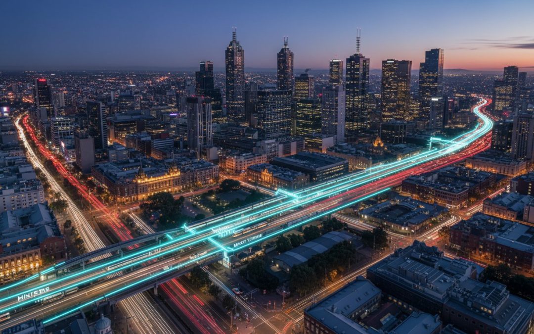
The “Big Switch” represents the most profound re-engineering of Melbourne’s rail network since the City Loop opened in the 1980s. At its core, this A$14 billion project involves the permanent decoupling of the Sunbury, Cranbourne, and Pakenham lines from the congested City Loop, redirecting them through a new dedicated cross-city tunnel. This strategic separation is designed to untangle the network, creating a new equilibrium that boosts capacity and reliability. The overall metro tunnel melbourne travel impact is a direct result of this fundamental operational shift, affecting the daily commute for over 500,000 Melburnians.
To visualise how this new infrastructure alleviates the city’s primary rail bottleneck, the following overview is instructive.
The immediate outcome of this reconfiguration is a significant increase in service frequency. The network now benefits from over 1,000 new weekly services, a direct injection of capacity where it is most needed. This expansion isn’t merely about adding trains; it’s about creating a more resilient, metro-style system. The ambitious scope, detailed in this comprehensive Metro Tunnel project overview, establishes a new north-west to south-east rail corridor that operates independently, thereby reducing the cascading delays that previously plagued the interconnected lines.
The New Station Precincts: Arden to Anzac
The project’s success is also defined by its five new underground stations, which create vital new connection points and urban renewal opportunities.
- Arden: Transforms a former industrial zone into a high-connectivity hub, catalysing development in North Melbourne.
- Parkville: Directly addresses the “last mile” problem for the city’s premier health and education precinct, providing fast, direct rail access for staff, students, and patients.
- Anzac: Strategically positioned on St Kilda Road, this station is designed to shift commuter volume from one of the world’s busiest tram corridors to the new underground line, fundamentally altering travel patterns.
High-Capacity Signalling and Travel Reliability
Underpinning the entire operational improvement is the implementation of High-Capacity Signalling (HCS). This technology moves beyond traditional fixed-block signals, allowing trains to run closer together safely and dynamically. The primary function of HCS is to reduce “train bunching” and minimise delays, leading to more predictable journey times. While initial data from the 2026 rollout shows progress towards the promised 2-minute peak frequencies, the initial months have not been without technical glitches. Addressing these early-stage integration challenges remains a key focus for ensuring long-term system reliability.
The Travel Time Ripple Effect: Winners and Losers in 2026
The full operational launch of the Metro Tunnel in 2026 has fundamentally reconfigured Melbourne’s public transport network. The primary metro tunnel melbourne travel impact is not just about speed, but a redistribution of accessibility that has created clear winners and necessitated some operational trade-offs. The most significant beneficiaries are commuters on the Sunbury line, who now experience a direct, high-capacity service into the heart of the CBD, saving up to 15 minutes on a one-way trip. This enhancement also positively affects regional passengers from Geelong, Ballarat, and Bendigo, who benefit from faster, more reliable transfers at Sunshine station for the new city-bound services.
Conversely, this network redesign required adjustments. To facilitate the new high-frequency cross-city line, Frankston line services were redirected to run exclusively through the City Loop. While this provides consistent service, it altered long-standing travel patterns for some commuters, representing a calculated trade-off for greater network-wide efficiency.
CBD Accessibility: The State Library and Town Hall Hubs
The new State Library and Town Hall stations provide direct, turn-up-and-go access to the northern and southern spines of the CBD, bypassing the often-congested City Loop. This has a direct effect on pedestrian flow and the “last mile” of a commute. Analysis shows a significant reduction in passenger interchange pressure at Melbourne Central and Flinders Street stations, as confirmed by data on the official Metro Tunnel project page. This dispersal of passengers means less time is spent navigating crowded platforms and more time at the destination.
- Direct Precinct Access: Commuters can now directly access the legal and medical districts near State Library station and the retail core around Town Hall station without secondary tram transfers.
- Decongestion: Spreading passenger loads across five underground CBD stations has measurably eased pedestrian bottlenecks.
The average cross-city commute from the west to the south-east has been reduced by up to 30 minutes in 2026.
The Suburban Connectivity Boost
The tunnel effectively creates a single, uninterrupted rail line from Sunbury in the west to Cranbourne and Pakenham in the south-east, “shrinking” the perceived distance between these major growth corridors. A secondary metro tunnel melbourne travel impact is observed in property values, with analysis showing a marked uplift in areas surrounding the new and upgraded high-frequency stations.
A notable case study is the shift in travel behaviour for Monash University’s Caulfield campus community. Students and staff travelling from western suburbs can now reach the campus via a single, direct train journey, eliminating the previous multi-change commute and reducing reliance on private vehicles.

Beyond the Tracks: How Rail Expansion Changes Road Congestion
The primary function of a major rail project is to move people efficiently via public transport. However, a critical secondary effect, and a key measure of success, is its influence on existing road networks. The concept of “mode shift”-persuading commuters to abandon their cars-is central to the project’s value proposition. The key question for traffic engineers is whether this shift is measurably reducing vehicle volumes on major arteries like the Monash Freeway and West Gate Bridge.
The most significant changes are observed in and around the CBD. The introduction of five new underground stations fundamentally alters how people access central Melbourne. While the full picture is still emerging, initial traffic assessments point towards a reduction in private vehicle trips into the Hoddle Grid, particularly during peak hours. The transformation of St Kilda Road, with the new Anzac Station, is a prime example. This project, detailed in the Official Metro Tunnel Project Overview, reallocates road space and changes traffic light sequencing, prioritising tram and pedestrian movements over historic vehicle dominance. Understanding the full metro tunnel melbourne travel impact requires analysing these granular, street-level changes.
Decreased Car Dependency in Key Precincts
Specific precincts with new stations are experiencing profound changes. In Parkville, home to major hospitals and The University of Melbourne, the project aims to significantly reduce demand for all-day staff and visitor parking. Further north, the Arden-Macaulay urban renewal zone is being planned with a “pedestrian-first” mindset, leveraging its new station to minimise car dependency from its inception. For commercial operators, this translates to more reliable delivery and logistics timing as arterial road congestion eases.
The Impact on Local Road Networks
Improving rail infrastructure does not eliminate the need for road planning; it simply changes the focus. The success of the tunnel creates new pressure points that require expert traffic engineering solutions. Key challenges include:
- Concentrated Drop-Off Zones: Increased passenger volumes at suburban stations on the Cranbourne, Pakenham, and Sunbury lines lead to more intense morning and evening peaks in “kiss-and-ride” zones, requiring redesigns for safety and flow.
- New Pedestrian Desire Lines: Station entrances create high-volume pedestrian routes that cross existing roads. This demands updated signal phasing, new crossing infrastructure, and comprehensive safety assessments.
- Updated Traffic Guidance Schemes (TGS): Local councils and road authorities must develop and implement new TGS to manage vehicle flow around these newly bustling transport hubs.
Ultimately, the metro tunnel melbourne travel impact demonstrates that major rail projects demand smarter, more responsive local road management, not less of it. The challenge shifts from managing through-traffic to managing destination-based congestion.
Adapting Your Development to the Metro Tunnel Era
The opening of the Metro Tunnel fundamentally resets the baseline for traffic and transport planning in Melbourne. A Traffic Impact Assessment (TIA) conducted in 2024, or even early 2025, is now insufficient for a Development Application (DA) in 2026. The pre-tunnel traffic data and public transport assumptions it was based on are obsolete. This new infrastructure creates an imperative for developers to reassess their site plans, particularly regarding car parking provisions and site access.
Councils are rapidly adjusting their expectations. For developments near the new stations-Parkville, Arden, State Library, Town Hall, and Anzac-there is a clear push for significant parking reductions. This is no longer a “nice-to-have” sustainability goal; it is a core planning expectation. Developers can now leverage the positive metro tunnel melbourne travel impact to justify lower car parking provisions, reducing construction costs and maximising yield. However, this justification must be supported by a robust, expert-led traffic engineering report.
Navigating New Parking Demand Assessments
In these high-density precincts, strict compliance with Australian Standard AS 2890.1 is being viewed through a new lens. While the standard remains critical, its application must now account for reduced private car dependency. We are seeing a decisive shift towards innovative solutions like “unbundled” parking, where spaces are sold or leased separately from apartments, and dedicated car-share bays. To navigate this new landscape and ensure your design is both compliant and commercially viable, developers should consult our services to optimize site access and parking strategy.
Strategic Planning for Arden and Parkville Developments
The Arden Urban Renewal Precinct is a prime example of this new paradigm. Planning authorities have specific requirements for integrated transport and active travel, placing immense scrutiny on how a development manages vehicle movements. For any project in these high-activity rail zones, a detailed Swept Path Analysis becomes non-negotiable to ensure safe and efficient access for service and delivery vehicles on constrained sites. An experienced Traffic Engineer is essential for managing construction traffic and negotiating directly with the Department of Transport and Planning to secure approvals.
Why Professional Traffic Planning is Essential Post-Tunnel
The completion of the Metro Tunnel in 2025 will fundamentally redraw Melbourne’s transport map, creating the most significant network shift in a generation. Traffic patterns that have been predictable for decades will be altered, rendering outdated traffic models and assumptions obsolete. For developers, architects, and project managers, relying on pre-tunnel data for a Traffic Impact Assessment (TIA) is a direct path to council objections, costly RFIs (Requests for Further Information), and potential planning rejections at VCAT. A “business as usual” approach is no longer a viable strategy.
To navigate this complexity, your project requires a traffic engineering partner that operates with post-2025 data and insights. At ML Traffic Engineers Pty Ltd, we provide expert analysis of the comprehensive metro tunnel melbourne travel impact on local and arterial road networks. Our assessments are built on forward-looking models that account for new commuter behaviours, altered public transport catchments, and rerouted traffic flows. This proactive approach is critical to ensuring your project isn’t stalled by outdated traffic assumptions that no longer reflect the on-the-ground reality of the city’s network.
Expert Insights for a Changing City
Our principal-led approach means senior engineers directly handle the detailed analysis of the complex intersection between new rail services, existing tram routes, and local road traffic for your Development Application (DA). With over 15 years of dedicated experience navigating Victorian planning schemes and council requirements, we possess the specialist knowledge required for the most complex sites. You can learn more about our team and our direct, hands-on approach to every project.
Secure Your Planning Approval
A meticulously prepared and robust TIA is your project’s best defense against planning objections. We stand by our unique “no-gatekeepers” promise: the senior engineer who provides your quote is the expert who completes the technical work and sees your project through to approval. This model ensures unparalleled accountability and direct access to expertise when you need it most, streamlining the entire process. Ready to move your project forward with confidence? Contact our Melbourne office today.
Securing Your Project’s Success in the Post-Tunnel Era
The completion of the Metro Tunnel marks a fundamental shift in Melbourne’s transport network. This project will recalibrate travel times, alter road congestion patterns, and redefine site accessibility across the city. Understanding the full metro tunnel melbourne travel impact is therefore not just an advantage for developers; it is an operational necessity for securing planning approval and ensuring long-term project viability.
Navigating this new reality requires specialised expertise. At ML Traffic Engineers, we provide the authoritative analysis your project needs. With assessments completed for over 10,000 sites across Australia, our senior engineers, Michael Lee and Benny Chen, deliver expert guidance on critical compliance issues, including AS 2890.1 parking and access standards. We ensure your development is not just planned, but proven to work within Melbourne’s future traffic environment.
Ensure your project is positioned for a seamless council approval process. Get a professional Traffic Impact Assessment for your Melbourne project and build with confidence.
Frequently Asked Questions
How much time does the Metro Tunnel actually save on a typical commute?
The primary time saving comes from a more direct path through the CBD and the removal of bottlenecks. For example, a Sunbury line passenger travelling to the Parkville university and hospital precinct could save up to 25 minutes on a one-way trip. Similarly, a Cranbourne/Pakenham line passenger heading to St Kilda Road can expect to save around 20 minutes. These efficiencies are achieved by bypassing the City Loop and providing direct access to new CBD locations.
Has the Metro Tunnel reduced traffic congestion on the Monash Freeway?
The Metro Tunnel’s primary objective is to increase the capacity and reliability of the rail network, not to directly reduce road congestion. While a significant mode shift from private vehicles to public transport is an intended secondary benefit, its direct impact on specific corridors like the Monash Freeway is difficult to quantify. Any reduction in traffic would be an indirect, long-term outcome rather than an immediate, measurable effect of the tunnel’s opening. Traffic modelling anticipates a city-wide benefit, not a targeted freeway solution.
Does proximity to a new Metro Tunnel station reduce my development’s parking requirements?
Yes, proximity to a high-capacity transport hub like a Metro Tunnel station provides a strong justification for a reduction in statutory car parking rates for a new development. A comprehensive Car Parking Demand Assessment must be prepared to demonstrate to the responsible authority how the enhanced public transport access reduces reliance on private vehicles for future residents or employees. This assessment is critical for planning permit applications and analyses the overall metro tunnel melbourne travel impact on your site.
What is the “Big Switch” and how does it affect the Sunbury and Pakenham lines?
The “Big Switch” refers to the final, critical commissioning stage where Sunbury and Pakenham/Cranbourne line trains are permanently rerouted to run through the new Metro Tunnel. This will create a single, end-to-end line from Sunbury in the west to Cranbourne/Pakenham in the southeast. This separation from the City Loop is fundamental to the project, untangling the network and allowing for more trains to run more frequently and reliably across the entire system.
How has the Parkville station impacted traffic around the Royal Melbourne Hospital?
The operational Parkville station is designed to significantly reduce car dependency in the dense medical and research precinct. By providing direct rail access for thousands of staff, students, and patients daily, the station alleviates pressure on local roads and parking facilities. While construction caused temporary disruptions, the long-term traffic impact is a net positive, improving accessibility and encouraging a sustainable mode shift away from private vehicle trips to the area.
Is a new Traffic Impact Assessment required for projects near the Metro Tunnel?
For any new development application or a significant amendment to an existing permit, a new or updated Traffic Impact Assessment (TIA) is almost certainly required. The introduction of new stations and altered transport patterns fundamentally changes the local traffic environment. A professional TIA is necessary to accurately assess vehicle access, pedestrian movements, loading arrangements, and parking demand in the context of the new infrastructure, ensuring compliance with council planning requirements.
How does the Metro Tunnel affect V/Line passengers from regional Victoria?
The Metro Tunnel project reconfigures how regional services operate through Melbourne. V/Line trains from the Geelong, Ballarat, and Bendigo lines will run directly to and from Southern Cross Station, no longer travelling through the City Loop. This provides a more dedicated and reliable path for regional services. Passengers wishing to access City Loop stations will need to interchange to a metropolitan service at key hubs like Southern Cross or Footscray.
What are the main travel disruptions still expected in 2026?
As the project nears completion in 2025 and enters its operational phase, disruptions will shift from construction-based to network integration. Commuters should anticipate significant timetable changes across most metropolitan and some regional lines. There will also be planned service alterations, particularly on weekends and overnight, for final testing, driver training, and the commissioning of the “Big Switch.” These are essential to ensure the system operates safely and efficiently once fully open.
Which suburbs of Melbourne do you prepare traffic impact reports?
Abbotsford, Aberfeldie, Aintree, Airport West, Albanvale, Albert Park, Albion, Alphington, Altona, Altona Meadows, Altona North, Ardeer, Armadale, Arthurs Seat, Ascot Vale, Ashburton, Ashwood, Aspendale, Aspendale Gardens, Attwood, Avondale Heights, Balaclava, Balwyn, Balwyn North, Bangholme, Bayswater, Bayswater North, Beaconsfield, Beaumaris, Bellfield, Bentleigh, Bentleigh East, Berwick, Bittern, Blackburn, Blackburn North, Blackburn South, Bonbeach, Boronia, Box Hill, Box Hill North, Box Hill South, Braeside, Braybrook, Brentford Square, Brighton, Brighton East, Broadmeadows, Brooklyn, Brunswick, Brunswick East, Brunswick West, Bulla, Bulleen, Bundoora, Burnley, Burnside, Burwood, Burwood East, Cairnlea, Camberwell, Campbellfield, Canterbury, Carlton, Carlton North, Carnegie, Caroline Springs, Carrum, Carrum Downs, Caulfield, Caulfield East, Caulfield North, Caulfield South, Chadstone, Chelsea, Chelsea Heights, Cheltenham, Chirnside Park, Clarinda, Clayton, Clayton South, Clematis, Clifton Hill, Coburg, Coburg North, Cocoroc, Coldstream, Collingwood, Coolaroo, Craigieburn, Cranbourne, Cranbourne East, Cranbourne North, Cranbourne South, Cranbourne West, Cremorne, Croydon, Croydon Hills, Croydon North, Croydon South, Dandenong, Dandenong North, Dandenong South, Deer Park, Delahey, Derrimut, Diamond Creek, Diggers Rest, Dingley Village, Docklands, Doncaster, Doncaster East, Donnybrook, Donvale, Doreen, Doveton, Eaglemont, East Melbourne, Edithvale, Elsternwick, Eltham, Eltham North, Elwood, Emerald, Endeavour Hills, Epping, Essendon, Essendon Fields, Essendon North, Essendon West, Fairfield, Fawkner, Ferntree Gully, Ferny Creek, Fitzroy, Fitzroy North, Flemington, Footscray, Forest Hill, Frankston, Frankston North, Frankston South, Gardenvale, Gladstone Park, Glen Huntly, Glen Iris, Glen Waverley, Glenroy, Greensborough, Greenvale, Guys Hill, Hadfield, Hampton, Hampton East, Hampton Park, Harkaway, Hawthorn, Hawthorn East, Heathmont, Heidelberg, Heidelberg Heights, Heidelberg West, Highett, Hillside, Hoppers Crossing, Hughesdale, Huntingdale, Hurstbridge, Ivanhoe, Ivanhoe East, Jacana, Kalkallo, Kealba, Keilor, Keilor Downs, Keilor East, Keilor Lodge, Keilor North, Keilor Park, Kensington, Kew, Kew East, Keysborough, Kings Park, Kingsbury, Kingsville, Knoxfield, Lalor, Langwarrin, Laverton, Laverton North, Lilydale, Lower Plenty, Lynbrook, Lyndhurst, Lysterfield, Macleod, Maidstone, Malvern, Malvern East, Maribyrnong, McCrae, Meadow Heights, Melbourne, Mentone, Mernda, Mickleham, Middle Park, Mill Park, Mitcham, Mont Albert, Mont Albert North, Montmorency, Moonee Ponds, Moorabbin, Mooroolbark, Mordialloc, Mornington, Mount Waverley, Mulgrave, Murrumbeena, Narre Warren, Narre Warren North, Narre Warren South, Newport, Niddrie, Noble Park, Noble Park North, North Melbourne, Northcote, Notting Hill, Nunawading, Oak Park, Oaklands Junction, Oakleigh, Oakleigh East, Oakleigh South, Officer, Ormond, Pakenham, Parkdale, Park Orchards, Pascoe Vale, Pascoe Vale South, Patterson Lakes, Plenty, Point Cook, Port Melbourne, Portsea, Prahran, Preston, Princes Hill, Reservoir, Richmond, Ringwood, Ringwood East, Ringwood North, Ripponlea, Rosanna, Rosebud, Rowville, Roxburgh Park, Rye, Sandhurst, Sandringham, Scoresby, Seabrook, Seaholme, Seddon, Seaford, South Kingsville, South Melbourne, South Morang, South Wharf, South Yarra, Southbank, Spotswood, St Albans, St Helena, St Kilda, St Kilda East, St Kilda West, Strathmore, Sunshine, Sunshine North, Sunshine West, Surrey Hills, Sydenham, Tarneit, Taylors Hill, Taylors Lakes, Templestowe, Templestowe Lower, Thomastown, Thornbury, Toorak, Tottenham, Travancore, Truganina, Tullamarine, Vermont, Vermont South, Viewbank, Wantirna, Wantirna South, Watsonia, Watsonia North, Werribee, Werribee South, West Footscray, West Melbourne, Westgarth, Wheelers Hill, Wildwood, Williamstown, Williamstown North, Windsor, Wonga Park, Wyndham Vale, Yallambie, Yarraville.
