
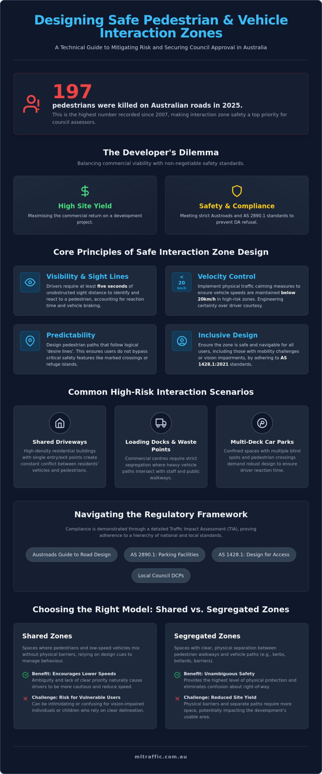
197 pedestrians were killed on Australian roads in 2025, the highest number recorded since 2007. This data has prompted road authorities to prioritise safety over vehicle throughput, making pedestrian and vehicle interaction zone design a primary focus for council assessors. You likely understand the difficulty of balancing site yield with the safety buffers required by Austroads and AS 2890.1. Conflicting requirements often lead to requests for information or outright DA refusal, stalling your project and increasing liability risk.
This guide provides the technical clarity needed to design safe, compliant interaction zones that meet regulatory standards and secure council approval. You’ll learn how to navigate complex requirements while maintaining efficient traffic flow. We examine the application of swept path analysis, sight distance requirements, and the specific design markers that minimise accident risk within your development.
Key Takeaways
- Identify the technical requirements for five-second visibility sight lines and physical velocity control to maintain vehicle speeds below 20km/h.
- Evaluate the operational benefits of shared spaces versus segregated zones to determine the most effective model for your site’s movement and place needs.
- Master pedestrian and vehicle interaction zone design to meet stringent council safety criteria and avoid project delays caused by RFIs.
- Utilise professional Traffic Impact Assessments and swept path analysis to demonstrate compliance with AS 2890.1 and Austroads standards.
- Navigate the complexities of balancing high site yield with necessary safety buffers to ensure both commercial viability and user safety.
What is Pedestrian and Vehicle Interaction Zone Design?
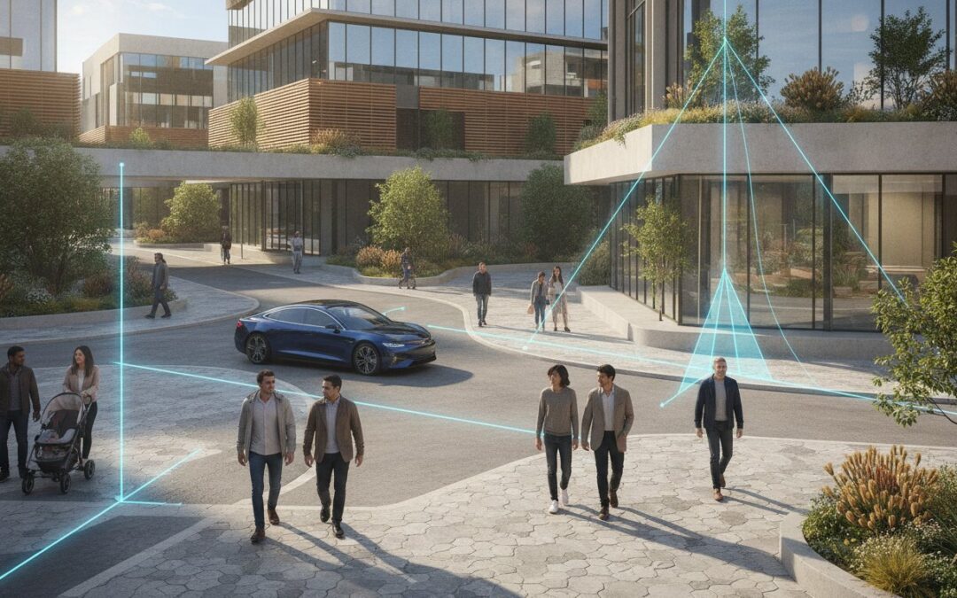
Pedestrian and vehicle interaction zone design is the technical engineering of designated areas where foot traffic and motorised vehicles occupy the same or adjacent spaces. These zones represent a high-risk nexus where transport planning meets urban safety. The primary goal is to minimise the probability of conflict while maintaining the efficient movement of all road users. In the context of Australian property development, these designs are critical for both Workplace Health and Safety (WHS) compliance and the successful progression of a Development Application (DA).
A well-designed pedestrian zone within a private development must account for human error and vehicle physics. Council planners scrutinise these areas because they are the most likely locations for onsite accidents. If a design fails to provide adequate sight lines or velocity control, it will likely trigger a Request for Information (RFI) or an outright rejection. Professional design ensures that safety is engineered into the site layout rather than added as an afterthought.
To better understand the physical implementation of these safety measures, watch this brief demonstration of barrier integration:
The Legal and Regulatory Context in Australia
Technical compliance in Australia relies on a hierarchy of standards and guidelines. Adherence to AS 2890.1 for off-street car parking is the baseline requirement for most developments. This standard dictates specific internal walkways and sight distance parameters. Additionally, the Austroads Guide to Road Design provides the national benchmark for managing traffic flow and pedestrian safety. Local councils often apply these national guidelines with additional layers of scrutiny, interpreting safety requirements based on local precinct plans. Proving compliance requires detailed documentation, often in the form of a Traffic Impact Assessment (TIA).
Common Interaction Scenarios in Modern Developments
Modern urban developments present several high-risk scenarios that require specialised engineering oversight. These include:
- Shared driveways: High-density residential flat buildings often use a single point of entry for residents and service vehicles, creating constant conflict points.
- Loading docks and waste points: Commercial centres require heavy vehicle access. These areas often intersect with pedestrian paths used by staff, necessitating strict segregation.
- Multi-deck car parks: These environments contain multiple pedestrian crossings. Pedestrian and vehicle interaction zone design must ensure drivers have sufficient reaction time in confined spaces.
Successful projects integrate these zones early in the site planning phase. This proactive approach ensures that safety buffers don’t compromise site yield later in the design process. Meticulous planning at this stage reduces the risk of onsite accidents and ensures long-term operational efficiency.
Core Principles of Safe Interaction Zone Design
Effective pedestrian and vehicle interaction zone design relies on engineering certainty rather than driver courtesy. A safe environment is achieved when the physical layout dictates user behaviour. Designers must prioritise visibility, velocity control, and predictability to satisfy both safety requirements and council expectations. Failing to address these fundamentals often results in site layouts that are functionally flawed and difficult to rectify once construction begins.
Sight Distance and Visibility Standards
Minimum sight distances are calculated based on expected approach speeds. In a high-density development, even a small obstruction can create a dangerous blind spot. Landscaping, signage, and structural columns must be positioned outside of critical sight triangles. Maintaining these lines of sight is a 24-hour requirement. High-quality lighting is essential to ensure pedestrians remain visible during low-light conditions and night-time operation. Professional sight distance assessments are often required to prove these standards are met during the DA process.
Physical Speed Management Measures
Passive speed control is more effective than signage alone. Physical measures like speed humps, raised thresholds, and narrow lane widths force drivers to reduce speeds to below 20km/h. Texture changes, such as the use of cobbles or coloured concrete, provide tactile and visual cues that signal a high-priority pedestrian area. Physical speed management is a cornerstone of pedestrian and vehicle interaction zone design, as it mitigates the severity of potential impacts.
Determining the exact placement of these features requires technical precision. Using Swept Path Analysis allows engineers to model vehicle movements accurately. This ensures that speed-calming measures, such as chicanes or tightened kerb radii, don’t impede the path of waste collection trucks or emergency vehicles. Balancing these technical constraints is essential for creating a functional and compliant development.
Shared Spaces vs. Segregated Zones: Choosing the Right Model
Selecting the appropriate framework for pedestrian and vehicle interaction zone design is a technical decision based on risk profile and operational requirements. Developers generally choose between shared space models, segregated infrastructure, or a hybrid of both. The choice depends on traffic volume and site constraints. While shared environments encourage user negotiation, segregated zones rely on physical exclusion to prevent contact. Most Australian commercial developments utilise a hybrid model to balance accessibility with rigorous safety standards.
When to Implement a Shared Space Model
Shared spaces are most effective in low-speed environments where vehicle velocity is strictly maintained under 10km/h. By removing traditional kerbs, line markings, and signage, these designs force drivers and pedestrians to engage in active negotiation. This model significantly reduces “visual clutter” and can improve the aesthetic value of a precinct. Increased driver alertness is a primary benefit, as the lack of formal structure requires more frequent scanning of the environment. However, it introduces risks for vision-impaired users. Without clear tactile ground surface indicators (TGSIs), these users may struggle to identify vehicle paths. Shared models are best suited for high-priority pedestrian areas like retail forecourts where vehicle movements are infrequent and predictable.
The Necessity of Segregated Infrastructure
Physical segregation is mandatory for high-volume vehicle areas or zones where heavy vehicles operate. Loading docks, waste collection points, and main thoroughfares require “safe havens” for pedestrians. Bollards, fencing, and grade separation provide a definitive barrier that eliminates the possibility of accidental encroachment. These zones must adhere to specific dimensions and clearance requirements to remain functional. Ensuring compliance with AS 2890.1 car park design is essential when planning segregated paths within off-street facilities. Failure to provide adequate physical separation in high-risk areas often leads to council rejection during the DA phase.
In many multi-deck car parks, designers implement segregated walkways that lead to shared crossing points. This hybrid approach is the standard for Australian commercial car park design. It allows for efficient land use while maintaining high safety benchmarks. It ensures that pedestrians have a dedicated path for the majority of their journey but provides engineered interaction points where crossing is unavoidable. These interaction points often feature raised thresholds or texture changes to alert drivers. Every model selection must be supported by a robust traffic assessment to justify the chosen safety strategy to regulatory authorities. Without this technical justification, developers risk costly redesigns during the construction certificate phase.
Technical Compliance and the DA Approval Process
Council planners scrutinise interaction zones above almost all other design elements. This focus stems from the high risk of litigation and the potential for severe injury in poorly engineered spaces. For insight into the legal complexities following such incidents, the Law Offices of Michael D. Payne specialises in personal injury litigation resulting from safety failures. When a design lacks this evidence, councils issue an RFI, which can derail your construction timeline and increase project costs.
Employing a comprehensive Traffic Impact Assessment (TIA) provides the technical justification for your design, showing how you’ve balanced site yield with safety buffers. Professional certification from an experienced traffic engineer doesn’t just satisfy the council; it provides a layer of legal protection for the developer. It ensures that the final site operation adheres to the strictest safety protocols from the outset.
The Role of Swept Path Analysis in Design
Swept path analysis is the most effective way to prove vehicle safety. Using AutoTURN software, engineers model the movements of B85 and B99 vehicles to ensure they can navigate the site without encroaching on pedestrian pathways. This modelling is vital in tight interaction zones where space is at a premium. It also confirms that larger vehicles, such as waste collection trucks and emergency services, can access the site safely without creating conflict points. Accurate swept path diagrams eliminate guesswork and provide the visual proof council assessors require for approval.
Essential Documentation for Your Application
To secure approval, your application must include a suite of technical documents. These include:
- Traffic Impact Assessment reports detailing specific interaction management strategies.
- Car park design certifications that confirm adherence to AS 2890.1 and AS 2890.2.
- Sight distance diagrams proving unobstructed lines of sight for both drivers and pedestrians.
- Speed management plans outlining the physical measures used to control vehicle velocity.
Providing this level of detail at the initial submission phase significantly reduces the risk of project delays. If you require technical documentation for your development application, you can view our full range of traffic engineering services to ensure your design meets all regulatory requirements and avoids costly RFIs.
How ML Traffic Engineers Australia Optimise Your Interaction Zone
ML Traffic Engineers Australia applies over 15 years of industry experience to resolve complex site conflicts. We ensure your development meets the highest safety standards while maintaining commercial viability. Our firm operates on a personnel continuity promise; the senior expert who initiates your project performs the technical work. This ensures accountability and prevents the communication breakdowns common in larger, impersonal firms. We provide nationwide expertise across all Australian jurisdictions, from high-density urban centres to regional industrial precincts.
Expert Traffic Engineering Consultancy
Our consultancy provides tailored Traffic Impact Assessments that address pedestrian safety with technical precision. We conduct meticulous car park design reviews to identify compliance issues before your application reaches the council. This proactive approach minimises the risk of costly RFIs and project delays. Clients have direct access to senior principals for every project. This accessibility is vital when negotiating complex site constraints or unique land-use categories. Our specialised pedestrian and vehicle interaction zone design methodology ensures that every movement is optimised for both safety and site yield.
Next Steps for Your Development
Early involvement of a traffic engineer is a strategic investment that saves money on redesigns. Engaging our team during the concept design phase ensures that safety buffers and vehicle paths are integrated into the initial layout. We focus on cost-effective compliance that maintains site efficiency without sacrificing user safety. Our goal is to provide a seamless path to DA approval by addressing potential council concerns before they are raised. This meticulous preparation reduces project lead times and mitigates future legal liability.
To progress your project, we recommend requesting a formal fee proposal tailored to your specific site needs. Our results-oriented approach ensures your development achieves its maximum potential while meeting all legal and safety obligations. Contact ML Traffic Engineers Australia to discuss your pedestrian and vehicle interaction zone design today. Our team provides the technical expertise and authoritative reporting needed to secure your approval and minimise long-term risk.
Securing Your Development Approval Through Technical Excellence
Technical precision in pedestrian and vehicle interaction zone design is no longer optional; it is a fundamental requirement for project viability. As Australian road authorities shift towards a Safe System framework, the ability to demonstrate compliance through engineering data becomes the deciding factor in DA success. By integrating the core principles of visibility and velocity control discussed in this guide, developers can deliver sites that are both operationally efficient and legally resilient.
ML Traffic Engineers Australia brings over 15 years of industry experience to every assessment, ensuring your design meets the strict requirements of AS 2890.1 and relevant Austroads guides. Our senior-led project management ensures that your site’s specific constraints are addressed with professional authority. We focus on providing the technical documentation necessary to eliminate council ambiguity and accelerate your project’s progression to the construction phase.
Get a professional Traffic Impact Assessment from ML Traffic Engineers Australia to secure your development’s approval and ensure long-term onsite safety. Our team is ready to provide the expertise required to navigate today’s complex regulatory environment and deliver a compliant, high-performance site layout.
Frequently Asked Questions
What is a pedestrian-vehicle interaction zone?
A pedestrian-vehicle interaction zone is a specific area within a development where foot traffic and motorised vehicles occupy the same or adjacent space. These zones are critical conflict points that require specialised engineering to manage safety. Effective pedestrian and vehicle interaction zone design focuses on reducing the probability of collisions through visibility, physical barriers, and velocity control. They are commonly found in car parks, loading docks, and shared residential driveways.
Do shared zones require a lower speed limit in Australia?
Yes, shared zones in Australia are legally required to have a maximum speed limit of 10km/h. This low speed is essential to allow drivers and pedestrians to safely negotiate the shared space without traditional traffic controls. Regulatory signage must be clearly displayed at all entry points. Physical design features, such as texture changes or roadway narrowings, are often mandated to naturally enforce this speed limit and protect vulnerable road users.
How does AS 2890.1 affect pedestrian path design in car parks?
AS 2890.1 dictates the minimum width, gradient, and visibility requirements for internal walkways within off-street car parks. The standard ensures that pedestrian paths are clearly defined and separated from vehicle manoeuvring areas where possible. It also sets specific parameters for sight distance at intersections between paths and aisles. Adherence to these standards is a baseline requirement for obtaining a construction certificate and ensures the site meets national safety benchmarks.
Why does council require a Swept Path Analysis for my driveway?
Councils require a Swept Path Analysis to verify that the largest expected vehicles can enter and exit the site without encroaching on pedestrian footpaths or structural elements. This analysis uses software like AutoTURN to model the physical path of the vehicle’s body and wheels. It proves that the pedestrian and vehicle interaction zone design is functional and doesn’t rely on drivers making dangerous manoeuvres that could endanger pedestrians using the frontage footpath.
Can I use landscaping to separate pedestrians and cars?
Landscaping can be used as a psychological or soft barrier, but it must not obstruct critical sight lines. Vegetation must be maintained at heights that allow drivers to see pedestrians, particularly children, at all times. Councils often restrict the use of dense shrubs in interaction zones to ensure 24-hour visibility is maintained. Hard engineering controls like bollards or kerbs are typically preferred for high-risk areas where physical protection is necessary.
What are the risks of a poorly designed interaction zone?
The primary risks include high-severity accidents, legal liability, and the refusal of Development Applications. Inadequate visibility or excessive vehicle speeds in conflict areas lead to avoidable collisions. Beyond safety, a poor design often triggers costly RFIs from council planners, delaying project timelines. Developers also face long-term risk of litigation if the site layout fails to meet the safety benchmarks established by Australian Standards and Austroads.
How much sight distance is required for a commercial driveway?
Sight distance requirements vary based on the speed of the frontage road and the internal vehicle speeds. For a typical commercial driveway, designers must provide a sight triangle that allows a driver to see approaching pedestrians and vehicles in time to react safely. This often involves a minimum of five seconds of visibility. Specific dimensions are dictated by AS 2890.1 and local council DCPs, accounting for the driveway’s width and the presence of footpaths.
What is the difference between a shared zone and a shared space?
A shared zone is a legally defined regulatory area with a 10km/h speed limit where pedestrians have right of way over vehicles. A shared space is an urban design philosophy that removes traditional traffic signals, kerbs, and signs to encourage active negotiation between users. While all shared zones are shared spaces, not all shared spaces are legally gazetted as shared zones. The latter requires specific state authority approval and regulatory signage to be enforceable.

Disclaimer
The content on www.mltraffic.com.au, including all technical articles, guides, and resources, is provided for general informational and educational purposes only. It is not intended to constitute professional advice in traffic engineering, transportation planning, development approvals, or any other technical or legal field. While ML Traffic Engineers makes every reasonable effort to ensure the accuracy, completeness, and timeliness of the information published, we do not provide any warranties or representations (express or implied) regarding its reliability, suitability, or availability for any particular purpose. Any reliance you place on the content is strictly at your own risk. In no event shall ML Traffic Engineers, its directors, employees, authors, or affiliates be liable for any direct, indirect, incidental, special, consequential, or punitive damages (including, without limitation, loss of profits, data, or business opportunities) arising out of or in connection with the use of, or inability to use, any information provided on this website. The articles and guides on this site are not a substitute for engaging a qualified, registered professional traffic engineer (such as an NPER or RPEQ engineer) to assess your specific project requirements. For tailored advice, compliance assessments, or traffic engineering services, please contact a competent professional. This disclaimer may be updated from time to time without notice. By accessing or using this website, you agree to be bound by the most current version of this disclaimer.
