

A poorly designed walking network is one of the fastest ways to trigger a council refusal or a Request for Further Information (RFI) that stalls your project for months. While many developers view walkability as a secondary concern, a robust pedestrian safety assessment for development application is actually a strategic tool that can justify higher-density outcomes by proving site permeability. It’s no longer enough to simply provide a footpath. You must demonstrate how your site integrates with the broader urban fabric while adhering to strict Australian Standards and the Safe System approach.
You’ve likely found council requirements regarding walkability opaque and filled with technical jargon that complicates your site layout. We understand the frustration of balancing vehicle access with the increasing demand for pedestrian-centric design. This guide will demystify these requirements, showing you how to master pedestrian safety assessments and permeability analysis to secure your DA approval across Australia. We’ll break down the essential components of a professional transport report, from compliance metrics to site layouts that satisfy both engineers and planning officers.
Key Takeaways
- Understand how to define and measure pedestrian permeability to ensure your site layout provides direct, efficient walking routes that satisfy local council requirements.
- Learn why a professional pedestrian safety assessment for development application is essential for identifying infrastructure needs and proving the safety of your site’s movement network.
- Discover the technical process of integrating pedestrian movement data into a broader Traffic Impact Assessment (TIA) to provide a comprehensive view of site accessibility.
- Identify specific design strategies, such as through-site links and improved sightlines, that balance vehicle access with high-quality pedestrian environments.
- Gain insights into how engineers use spatial data and GIS modelling to quantify pedestrian demand and justify development density based on network capacity.
Defining Pedestrian Safety and Permeability in the DA
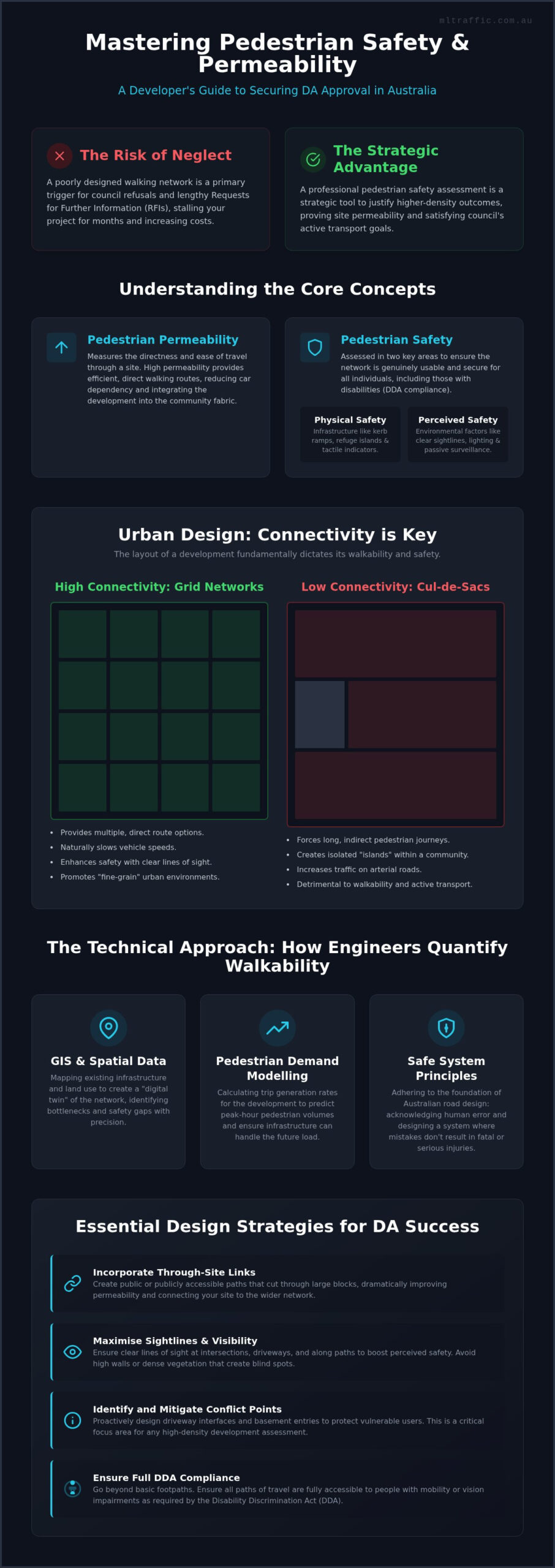
Permeability defines the directness and ease of travel through an urban network. In the context of an Australian development application, it measures how effectively a site allows pedestrians to move between destinations without unnecessary detours. High permeability reduces travel distances, making walking a viable alternative to driving. It’s a structural requirement that councils now scrutinise to ensure new developments don’t become isolated islands within the community.
Safety is categorised into two distinct areas: physical and perceived. Physical safety involves infrastructure like tactile ground surface indicators, refuge islands, and kerb ramps. Perceived safety relates to environmental factors like lighting, passive surveillance, and clear sightlines. If a path feels unsafe due to poor visibility, pedestrians won’t use it, regardless of its physical condition. A Walking audit is a standard tool used by engineers to identify these gaps during the design phase.
Australian councils have pivoted toward “active transport” as a primary planning goal to manage urban growth and reduce road congestion. This shift is formalised through the “Movement and Place” framework. This framework recognises that streets aren’t just for moving vehicles; they’re social spaces and destinations. A pedestrian safety assessment for development application must demonstrate that a project supports these dual functions by providing safe, high-quality walking environments that integrate with the existing streetscape.
The Core Principles of Urban Connectivity
Grid-based networks offer high connectivity because they provide multiple route options and clear lines of sight. In contrast, cul-de-sac layouts create low-connectivity environments that force pedestrians into long, circuitous paths to reach nearby services. Fine-grain urban design, characterised by smaller blocks and frequent intersections, improves safety by naturally slowing vehicle speeds and increasing pedestrian choice. Large “super-blocks” are often detrimental to walkability, as they create barriers that increase local traffic congestion by forcing all movement onto a few arterial roads.
Why Safety Assessments are Mandatory for Modern DAs
High-density developments inherently increase the risk of vehicle-pedestrian conflicts, particularly at driveway interfaces and basement entries. A pedestrian safety assessment for development application identifies these conflict points early, allowing for design interventions that protect vulnerable road users. Beyond basic safety, developers must ensure all paths meet the requirements of the Disability Discrimination Act (DDA). This ensures the network is accessible to everyone, including people with limited mobility or vision impairments. Prioritising these elements is the most effective way to reduce car dependency and satisfy council sustainability targets.
Technical Metrics: How Engineers Quantify Pedestrian Movement
Engineers use Geographic Information Systems (GIS) and spatial data to move beyond anecdotal claims about walkability. This evidence-based approach is central to a pedestrian safety assessment for development application. By mapping existing infrastructure and land use, we create a digital twin of the transport network to identify bottlenecks and safety gaps. This process identifies exactly where pedestrians are likely to move and where infrastructure is currently failing to meet demand.
Modelling pedestrian demand involves calculating the number of trips generated by a specific land use, such as a high-density residential tower or a commercial hub. We apply trip generation rates to determine peak-hour volumes and identify where these users will likely cross roads or access public transport. This data ensures the proposed infrastructure can handle the anticipated load without compromising safety. It’s a precise science that allows us to predict movement patterns before a single brick is laid.
All analysis adheres to “Safe System” principles, which are the foundation of Australian road design. This approach acknowledges that while humans make mistakes, the road system should be designed to prevent those mistakes from resulting in death or serious injury. Understanding the severity of these incidents through resources like Texas Brain Injuries reinforces why a data-driven pedestrian safety assessment for development application is crucial, replacing subjective opinions with hard metrics to provide a clear evidence base during council negotiations. It turns a potentially contentious debate into a factual discussion about network capacity and risk mitigation.
A “Pedshed” represents the actual area reachable from a site within a 5 or 10-minute walk, following the real path network. It doesn’t just use a simple “as-the-crow-flies” radius. We calculate the “Ratio of Walkability” by comparing the actual path distance to the straight-line distance. A low ratio indicates poor connectivity. Pedshed analysis is vital for identifying “severance” issues, where major barriers like arterial roads or rail lines isolate a development from local amenities.
Intersection Density and Route Directness
Network efficiency is measured through the Route Directness Index (RDI) and intersection density. A higher number of intersections per hectare generally indicates a more permeable and safer environment, as it provides more route choices and naturally reduces vehicle speeds. The RDI measures how much further a pedestrian must walk compared to the shortest possible distance. We use these metrics to justify site layouts to planning authorities, proving that a design maximises accessibility. For projects requiring detailed technical validation, our traffic engineering services provide the necessary modelling to support your application.
Integrating Pedestrian Safety into Your Traffic Impact Assessment
A Traffic Impact Assessment (TIA) is no longer exclusively focused on vehicle capacity and road delays. Modern planning requirements dictate that every TIA must incorporate a detailed pedestrian safety assessment for development application to ensure the proposed site integrates safely with the surrounding urban fabric. This integration involves mapping pedestrian desire lines and identifying potential conflict points where walking paths intersect with vehicle lanes.
Professional Traffic Engineering plays a vital role in validating safety claims through rigorous technical analysis. Engineers use this data to justify specific design choices, such as the placement of crossings or the width of footpaths. Demonstrating high permeability can also mitigate council concerns about vehicle traffic generation. If a development provides superior walking connectivity, it supports a modal shift away from private cars, which can lead to more favourable planning outcomes for higher-density projects.
A critical element of this process is the Sight Distance Assessment. These studies are essential for driveways and pedestrian crossings to ensure that drivers have an unobstructed view of people walking. Failing to provide adequate sight distance is a primary reason for DA refusal, as it poses an unacceptable safety risk under Australian Standards. It’s a technical requirement that must be addressed with precision to satisfy both safety protocols and council planners.
Meeting Council Development Control Plans (DCPs)
Navigating local government mandates for “Integrated Transport” requires a data-led approach. Most Australian councils have specific Development Control Plans (DCPs) that prioritise active transport over private vehicle use. A robust permeability report can be used to justify reduced on-site parking rates, as it proves residents or visitors have viable non-car alternatives. We ensure every design complies with Australian Standards for shared zones and footpath gradients to avoid costly RFIs during the assessment process. This alignment with local policy is essential for a streamlined approval path.
Mitigating External Traffic Impacts
Network analysis is used to prove that a development won’t over-burden existing footpaths or public transport infrastructure. We identify where off-site infrastructure contributions, such as new pedestrian refuges or signalised crossings, are necessary to maintain safety levels. This analysis also addresses the “last mile” connection to public transport hubs. Ensuring a seamless path from the site to the nearest train station or bus stop is a core requirement for securing approval in high-growth corridors. Proving these connections are safe and direct reduces the perceived impact of the development on the broader community.
Design Strategies to Maximise Permeability and Safety
Practical design is where a pedestrian safety assessment for development application moves from theory to implementation. Effective site layouts prioritise movement through specific interventions that reduce risk while enhancing the user experience. Key design strategies include:
- Implementing through-site links to break up large development blocks and reduce detour distances.
- Installing raised pedestrian crossings at high-conflict driveway interfaces to slow vehicles.
- Prioritising passive surveillance through active frontages rather than physical barriers.
- Providing clear, unobstructed sightlines at all entry and exit points for both drivers and walkers.
Optimising On-Site Pedestrian Circulation
Pedestrians naturally follow “desire lines”, taking the most direct path between two points. If a site layout ignores these paths, users will often take unsafe shortcuts through car parks or across garden beds. Integrating pedestrian paths with professional Car Park Design is essential to separate vulnerable road users from vehicle movements. All paths must include tactile ground surface indicators and high-output lighting to ensure compliance with Australian Standards and the Disability Discrimination Act (DDA). These elements are non-negotiable for securing DA approval.
Stitching the Site into the External Network
A successful development must function as part of the existing urban fabric. This requires multiple entry and exit points around the site perimeter to ensure pedestrians aren’t forced into long detours. Collaborating with adjacent landowners to create continuous corridors can significantly improve local walkability and reduce the impact of “dead ends”. Improving connectivity to local retail centres and public transport hubs is a core requirement for modern applications. If you need a technical review of your site layout, contact our senior engineers to ensure your design meets all regulatory requirements.
Expert Pedestrian Analysis for Your Development Application
ML Traffic Engineers Australia provides specialised pedestrian safety reports that bridge the gap between architectural vision and regulatory compliance. Every pedestrian safety assessment for development application we produce is grounded in 15+ years of Australian consultancy experience. We don’t just identify movement constraints; we provide technical solutions that satisfy council planners while maintaining the commercial viability of your site layout. Our reports are designed to withstand the scrutiny of local government authorities and state planning panels.
A key component of our analysis is the integration of network data with Swept Path Analysis. This allows us to precisely model the interaction between heavy vehicles, such as service or waste collection trucks, and vulnerable road users. By identifying these conflict points in the digital design phase, we prevent safety failures that could lead to liability issues or DA refusal. Dealing directly with senior principals ensures that these technical nuances are communicated effectively to planning authorities during complex negotiations.
Our no-nonsense approach is critical for navigating planning bureaucracies. We focus on the facts, using data-driven evidence to justify site permeability and safety measures. This removes subjectivity from the assessment process and provides a clear path to approval. Whether your project is a high-density residential tower or a large-scale industrial facility, our pedestrian safety assessment for development application ensures your transport network is safe, compliant, and efficient.
Our Methodology for Permeability and Safety Reports
Our process is structured to provide maximum technical rigour. It begins with a comprehensive site audit to evaluate existing infrastructure, lighting, and pedestrian desire lines. We then use spatial modelling to simulate how your development will alter movement patterns in the local area. Finally, we conduct a safety risk assessment to ensure all proposed paths meet Australian Standards and local council guidelines. This structured approach allows us to develop robust, evidence-based arguments that support your proposed site layout during the RFI process.
The ML Traffic Engineers Australia Advantage
We operate with a “no-gatekeepers” philosophy. The senior principal who initiates your project is the same expert who performs the technical work and signs off on the final report. This continuity ensures accountability and deep technical insight at every stage of the planning process. With experience across all land-use types, including residential, commercial, and industrial, we understand the specific bureaucratic requirements of local councils. For a professional assessment that streamlines your approval path, contact our experts today.
Securing Your DA Approval Through Robust Pedestrian Planning
Successfully navigating the Australian planning system requires a shift from vehicle-only modelling to integrated transport design. A comprehensive pedestrian safety assessment for development application is the most effective way to prove that your project enhances local permeability and safety. By using the technical metrics discussed, such as Pedshed analysis and Route Directness Indexing, you replace council subjectivity with hard data. This approach ensures compliance with Australian Standards and supports strategic arguments for higher-density outcomes by proving the network can support increased foot traffic.
ML Traffic Engineers Australia provides national coverage across all Australian jurisdictions, bringing 15+ years of specialised engineering experience to every project. We offer a no-gatekeepers approach where senior principals perform all technical work personally. This direct involvement is critical for resolving complex transport planning negotiations and securing streamlined approvals. Consult with our senior traffic engineers on your pedestrian safety assessment to ensure your site layout is safe, efficient, and fully compliant. We look forward to helping you achieve a successful planning outcome.
Frequently Asked Questions
What is the difference between permeability and connectivity in transport planning?
Connectivity refers to the total number of nodes and links within a transport network. Permeability is the extent to which that network allows for direct and easy travel between various destinations. While a site can have many physical connections, it isn’t permeable if those routes are circuitous or blocked by barriers. Engineers use these metrics to assess the efficiency of a proposed street layout during the planning phase.
How is pedestrian permeability measured in a Traffic Impact Assessment?
Engineers use the Route Directness Index (RDI) and Pedshed analysis to quantify permeability levels. The RDI compares the actual walking distance against the straight-line distance to determine network efficiency. A ratio of 1.5 or less is typically considered acceptable by most councils. These technical metrics are integrated into a broader Traffic Impact Assessment to prove that a development supports active transport and integrates with the existing urban fabric.
Why do Australian councils require a pedestrian safety assessment for new DAs?
Councils require a pedestrian safety assessment for development application to ensure new projects adhere to “Movement and Place” frameworks and the Safe System approach. These assessments identify potential conflict points between vehicles and vulnerable road users before construction begins. Demonstrating a safe walking environment is a mandatory requirement for high-density developments to mitigate the risks associated with increased foot traffic, complex driveway interfaces, and basement car park entries.
Can high pedestrian permeability reduce the number of car parking spaces required?
Proving superior pedestrian permeability can often justify a reduction in on-site parking rates. If a development is highly accessible and well-connected to public transport hubs, councils may accept lower parking provision based on reduced car dependency. This argument must be supported by a professional Car Parking Demand Assessment and evidence-based data showing that walking is a viable alternative for future residents, which can significantly lower construction costs.
What is a pedshed analysis and how does it affect my site design?
A pedshed analysis maps the actual area reachable within a 5 or 10-minute walk from a site using the real path network. It identifies physical barriers like rail lines or arterial roads that cause “severance”. If the analysis shows poor catchment area coverage, engineers will suggest design changes such as through-site links or new crossing points to improve accessibility and satisfy the walkability requirements found in local planning codes.
How does pedestrian safety impact the commercial value of a development?
Safe and permeable environments increase commercial value by creating “active frontages” and higher foot traffic for retail tenants. Pedestrians are more likely to visit and stay in areas that feel safe, well-lit, and easy to navigate. High-quality walking networks also improve the marketability of residential developments, as proximity to amenities and safe access to public transport are primary drivers of property demand in Australian urban centres.
What are “through-site links” and when are they mandatory?
Through-site links are dedicated public paths that cut through a private development block to improve local connectivity. They are often mandatory for large “super-blocks” where the existing street network is fragmented. Councils use Development Control Plans (DCPs) to trigger these requirements, ensuring that new developments don’t become gated islands that force pedestrians into long detours. These links must comply with Australian Standards for lighting, width, and accessibility.
How can a traffic engineer help improve the permeability of my project?
A traffic engineer provides technical modelling to identify gaps in your site’s movement network. We use spatial data to simulate pedestrian desire lines and recommend layout changes that balance vehicle access with walking safety. By conducting a pedestrian safety assessment for development application early in the design phase, we help you avoid costly RFIs. Our senior principals personally perform this work to ensure your project meets the strict requirements of Australian planning authorities.

Disclaimer
The content on www.mltraffic.com.au, including all technical articles, guides, and resources, is provided for general informational and educational purposes only. It is not intended to constitute professional advice in traffic engineering, transportation planning, development approvals, or any other technical or legal field.
While ML Traffic Engineers makes every reasonable effort to ensure the accuracy, completeness, and timeliness of the information published, we do not provide any warranties or representations (express or implied) regarding its reliability, suitability, or availability for any particular purpose. Any reliance you place on the content is strictly at your own risk.
In no event shall ML Traffic Engineers, its directors, employees, authors, or affiliates be liable for any direct, indirect, incidental, special, consequential, or punitive damages (including, without limitation, loss of profits, data, or business opportunities) arising out of or in connection with the use of, or inability to use, any information provided on this website.
The articles and guides on this site are not a substitute for engaging a qualified, registered professional traffic engineer (such as an NPER or RPEQ engineer) to assess your specific project requirements. For tailored advice, compliance assessments, or traffic engineering services, please contact a competent professional.
This disclaimer may be updated from time to time without notice. By accessing or using this website, you agree to be bound by the most current version of this disclaimer.
