
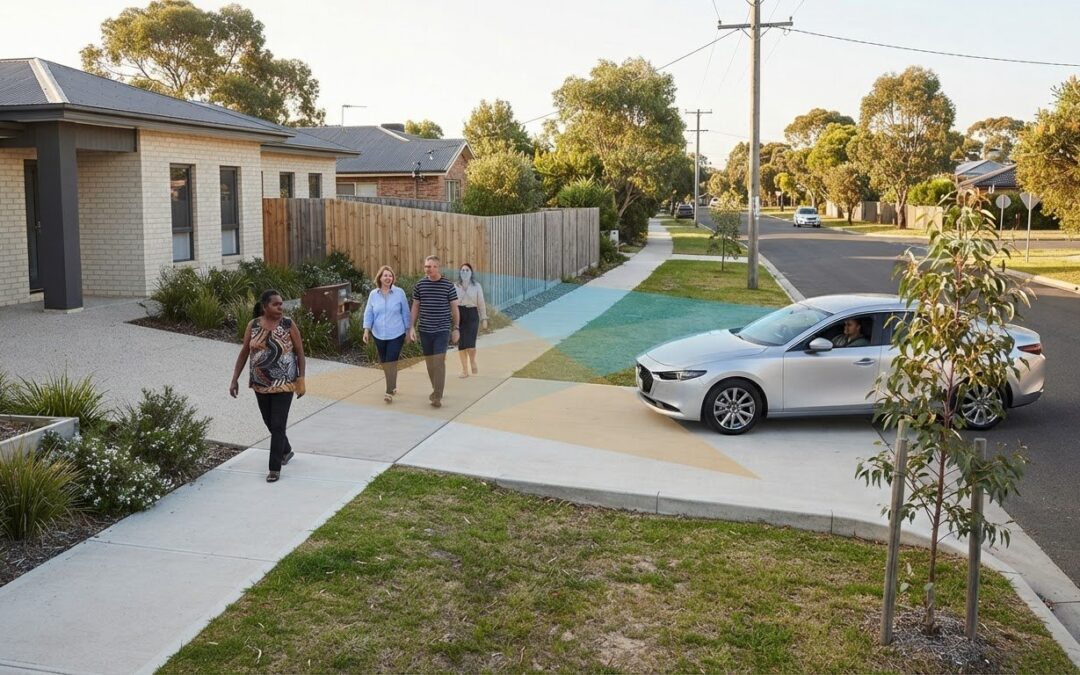
What needs to be assessed to show pedestrians and drivers can see each other near a proposed driveway or access? A pedestrian sight distance assessment tests the sight lines created by the development, rather than relying on whether an access looks clear on a plan.
An overlooked visibility issue can lead to design changes or complicate a planning review. A project-specific assessment identifies where vehicle and pedestrian movements may interact, what site conditions affect visibility and where design refinement may be needed. Its findings give the project team a clear technical basis for decisions and review.
This checklist explains which sight lines and movements may need attention, how access layout and visibility obstructions affect the assessment, and what project information helps make the analysis clear. The assessment should reflect applicable Austroads guidance and project-specific authority requirements, not assumptions that may not fit the site.
Key Takeaways
- A pedestrian sight distance assessment should reflect the site layout, relevant user movements and applicable guidance, rather than rely on a generic sight-line assumption.
- Define the scope, map pedestrian and vehicle movements, inspect visibility, assess potential interactions and document the findings.
- Access geometry, boundary treatments and landscaping can affect visibility. Treat example layouts as illustrative, not as compliance rules.
- Prepare clear plans, access details, pedestrian routes and site observations to support a focused assessment.
- Where visibility is constrained or movements are complex, technical findings can guide design refinement and development application documentation.
What a pedestrian sight distance assessment checks at a development site
Pedestrian sight distance is the visibility available between relevant road users at a location, considered in relation to their movements and opportunity to respond. There is no single distance that applies to every development. The sight lines to assess depend on the site layout, access arrangement, user positions, movement patterns and applicable design guidance.
A pedestrian sight distance assessment examines whether drivers and pedestrians can see one another where their paths may meet. It focuses on visibility at specific locations, not every possible view across a site. This is different from a road safety audit, which has a broader road safety review scope, and a traffic impact assessment, which considers a development’s traffic effects. The disciplines may inform the same project, but they answer different questions.
Where sight distance matters around a development
Start with places where pedestrian and vehicle paths meet or run close together. These may include vehicle access points, crossings, internal driveways and pedestrian routes. Also consider reversing areas, loading interfaces and car park circulation where visibility may be restricted.
Check what could obstruct or narrow a sight line, including boundary walls or fences, landscaping, parked vehicles and built form. For example, a planting bed near a driveway might affect a driver’s view of a footpath. This is an issue to investigate, not a universal compliance rule. Road geometry also affects what is visible, as explained in this overview of sight distance in road design.
Which users and movements belong in the assessment?
Map the relevant movements before deciding which sight lines to assess. These may include drivers entering or leaving the site, pedestrians walking past an access, and people crossing vehicle paths inside the development. Base the assessment on the actual access arrangements and expected site activity, rather than assuming every development has the same interactions.
- Where does a vehicle cross a footpath or pedestrian route?
- Could a driver’s view be restricted when entering, leaving or reversing?
- Which pedestrian approaches and crossing movements are relevant?
- Do loading or other site activities create additional points of interaction?
The assessment scope should reflect the project’s movements and the guidance or requirements that apply to the site. A clear technical assessment records the locations and user positions considered, visibility constraints identified and basis for its findings. This gives the project team useful evidence for design decisions without treating one sight distance as suitable for every context.
How sight distance and pedestrian-vehicle interaction risks are assessed
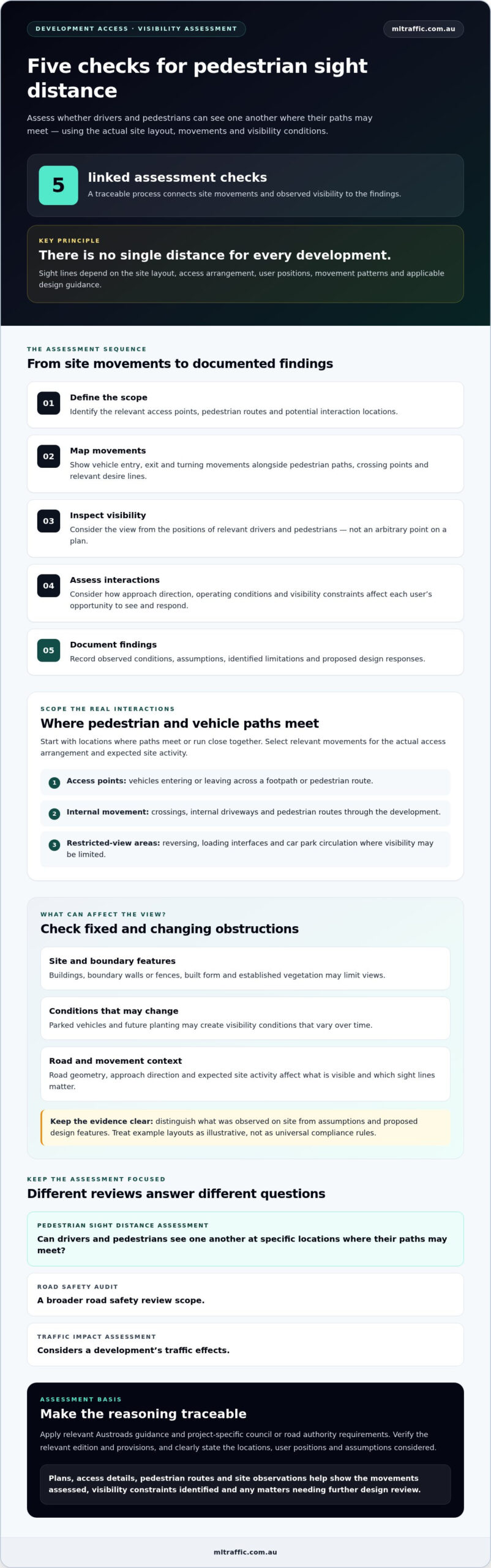
A defensible assessment follows a traceable process. It connects project movements and observed visibility conditions to the findings, while distinguishing existing site conditions from proposed design features. The report should make clear what was assessed, which assumptions were applied and where further design review may be needed.
- Define the scope. Identify the access points, pedestrian routes and potential interaction locations relevant to the project.
- Map movements. Show vehicle entry, exit and turning movements alongside pedestrian paths, crossing points and relevant desire lines.
- Inspect visibility. Consider the view from the positions of relevant drivers and pedestrians, not an arbitrary point on a plan.
- Assess interaction risks. Consider how approach direction, operating conditions and visibility constraints affect users’ opportunity to see and respond to one another.
- Document findings. Record observed conditions, assumptions, identified limitations and proposed design responses.
Map movements before drawing sight lines
Plans should make potential conflict locations easy to understand. For example, show where a vehicle turning out of an access crosses a footpath, as well as the pedestrian approach that may meet it. A site visit or relevant site information can help distinguish actual conditions from features shown on design drawings. Observation points and sight lines should match the movements being assessed, such as a driver’s position when approaching an exit and a pedestrian’s position along the route.
Check visibility conditions and document the risk
Review both fixed and changeable obstructions. Buildings, boundary structures and established vegetation may limit views; parked vehicles or future planting may create conditions that vary over time. Describe the scenario being assessed, including approach direction, expected site activity and any speed assumptions used. Don’t present an assumption as a site observation.
Separate proposed mitigation from existing visibility conditions. A design response, such as changing an access layout or adjusting a boundary treatment, should be identified as a proposal and assessed for its intended effect. Note limitations or matters requiring further review rather than implying a proposed measure has already resolved them.
Apply relevant guidance and acceptance criteria only after considering the project context and the requirements of the responsible council or road authority. Austroads provides road design guidance, including material on pedestrian sight distance requirements. Verify the relevant edition and provisions for the assessment. The reference alone does not establish a universal criterion for every site.
A project-specific pedestrian sight distance assessment brings movement, visibility and design findings together to support development decisions. ML Traffic Engineers Australia provides traffic engineering services including sight distance assessment, connecting site evidence with clear technical findings.
What changes the assessment: design, users and operating conditions
A clear view on a plan does not necessarily reflect what users can see on site. Access geometry, nearby development features and expected movements during operation all influence which sight lines need review. The examples below are illustrative only. They do not establish compliance criteria or a universal design rule.
How site layout and obstructions affect visibility
Review the access position and driveway alignment in relation to the road environment and nearby pedestrian paths. A driveway that meets a footpath at an angle may create different views from one that meets it more directly. Check proposed boundary treatments and landscape plans as well as existing conditions. Fences, walls, planting, signs, street furniture and parked vehicles can interrupt views or conceal approaching users.
Design changes may preserve or improve sight lines, but their effect should be assessed in context. A lower or more open boundary treatment may reduce one obstruction, while a revised access position may change where pedestrian and vehicle paths intersect. Consider the design as a whole, including whether landscaping or site activity could alter visibility over time.
| Condition | Potential visibility effect | Assessment response |
|---|---|---|
| Open view at an access | Users may have a clearer view of approaching movements. | Check the relevant positions and paths; don’t assume an open view alone demonstrates suitability. |
| Wall, fence or building near a driveway | May restrict a driver’s or pedestrian’s view near the point of interaction. | Record the obstruction and assess the sight line from the relevant user position. |
| Planting, signage or parked vehicles | May create partial or changing obstructions. | Consider the proposed layout and realistic operating conditions; identify any assumptions. |
How user and operating scenarios change the review
The review should reflect the site’s expected operation, not a standard pattern applied to every development. Consider which pedestrian routes are likely to be used and how vehicles enter, leave or turn across them. Queuing can affect the view available to a following driver; reversing or loading may create a different interaction point from forward vehicle movements.
Speed assumptions can influence the scenario being assessed, so don’t insert an unsupported value. Identify relevant inputs and verify them against project information and applicable council or road authority requirements. A project-specific pedestrian sight distance assessment should distinguish observed site conditions from assumptions about future use, then explain how each affects the findings. This helps the project team understand why a particular sight line matters and whether a proposed design response addresses the identified condition.
Pedestrian sight distance assessment checklist for project teams
Organise project information before the assessment begins. A current, coordinated plan set shows how access, pedestrian routes and site features relate to one another. It also makes gaps in the available information easier to identify before findings are documented.
Information to assemble before assessment
- Current site plans: Show property boundaries, buildings, vehicle access points, internal driveways, pedestrian paths, crossings and proposed landscaping.
- Road and access details: Provide relevant information about the adjoining road, driveway alignment and access arrangement.
- Proposed use and movements: Describe expected site activity and relevant vehicle and pedestrian movements, including turning, loading or reversing where applicable.
- Site evidence: Include available photographs or survey information to clarify levels, structures, vegetation and other visibility constraints.
- Design context: Identify proposed boundary treatments, signs, planting and other features that may affect sight lines.
Use information that reflects the current design. If plans show different access layouts or landscaping schemes, identify which option the assessment is based on. This keeps the scope and findings tied to a defined proposal.
Checks to complete before documenting findings
Before finalising the assessment, check that sight lines correspond to relevant user positions and movement paths. Distinguish existing conditions from proposed features, and note whether an obstruction is temporary, outside the project boundary or expected to change. Record limitations where the available plans or site evidence do not clearly establish a condition.
- Are the assessed vehicle and pedestrian movements shown clearly on the plans?
- Do the observation points reflect where the relevant users would be positioned?
- Are visibility constraints identified and linked to the relevant sight lines?
- Are proposed design responses distinguished from observed site conditions?
- Are the assessment’s assumptions, information sources, limitations and criteria stated?
- Have the applicable Austroads guidance and project-specific council or road authority requirements been checked?
Select criteria for the project context, rather than treating them as automatically applicable because they appear in a general reference. Record the guidance and requirements used, including relevant editions or provisions, and explain any unresolved constraints or design actions. A clear record supports informed design and planning decisions, but does not guarantee approval.
ML Traffic Engineers prepares project-specific pedestrian sight distance assessments that set out the scope, evidence and findings. Arrange a sight distance assessment for your project.
When a traffic engineer can help with a sight distance assessment
Technical input is useful when a proposed access has restricted views, the layout creates several pedestrian and vehicle interaction points, or vehicle movements are complex. A driveway close to a crossing, for example, may need more careful review than a simple access with clear sight lines. The project layout, expected movements and applicable authority requirements determine the assessment scope.
A traffic engineer can assess the sight lines relevant to the site, identify visibility constraints and explain how they relate to the proposed design. The findings can inform design refinement before plans are finalised and provide technical information for a development application. This is project-specific analysis, not a guarantee that a council or road authority will approve the proposal.
How findings support development design and review
Assessment findings help the project team understand where a design may need adjustment or further investigation. Depending on the site, this could involve reviewing access positioning, boundary treatments or the relationship between vehicle paths and pedestrian routes. The report can also sit alongside access and broader traffic assessment material where those matters overlap. For more detail on related traffic engineering services, see the relevant service information.
A sight distance review answers a focused visibility question. A broader traffic impact assessment considers other project-related traffic matters, such as the effects of development traffic on the surrounding network. The scope should make clear which questions the assessment addresses and how its findings relate to wider design and planning documentation.
What to expect from a project-specific assessment
A clear assessment sets out its scope, the project information relied on, the relevant movements and sight lines considered, and the approach used to reach its findings. It distinguishes site observations from design assumptions, identifies limitations and records proposed responses that need further review. ML Traffic Engineers Pty Ltd has more than 15 years of traffic engineering and transport planning experience.
Where the access design or site context raises unresolved visibility questions, a pedestrian sight distance assessment can connect technical evidence with practical project decisions. Explore ML Traffic Engineers Pty Ltd’s traffic engineering services to discuss an assessment for your project.
Make visibility a considered part of your development design
A clear sight distance assessment connects site conditions with the movements that matter. Assess relevant sight lines from appropriate user positions, identify obstructions and document the assumptions, guidance and criteria used. This evidence can help the project team understand where design refinement or further review may be needed.
A pedestrian sight distance assessment is project-specific. Access layout, pedestrian routes, expected activity and operating conditions all shape the review. A well-documented assessment can support development design and planning decisions, but it does not guarantee approval from a council or road authority.
ML Traffic Engineers Pty Ltd provides sight distance assessments as part of its traffic engineering services, alongside Traffic Impact Assessments, Vehicle Swept Path Analysis and car park design. If your project has constrained visibility or complex vehicle and pedestrian movements, discuss a project-specific pedestrian sight distance assessment.
Frequently Asked Questions
What is a pedestrian sight distance assessment?
A pedestrian sight distance assessment examines whether relevant pedestrians and drivers can see one another where their movements may interact. It identifies the sight lines that matter for a particular development, such as at a driveway crossing a footpath. The assessment considers site layout, user positions, obstructions and applicable guidance. It does not apply one standard distance to every site; findings should relate to the project’s conditions and scope.
When is a pedestrian sight distance assessment needed?
A pedestrian sight distance assessment may be needed when development vehicles cross a footpath, pedestrian routes intersect with internal driveways, or access visibility is restricted. It can also be useful where turning, queuing or reversing creates several possible interaction points. The need and scope depend on the project and relevant council or road authority requirements. A project-specific review can identify visibility issues early enough to inform design and application documentation.
How is pedestrian sight distance assessed at a driveway?
At a driveway, the assessment identifies relevant vehicle and pedestrian movements, then considers visibility from positions that reflect how users approach and cross the access. The review examines the driveway layout, nearby road and path conditions, and potential obstructions. It records the assumptions and criteria used, along with visibility constraints or proposed design responses. Applicable guidance and authority requirements should be checked for the specific project.
What can obstruct pedestrian sight lines near a vehicle access?
Common potential obstructions include boundary walls and fences, buildings, vegetation, signs, street furniture and parked vehicles. Their effect depends on where they sit in relation to the access, pedestrian route and relevant user positions. Some obstructions are permanent; others may change with parking, planting or site activity. An assessment should identify the conditions considered and distinguish existing features from proposed or temporary ones.
Do Australian standards set one pedestrian sight distance for every development?
No single sight distance should be assumed to apply to every development. The relevant assessment criteria depend on the movement being considered, site context, applicable road design guidance and project-specific council or road authority requirements. AS 2890 may be relevant to aspects of parking and access design, but its relevance should be checked against the assessment scope. Confirm the applicable documents, editions and provisions before stating compliance.
What information is needed for a pedestrian sight distance assessment?
Useful information includes current site plans showing boundaries, buildings, vehicle access, pedestrian routes and landscaping. Provide relevant road and access details, the proposed use, and expected vehicle and pedestrian movements. Available photographs or survey information may also help describe site conditions. The assessment should identify its information sources, assumptions, limitations and criteria, so readers can understand how the findings relate to the proposed design.
Can landscaping affect a pedestrian sight distance assessment?
Yes. Planting can obstruct or narrow a sight line, particularly near a driveway or where pedestrians cross vehicle paths. The assessment should consider existing vegetation as well as proposed landscaping, including how the design may affect visibility as plants grow. Findings can inform changes to planting locations or other design details, but the response should be assessed in context. Don’t treat a general example as a compliance rule for every site.

Disclaimer
The content on www.mltraffic.com.au, including all technical articles, guides, and resources, is provided for general informational and educational purposes only. It is not intended to constitute professional advice in traffic engineering, transportation planning, development approvals, or any other technical or legal field.
While ML Traffic Engineers makes every reasonable effort to ensure the accuracy, completeness, and timeliness of the information published, we do not provide any warranties or representations (express or implied) regarding its reliability, suitability, or availability for any particular purpose. Any reliance you place on the content is strictly at your own risk.
In no event shall ML Traffic Engineers, its directors, employees, authors, or affiliates be liable for any direct, indirect, incidental, special, consequential, or punitive damages (including, without limitation, loss of profits, data, or business opportunities) arising out of or in connection with the use of, or inability to use, any information provided on this website.
The articles and guides on this site are not a substitute for engaging a qualified, registered professional traffic engineer (such as an NPER or RPEQ engineer) to assess your specific project requirements. For tailored advice, compliance assessments, or traffic engineering services, please contact a competent professional.
This disclaimer may be updated from time to time without notice. By accessing or using this website, you agree to be bound by the most current version of this disclaimer.
