
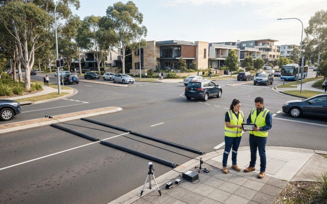
A development application often hinges entirely on the credibility of its baseline data; get the initial counts wrong, and the planning process grinds to an abrupt halt. Selecting an appropriate, defensible traffic survey methodology for development applications is the single most reliable way to eliminate costly Requests for Further Information (RFIs) before assessment officers evaluate your proposal.
We understand how frustrating it is when technical reports face administrative pushback. Council engineers routinely reject submissions due to obsolete counting methods, data captured during unrepresentative school holiday periods, or inflated survey scopes that balloon budgets without adding statutory value. You shouldn’t have to risk months of avoidable delays over baseline counting errors.
In this guide, you’ll master the survey techniques, timing parameters, and Austroads-aligned data standards required to secure straightforward council approvals across Australia. Here is how to establish an airtight survey scope that reliably supports your overall Traffic Impact Assessment from day one.
Key Takeaways
- Scoping an appropriate traffic survey methodology for development applications ensures defensible baseline data, preventing statutory delays and costly Requests for Further Information (RFIs).
- Matching counting techniques, from pneumatic automatic tube counters to high-definition video analytics, to specific land-use classes prevents budget blowouts from over-scoping.
- Scheduling data collection during neutral operational periods guarantees that captured baseline volumes reflect genuine network peak demand rather than holiday or weather distortions.
- Translating raw field counts into calibrated SIDRA models directly supports robust, council-ready Traffic Impact Assessment submissions.
- Retaining certified engineering specialists protects development timelines against the regulatory risks of unverified or outdated traffic datasets.
Understanding Traffic Survey Requirements for Development Applications
A rigorous traffic survey methodology for development applications establishes the factual baseline of road network operations surrounding a proposed site. Council assessment engineers scrutinise this initial data to determine whether local roads can safely accommodate projected traffic volumes. When applicants submit inaccurate, outdated, or incomplete baseline data, consent authorities issue formal Requests for Further Information (RFIs). An RFI halts statutory determination clocks, adding months of holding costs and delaying financing approvals. Securing first-time planning consent requires empirical survey data that withstands technical cross-examination.
Field data collection methods must align with council audit protocols to prevent costly evidentiary disputes. To understand the field mechanics behind standard data collection, watch this training demonstration:
The Role of Empirical Baseline Data in Council Approvals
Council planning officers regularly reject applications that rely on desktop estimates or aged public databases. Historical counts fail to account for recent local developments, shifting freight corridors, or altered post-pandemic commuting trends. Conducting site-specific field counts through established traffic count methodologies provides an indisputable record of existing traffic volumes, turning movements, and road capacity. Defensible baseline counts neutralise subjective community objections and prevent protracted disputes during the assessment cycle.
Statutory Standards and Relevant Engineering Guidelines
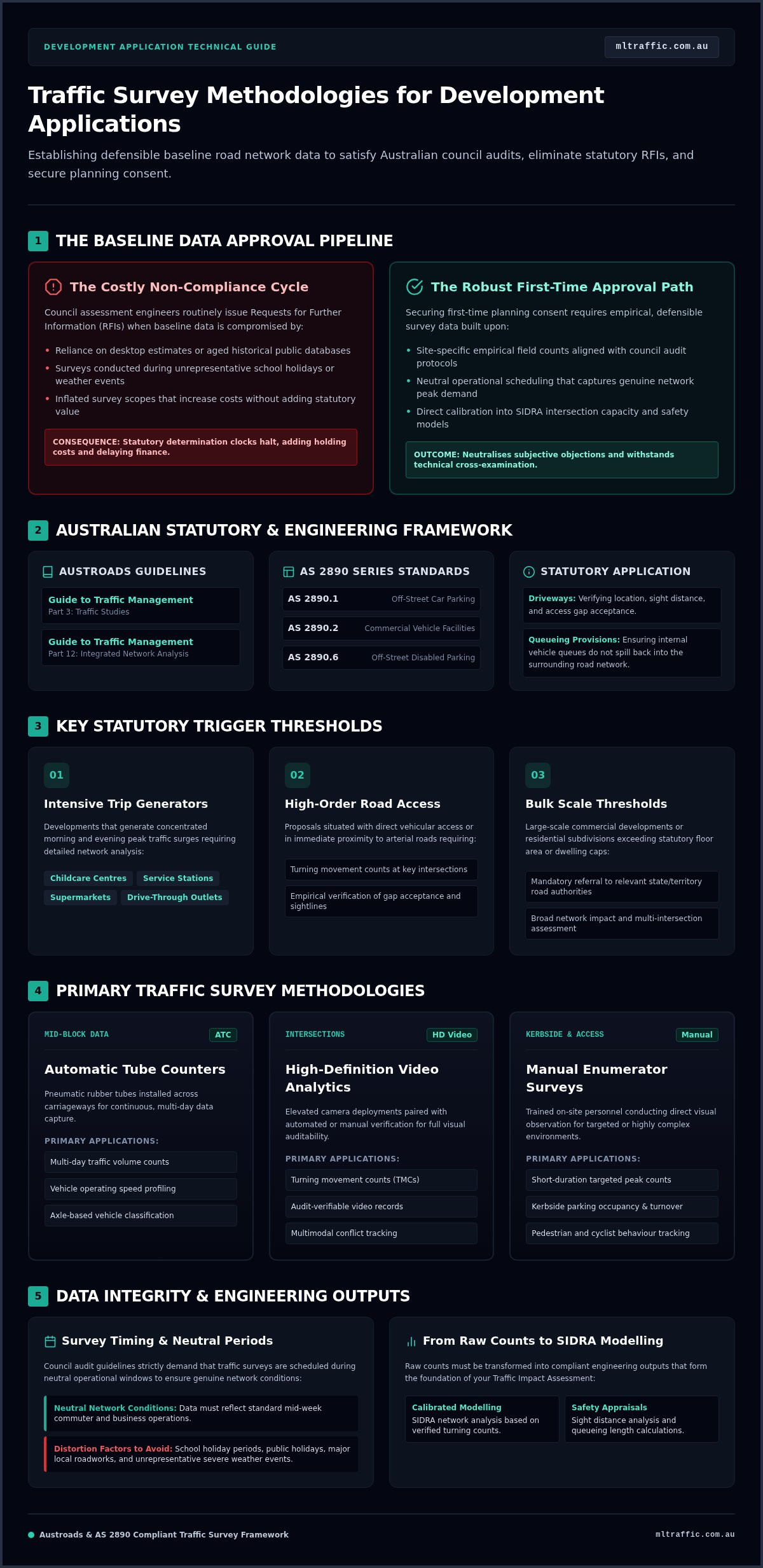
Engineering compliance demands strict conformity with national transport standards. Field surveys must align with the Austroads Guide to Traffic Management (specifically Part 3 for traffic studies and Part 12 for integrated network analysis). In addition, access driveway locations, queueing provisions, and off-street layouts must satisfy the AS 2890 series (Parts 1, 2, and 6). Embedding these verified standards within a professional Traffic Impact Assessment ensures the resulting intersection capacity calculations and safety analyses meet statutory expectations.
Key Trigger Thresholds Demanding Formal Traffic Data
Australian planning schemes stipulate precise statutory thresholds that demand formal traffic surveys. Key triggers include:
- Intensive trip generators: Developments that generate substantial morning and evening peak traffic, such as childcare centres, service stations, supermarkets, and drive-through food outlets.
- Access onto high-order roads: Proposals with direct vehicular access or immediate proximity to arterial roads, requiring intersection turning movement counts to verify gap acceptance.
- Bulk scale thresholds: Commercial or residential subdivisions exceeding statutory floor area or dwelling counts that trigger mandatory referral to relevant road authorities.
Primary Traffic Survey Methodologies Applied in Development Planning
Selecting an effective traffic survey methodology for development applications requires matching data capture instruments to specific development impacts. Deploying incorrect equipment leads to invalid datasets or excessive preliminary expenditure. Whether evaluating mid-block capacity, intersection performance, or kerbside activity, engineers rely on three proven data collection mechanisms to satisfy Australian consent authorities.
- Automatic Tube Counters (ATC): Deployed for multi-day mid-block speed, volume, and axle-based vehicle classification.
- High-Definition Video Analytics: Deployed at intersections for audit-verifiable turning movement counts and multimodal conflict tracking.
- Manual Enumerator Surveys: Deployed for short-interval parking accumulation, queue length verification, and active transport movement.
Intersection Turning Movement Surveys (TMCs)
Intersection counts quantify turn-by-turn vehicle movements through critical junctions surrounding a site. While manual enumerators were once standard, high-mast video cameras equipped with computer-vision analytics now represent the industry benchmark. Video capture delivers continuous visual records that council assessment officers can verify during application audits. Detailed turning volumes, split by heavy vehicle classes and light passenger cars, provide the direct inputs required for SIDRA Intersection capacity modelling. As international planning standards and government transport assessment guidance demonstrate, transparent junction flow records form the backbone of defensible traffic engineering submissions.
Automatic Tube Counters and Continuous Volume Profiling
Pneumatic tube counters measure mid-block traffic conditions along frontage roads. Twin-tube configurations register air pulses generated by vehicle axles, recording directional volume, travel speeds, and headway spacing. Council engineering guidelines typically mandate a 7-day continuous counting period (168 consecutive hours) to determine valid Average Annual Daily Traffic (AADT) and 85th percentile operating speeds. This dataset classifies traffic under the Austroads 12-class vehicle classification system, pinpointing commercial freight percentages that dictate required pavement structures and sight line geometry.
Parking Occupancy and Turnover Methodology
Precinct parking studies establish whether surrounding kerbside spaces can absorb overflow demand. Beat surveys record spatial occupancy and duration of stay at fixed intervals (typically 15 to 30 minutes) across peak periods. Quantifying existing parking deficits or surplus capacity directly informs a statutory Car Parking Demand Assessment. If your development proposal involves variations to standard council parking rates or complex access arrangements, engaging experienced specialists for an Intersection Analysis or complete technical assessment ensures all survey scopes align precisely with local assessment criteria.
Survey Planning Parameters: Timing, Duration, and Spatial Boundaries
Council assessment officers rigorously audit the boundary conditions of every survey program. When spatial limits are scoped too narrowly, council will reject the baseline for omitting impacted intersections. Conversely, surveying expansive road networks beyond statutory needs wastes client capital. Scoping an appropriate traffic survey methodology for development applications requires strict adherence to spatial thresholds and neutral counting windows.
Identifying Network Peaks vs Development Generation Peaks
Survey schedules must reconcile background network peaks with development-specific peak activity. While commuter peaks typically concentrate between 7:00 AM-9:00 AM and 4:00 PM-6:00 PM on weekdays, specific land uses deviate significantly. Bulky goods retail, medical centres, and commercial recreational facilities often generate their highest trip volumes outside commuter peaks, such as Saturday mid-morning windows between 11:00 AM and 2:00 PM. Capturing data across both network and site peaks ensures analytical models evaluate the true worst-case operational scenario.
Exclusion Periods and Seasonal Normalisation
Consent authorities enforce non-negotiable timing exclusions to guarantee baseline data represents typical operating conditions. Fatal timing flaws that cause immediate council rejection include:
- School holidays and public holidays: School term breaks fundamentally alter commuter patterns, artificially suppressing arterial volumes and turning counts.
- Shoulder weekdays: Mondays and Fridays exhibit irregular hybrid working and freight volumes. Data collection must focus on Tuesdays, Wednesdays, and Thursdays.
- Adverse weather conditions: Severe rainfall reduces baseline traffic volumes by 10% to 12%, distorting standard vehicle headway and speed distributions.
- Road network disruptions: Temporary detours, utility works, or nearby construction invalidate local flow baselines.
When unexpected disruptions occur during fieldwork, engineers must normalise the counts. Validating short-term data against nearby permanent state monitoring stations allows practitioners to apply defensible seasonal correction factors that satisfy council scrutiny.
Determining the Extent of the Traffic Study Network
The survey study area-the “zone of influence”-depends on projected trip volumes. Planning authorities apply the standard 5% rule of thumb. Any intersection or road segment where development-generated traffic increases baseline volumes by 5% or more must be surveyed. Furthermore, if an adjacent intersection already operates at poor performance levels (Level of Service E or F), it must be incorporated into the survey footprint regardless of percentage impact. Aligning spatial boundaries with recognised traffic engineering guidelines ensures comprehensive coverage without incurring excessive surveying costs.
Transforming Survey Data into Compliant Traffic Engineering Outputs
Collecting raw figures represents only the initial phase of the approval process. The true technical value lies in synthesising those field counts into calibrated, council-ready planning deliverables. A robust traffic survey methodology for development applications bridges the gap between field observation and statutory assessment by converting raw counts into standardised Passenger Car Units (PCUs), applying heavy vehicle equivalencies, and establishing transparent baseline networks.
Calibration of Intersection Capacity and Network Models
Field counts directly populate analytical software engines, primarily SIDRA INTERSECTION. Empirical field data calibrates computer models against real-world operations by matching observed queue lengths and gap-acceptance behaviour with software outputs. Assessing key performance metrics confirms whether an intersection functions within regulatory limits:
- Degree of Saturation (DOS): Measures the ratio of traffic volume to theoretical capacity. Signals and roundabouts approaching 0.85 to 0.90 alert assessment officers to imminent operational failure.
- Level of Service (LOS): Grades overall intersection performance from LOS A (free flow) to LOS F (forced flow with severe congestion and excessive delays).
- Average Delay: Pinpoints movement-specific delays in seconds per vehicle, identifying failing right-turn pockets.
Establishing Existing Baseline vs Post-Development Scenarios
Council assessment officers require clear distinctions between existing conditions and future operations. Engineers superimpose estimated development trip generation onto surveyed baseline movements, distributing traffic across external routes. Beyond immediate impacts, statutory frameworks mandate testing cumulative operational conditions. This involves compounding background baseline flows using historical traffic growth rates across a designated 10-year design horizon, while integrating traffic loads from approved but unconstructed neighbouring projects.
Informing Physical Access Design and Swept Path Analysis
Empirical speed and classification data collected during surveys directly govern site architectural layouts. Continuous speed profiles recorded by automatic tube counters establish the 85th percentile operating speed. This metric dictates the mandatory Safe Intersection Sight Distance (SISD) and Minimum Stopping Sight Distance (SSD) under AS 2890.1:2004 and Austroads road design standards.
Observed freight movements also identify the appropriate design vehicle for internal access geometry. Coupling site dimensions with precise turn simulations in a certified swept path analysis proves that delivery and waste vehicles can enter and exit without mounting kerbs or crossing lanes. To resolve site layout constraints and prepare an audit-proof engineering submission, contact our senior engineers for an integrated Traffic Impact Assessment.
Selecting a Traffic Engineering Specialist to Ensure First-Time DA Approval
Engaging the wrong traffic consultant often results in unviable survey data, protracted planning disputes, and costly design alterations. A compliant traffic survey methodology for development applications requires precise statutory execution from initial setup to formal certification. When developers select low-cost providers who recycle outdated datasets, deploy uncalibrated tube counters, or conduct counts outside representative windows, council engineers issue immediate objections. Securing first-time planning consent depends on proven technical capability, defensible data, and rigorous professional sign-off.
Professional Qualifications and Sign-Off Authority
Australian consent authorities and legal appeal tribunals enforce strict accreditation standards for transport documentation. Development applications that lack sign-off by a registered, practising engineer face administrative rejection. Qualified consultants must maintain recognised national accreditations, comprehensive professional indemnity cover, and statutory standing across relevant assessment bodies. Project teams can examine corporate background and technical expertise on our about page to verify these core competencies before commencing fieldwork.
The Advantage of Direct Principal Oversight
Larger consultancies frequently delegate project execution to junior graduates after senior directors secure the initial fee proposal. This structural separation introduces major regulatory risk:
- Methodological breakdown: Uncredentialed technicians often overlook subtle council-specific survey requirements or atypical operational peaks.
- Fragile technical defence: Inexperienced personnel struggle to justify survey boundaries or SIDRA calibration settings during planning authority cross-examination.
- Administrative delays: Communication bottlenecks between junior modellers and busy directors stall responses to council RFIs.
Direct principal involvement provides complete continuity. The same senior engineer who scopes the field counts interprets the findings, calibrates the models, and defends the conclusions directly before municipal assessment officers.
Comprehensive Capability from Data Collection to Final DA Sign-Off
Fragmenting traffic engineering scopes between disparate data-collection agencies, analytical modellers, and design consultants creates coordination gaps. An integrated specialist manages the entire lifecycle, including empirical field surveys, SIDRA junction analysis, off-street layout compliance under the AS 2890 series, and final authority sign-off. With over 15 years of industry experience across more than 10,000 assessed sites nationwide, ML Traffic Engineers Australia delivers compliant, audit-proof engineering submissions. To discuss your project parameters or commission a tailored survey scope, contact our engineering team directly.
Securing Approvals with Defensible Traffic Baseline Data
Council development approval relies on unimpeachable technical foundations. Implementing an airtight traffic survey methodology for development applications protects your project from avoidable Requests for Further Information, budget escalation, and timeline blowouts. By scoping appropriate counting instruments, adhering strictly to neutral survey windows, and translating empirical field data into calibrated network models, you establish an audit-proof engineering submission from the outset.
Meeting council expectations requires verified technical authority. ML Traffic Engineers Australia brings over 15 years of industry experience across more than 10,000 assessed project sites nationwide. Every assessment is handled directly by senior principal traffic engineers, guaranteeing complete continuity, no junior handoffs, and rigorous compliance with Austroads guidelines and the AS 2890 series. Partner with seasoned specialists to maintain control over your planning timeline. Request a compliant traffic survey and impact assessment quote to advance your development application today.
Frequently Asked Questions
Can I use existing historical traffic survey data for my development application?
Generally, no; Australian councils typically require baseline data that is less than two to three years old. Older datasets fail to capture recent developments, shifting freight corridors, or changing local travel habits. If historical counts exist, they must be validated against contemporary spot counts or formally accepted during pre-lodgement discussions. Relying on outdated data almost invariably results in council rejection and formal information requests.
What happens if traffic surveys are conducted during school holiday periods?
Council assessment officers will reject survey data captured during school holidays. Term breaks alter typical commuter travel, parent drop-off runs, and public transit patterns, artificially suppressing baseline peak traffic. When surveys occur during these non-representative windows, planning authorities will direct the applicant to commission a complete re-survey during active school terms, creating substantial project holding costs and months of delay.
How much time does a comprehensive traffic survey take to complete for a DA?
Field collection duration depends on the specific survey instruments deployed. Automatic tube counters run continuously for seven consecutive days (168 hours) to establish weekly flow patterns and speed distributions. Intersection turning movement counts require monitoring across specific two-to-three-hour peak windows. Including survey deployment, field data verification, and engineering analysis, complete data preparation typically takes two to three weeks.
Is an automated tube count acceptable for assessing intersection performance?
No, pneumatic tube counters cannot capture turn-by-turn vehicle movements through a junction. Tube counters record directional mid-block volumes, vehicle classes, and speeds along straight road links. Intersection capacity assessments require turning movement counts captured via high-definition video analytics or manual enumeration. Relying on tube counters alone represents an invalid traffic survey methodology for development applications requiring intersection analysis.
Can council reject my development application based solely on traffic survey methodology?
Yes, consent authorities can refuse an application or issue formal stop-clock requests if survey methodologies fail statutory standards. When a traffic survey methodology for development applications relies on unrepresentative counting dates, inaccurate vehicle classifications, or insufficient spatial boundaries, the entire Traffic Impact Assessment becomes technically indefensible. Council assessment officers cannot approve applications built on unverified baseline traffic calculations.
How far from my site boundary does council require traffic surveys to extend?
Survey catchments must encompass every intersection and road corridor within the proposal’s defined zone of influence. This generally extends to any junction where site-generated traffic increases baseline volumes by 5% or more. The study area must also include nearby intersections already operating near capacity (Level of Service E or F) or key arterial intersections directly affected by site access arrangements.
What is the difference between a traffic volume survey and an occupancy survey?
Traffic volume surveys measure moving vehicles across fixed roadway cross-sections to evaluate link capacity, speed profiles, and flow rates. In contrast, parking occupancy surveys monitor stationary vehicles within designated kerbside or off-street parking precincts. Beat surveys record bay occupancy, duration of stay, and turnover at regular 15-to-30-minute intervals, establishing whether existing infrastructure can absorb proposed parking shortfalls.

Disclaimer
The content on www.mltraffic.com.au, including all technical articles, guides, and resources, is provided for general informational and educational purposes only. It is not intended to constitute professional advice in traffic engineering, transportation planning, development approvals, or any other technical or legal field.
While ML Traffic Engineers makes every reasonable effort to ensure the accuracy, completeness, and timeliness of the information published, we do not provide any warranties or representations (express or implied) regarding its reliability, suitability, or availability for any particular purpose. Any reliance you place on the content is strictly at your own risk.
In no event shall ML Traffic Engineers, its directors, employees, authors, or affiliates be liable for any direct, indirect, incidental, special, consequential, or punitive damages (including, without limitation, loss of profits, data, or business opportunities) arising out of or in connection with the use of, or inability to use, any information provided on this website.
The articles and guides on this site are not a substitute for engaging a qualified, registered professional traffic engineer (such as an NPER or RPEQ engineer) to assess your specific project requirements. For tailored advice, compliance assessments, or traffic engineering services, please contact a competent professional.
This disclaimer may be updated from time to time without notice. By accessing or using this website, you agree to be bound by the most current version of this disclaimer.
