

A Traffic Volume Survey is not a mere count; it is a strategic evidence base that justifies your development’s feasibility to Council. You’re likely familiar with the frustration of mounting holding costs while waiting for a planning permit, only to have authorities reject your application due to inadequate or outdated data. It’s a common bottleneck that delays projects by months and creates unnecessary friction with planning departments across Australia.
This 2026 guide ensures you master the technical requirements and strategic timing of your survey to secure faster Council approval. We’ll demystify technical jargon like ATC, MCC, and 85th percentile speed while aligning your data with the latest Austroads Guide to Traffic Management updates. You’ll learn how to produce reliable data that withstands scrutiny and creates a streamlined path to project success. We’ll also examine how current vehicle classification standards and data validity periods impact your application’s chance of first-time approval.
Key Takeaways
- Learn how a Traffic Volume Survey provides the mandatory quantitative foundation for a compliant Traffic Impact Assessment (TIA).
- Determine the most effective data collection method, from pneumatic tubes to AI-powered video, based on your specific intersection complexity.
- Master the application of 85th percentile speed data to justify sight distance and safety requirements to planning authorities.
- Identify the “representative” timing windows required by Council to prevent data rejection and expensive project delays.
- Understand why raw data requires an interpreted report from a senior principal to withstand rigorous Council scrutiny and secure approvals.
What is a Traffic Volume Survey in the Australian Planning Context?
A Traffic Volume Survey is a systematic procedure used to capture precise data on vehicle movements, classifications, and speeds at specific road segments or intersections. It serves as the primary quantitative foundation for every Traffic Impact Assessment (TIA) and Statement of Environmental Effects. Without this empirical data, planning applications rely on conjecture. This inevitably leads to Council refusal or lengthy requests for further information (RFI). To understand the technical scope, one must first ask: What is a Traffic Volume Survey in the context of urban planning? It’s the process of converting real-world traffic behaviour into a verifiable dataset that supports development feasibility.
The “Zone of Influence” refers to the surrounding road network and specific intersections that will experience a measurable change in traffic performance due to a new development. Council authorities mandate this data to evaluate road safety, network capacity, and the potential impact on community amenity. Accurate surveys allow engineers to model how a project affects local congestion levels and whether existing infrastructure can absorb the projected trip generation. Reliable data ensures that your proposal aligns with the strategic transport goals of the local government area.
The Objectives of Traffic Data Collection
The primary objective is to establish a rigorous baseline of existing traffic conditions before any construction commences. This data allows for “before and after” comparisons during the modelling phase. It provides the evidence needed to prove a project won’t cause gridlock.
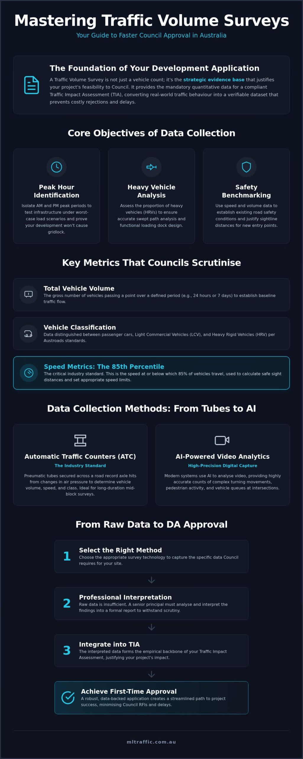
- Peak Hour Identification: Surveys typically isolate the AM and PM peak windows, often 8:00 AM and 5:00 PM, to test infrastructure under worst-case load scenarios.
- Heavy Vehicle Analysis: Assessing the proportion of heavy rigid vehicles is essential for designing functional loading docks and ensuring Vehicle Swept Path Analysis is accurate.
- Safety Benchmarking: Data helps identify if current traffic patterns are stable or if existing speeds pose a risk to future residents.
Key Metrics Collected During a Survey
A professional Traffic Volume Survey provides more than just a simple tally of cars. It offers a granular breakdown of how a road operates in real-time.
- Total Vehicle Volume: The gross number of vehicles passing a specific point over a defined duration, usually 24 hours or a full seven-day week.
- Vehicle Classification: Data distinguishes between passenger cars, light commercial vehicles (LCV), and heavy rigid vehicles (HRV) based on current Austroads vehicle classification standards.
- Speed Metrics: While average speeds are useful, the 85th percentile speed is the critical industry standard. It’s the speed at or below which 85% of vehicles travel. We use this metric to calculate safe sight distances for new driveway entries.
Primary Data Collection Methods: From Pneumatic Tubes to AI Video
Selecting the correct data collection method for a Traffic Volume Survey is a technical decision that directly impacts the reliability of your planning application. Councils often mandate specific methodologies based on the complexity of the road environment and the objectives of the assessment. While traditional methods remain highly effective for baseline volume data, the industry has seen a significant shift toward high-precision digital capture in 2026. Developers must ensure the chosen method aligns with the specific data Council has requested to avoid the cost of re-surveying a site.
The choice of hardware and software depends on whether the project requires mid-block speed data or complex turning movement counts. For many developers, engaging an expert who manages the process from initial quote to final technical execution is the most efficient way to ensure data integrity. You can contact a senior principal to discuss which method suits your specific site constraints.
Automatic Traffic Counters (ATC)
Automatic Traffic Counters remain the industry standard for long-duration mid-block surveys. These units utilise pneumatic tubes, which are rubber hoses secured across the carriageway. As vehicles pass over the tubes, the change in air pressure records axle hits. This allows the counter to determine total volume, vehicle speeds, and classification based on axle spacing. ATC units are the most cost-effective solution for seven-day surveys. They provide the necessary data to capture weekday versus weekend variations, which is a mandatory requirement for most Australian planning authorities. However, these units don’t accurately capture complex turning paths at busy intersections.
Manual Coordination Counts (MCC) and Video Surveys
Intersections and roundabouts require visual observation to track specific turning paths, including left, right, and through movements. While Manual Coordination Counts (MCC) involve personnel on-site, modern standards increasingly favour Video Surveys. High-definition cameras provide a permanent record of the survey period, ensuring complete auditability. If a Council officer disputes the findings, the footage allows for immediate re-analysis and verification.
In 2026, the adoption of AI and computer vision has transformed video data. Sophisticated software now automates the classification of vehicles from video footage with high precision. This technology identifies everything from standard passenger cars to heavy rigid vehicles without the risk of human error. This level of detail is critical for a compliant Traffic Impact Assessment (TIA). Using AI-powered video analysis ensures your data withstands the most rigorous technical scrutiny from local authorities.
Interpreting the Data: 85th Percentile Speed and Peak Hour Volumes
Data interpretation is where raw numbers become actionable engineering evidence. A Traffic Volume Survey provides the essential foundation, but senior principals must apply technical rigour to justify a development’s impact. Council planners don’t just look at how many cars pass a site. They examine how those vehicles behave and how the existing network absorbs new demand. Without expert interpretation, raw data is often dismissed by authorities as insufficient for a formal planning permit.
Why the 85th Percentile Speed Matters
The 85th percentile speed is defined as the speed at or below which 85% of vehicles travel under free-flow conditions. It’s the industry standard for road design because it represents the actual operating speed of the road, which often differs from the posted limit. Designing for the 85th percentile ensures that the majority of drivers can safely navigate site access points without sudden braking or collision risks. It’s a pragmatic approach to safety that accounts for real-world driver behaviour.
This metric is critical for a compliant Sight Distance Assessment. Engineers use this speed to calculate the minimum gap required for a driver to safely exit a new driveway. The calculation of gap acceptance parameters, updated in the January 2026 edition of the Austroads Guide to Traffic Management Part 2, relies heavily on this precise speed data. Ensuring your project meets these standards is mandatory for AS 2890.1 compliance, covering both sight lines and Driveway Ramp Grade Assessments.
Peak Hour Analysis and Site Capacity
Engineers isolate the AM and PM peak periods from a 24-hour dataset to identify the most constrained windows of operation. These typically occur around 8:00 AM and 5:00 PM. We then apply “Trip Generation Rates” to calculate how many new vehicle movements the development will add to these peaks. By adding these projected trips to the existing baseline data, we determine the future total load on the network.
This leads to the calculation of the “Level of Service” (LoS), a qualitative measure ranging from A (free flow) to F (gridlock). It describes intersection performance based on several factors:
- Average vehicle delay at signals or give-way lines.
- Queue lengths during peak periods.
- The ratio of volume to total road capacity.
If a development drops the LoS of a nearby intersection, Council may require costly mitigation measures. Accurate survey data prevents over-engineering these solutions or facing project rejection due to perceived capacity issues. It’s about providing a clear, data-driven argument that your project is viable within the existing infrastructure.
Design and Timing: Ensuring Your Survey Meets Council Requirements
The “Golden Rule” of Australian traffic engineering is that data must be representative. Every Traffic Volume Survey submitted to Council must capture a typical week of road activity. If you conduct a count during school holidays, public holidays, or major local events, the planning authority will likely reject the data. These periods don’t reflect the standard operational load of the road network. Similarly, surveys performed during heavy rain or extreme weather events are often deemed invalid. Adverse weather significantly alters driver behaviour and reduces total volumes. This creates a skewed baseline that fails to withstand technical scrutiny.
Most Australian local government authorities mandate a continuous seven-day survey. This duration is necessary to satisfy requirements for both weekday peak hour analysis and weekend traffic patterns. While a 24-hour count might suffice for minor driveway alterations, larger commercial and residential developments require the full seven-day dataset to prove network capacity. This longitudinal data allows engineers to identify the true peak hour windows and calculate reliable averages that satisfy the latest 2026 Austroads Guide to Traffic Management standards.
The Developer’s Survey Checklist
Before deploying hardware, developers must coordinate with their consultant to ensure the survey design is compliant. Failure to do so leads to expensive re-surveys and project delays. Use this checklist to verify your survey scope:
- Confirm the “Zone of Influence” with a qualified engineer to identify which intersections require turning movement counts.
- Consult the specific Development Control Plan (DCP) for the local Council to verify minimum data duration requirements.
- Ensure the survey captures 85th percentile speeds and vehicle classification alongside raw volume.
- Verify that the survey timing avoids any planned roadworks or temporary traffic management changes in the area.
Avoiding Common Planning Pitfalls
A frequent mistake is the use of “stale” data. As of 2026, most planning authorities consider traffic data valid for only 12 to 24 months. If your site is located in a rapidly developing corridor, Council may require data that is less than a year old to account for recent growth. Relying on outdated figures will jeopardise your DA approval and lead to mandatory requests for further information. Learn more about our comprehensive Traffic Engineering services to ensure your application uses current, compliant data.
One-day snapshots are another false economy. While they appear cheaper, they rarely provide sufficient evidence for a comprehensive Intersection Analysis. Councils increasingly demand multi-day averages to ensure the proposed development doesn’t compromise road safety or the local Level of Service. Ensure your project remains on schedule by contacting our senior principals for a compliant survey plan.
Engaging a Professional Traffic Consultant for Your DA Approval
Council planners rarely accept raw spreadsheets as sufficient evidence for a development application. While the Traffic Volume Survey provides the necessary quantitative foundation, authorities require an interpreted report signed by a qualified traffic engineer to validate the findings. This professional assessment contextualises raw data within the local planning framework and demonstrates that the proposed development won’t adversely impact road safety or network capacity. Engaging a consultant early in the process ensures the survey design addresses specific Council concerns before any hardware is deployed on-site.
A professional assessment can often find “capacity” where a non-expert might only see a “bottleneck.” By applying advanced modelling and technical rigour, a seasoned consultant identifies the specific windows of opportunity that justify a project’s feasibility. This strategic interpretation is a high-ROI investment for developers. It prevents the expensive and time-consuming requests for further information (RFI) that frequently stall applications for months. Providing reliable data that withstands technical scrutiny is the most effective way to manage holding costs during the planning phase.
The ML Traffic Engineers Australia Difference
Direct access to senior principals is a defining characteristic of our professional service. At ML Traffic Engineers Australia, we ensure that the same expert who quotes your job is the one performing the technical analysis and signing the final report. This “no-gatekeepers” approach ensures complete technical accountability and eliminates the communication gaps common in larger, impersonal firms. With over 15 years of consultancy experience and more than 10,000 site assessments completed, we possess the deep-seated expertise required to navigate complex Australian planning requirements. Read about our hands-on approach and expertise to learn how our personnel continuity promise benefits your project.
Securing Your Council Approval with Precision Data
We specialise in translating raw traffic counts into persuasive arguments for your site’s viability. Our team ensures that every Traffic Volume Survey we conduct leads to a comprehensive Traffic Impact Assessment (TIA) Report that satisfies all regulatory bodies. We maintain strict compliance with AS 2890.1, AS 2890.2, and relevant state road authority guidelines to ensure your project meets national standards. By delivering precision data and expert engineering insights, we provide a streamlined path to project approval. Contact ML Traffic Engineers Australia today for a project-specific traffic survey and assessment.
Securing Your Planning Permit with Data Precision
A Traffic Volume Survey represents more than a compliance tick; it is a strategic asset that validates your development’s impact on the Australian road network. By mastering technical requirements like representative timing and the 85th percentile speed, you provide Council with the reliable data needed to avoid costly project delays. Success in the 2026 planning landscape requires moving beyond raw counts to an expert-led interpretation that justifies your project’s feasibility and safety within the existing infrastructure.
ML Traffic Engineers Australia brings over 15 years of consultancy experience and the proven reliability of 10,000 site assessments to your application. Our “no-gatekeepers” philosophy ensures you have direct access to senior principals who perform the technical work from the initial quote to the final report. This hands-on accountability guarantees that your assessments meet AS 2890.1 standards and provide a clear, streamlined path to project approval. We look forward to helping you move your development toward a successful outcome.
Get a Professional Traffic Assessment for Your Project
Frequently Asked Questions
Why does Council require a traffic volume survey for my small development?
Council requires this data to quantify the safety and capacity impacts of your proposal on the local road network. Even small developments contribute to cumulative traffic growth that can affect intersection performance. The survey provides the mandatory baseline data needed to prove your site access won’t compromise community safety or the existing Level of Service. It ensures your application complies with specific Development Control Plan requirements and state road authority standards.
How long does a typical traffic volume survey take to complete?
A standard Traffic Volume Survey typically requires seven consecutive days of data collection to satisfy most Australian planning authorities. This duration is necessary to capture the essential variations between weekday and weekend traffic patterns. Once the hardware is retrieved, technical analysis and the production of a formal engineering report generally take an additional three to five business days. Complex sites requiring AI video analysis may involve slightly longer processing times.
Can I use traffic data from a nearby development for my own DA?
You generally cannot use data from a nearby development because Council requires site-specific evidence. Traffic behaviour and volumes can vary significantly even over short distances due to local driveway conflicts or unique road geometry. Using third-party data often leads to a mandatory request for further information because the dataset fails to account for the specific “Zone of Influence” relevant to your proposed access point and its impact on the immediate network.
What happens if the survey shows the road is already at capacity?
If a Traffic Volume Survey indicates the road is at capacity, a senior principal must identify mitigation strategies or prove your development adds negligible impact. We use the data to perform a detailed Intersection Analysis, which may demonstrate that while total volumes are high, your specific turning movements don’t drop the Level of Service. Accurate data prevents project rejection by providing a nuanced, data-driven argument for your site’s viability despite existing constraints.
How much does a traffic volume survey cost in Australia?
Costs vary significantly based on the number of locations, the duration of the count, and the complexity of the data required. Mid-block surveys using pneumatic tubes are generally more cost-effective than complex intersection counts requiring high-definition video and AI classification. Because every development site has unique technical requirements, you should request a project-specific quote from a senior principal to ensure the survey scope meets Council requirements without unnecessary over-spend on redundant data.
What is the difference between a mid-block count and a turning movement count?
A mid-block count records total volume, speed, and vehicle classification at a point between intersections. It’s the standard method for establishing road capacity and 85th percentile speeds. A turning movement count specifically tracks vehicles as they navigate an intersection, recording left, right, and through movements. Turning counts are essential for modelling intersection delays and determining if a new development will cause local congestion. Both metrics are often required for a complete assessment.
Do I need a new survey if I already have data from two years ago?
You likely need a new survey because most Australian planning authorities consider traffic data “stale” after 12 to 24 months. If there has been significant development in the surrounding area since your last count, the baseline traffic volumes will have changed. Using outdated data is a frequent cause for Council refusal. Fresh data ensures your application reflects current road conditions and survives the technical scrutiny of the assessing traffic engineer.
What is a pneumatic tube survey and is it accurate?
A pneumatic tube survey is a highly accurate method for capturing vehicle volume, speed, and axle-based classification. These systems use rubber hoses secured across the road to record axle hits, which a counter unit then translates into precise datasets. They are the industry standard for seven-day mid-block counts due to their reliability. While they are excellent for straight road segments, they aren’t suitable for intersections where turning movements require visual or AI-powered video tracking.

Disclaimer
The content on www.mltraffic.com.au, including all technical articles, guides, and resources, is provided for general informational and educational purposes only. It is not intended to constitute professional advice in traffic engineering, transportation planning, development approvals, or any other technical or legal field.
While ML Traffic Engineers makes every reasonable effort to ensure the accuracy, completeness, and timeliness of the information published, we do not provide any warranties or representations (express or implied) regarding its reliability, suitability, or availability for any particular purpose. Any reliance you place on the content is strictly at your own risk.
In no event shall ML Traffic Engineers, its directors, employees, authors, or affiliates be liable for any direct, indirect, incidental, special, consequential, or punitive damages (including, without limitation, loss of profits, data, or business opportunities) arising out of or in connection with the use of, or inability to use, any information provided on this website.
The articles and guides on this site are not a substitute for engaging a qualified, registered professional traffic engineer (such as an NPER or RPEQ engineer) to assess your specific project requirements. For tailored advice, compliance assessments, or traffic engineering services, please contact a competent professional.
This disclaimer may be updated from time to time without notice. By accessing or using this website, you agree to be bound by the most current version of this disclaimer.
