

Securing Council approval for a reduced car parking rate hinges on technical justification that goes beyond a standard parking survey. Many Australian developers face significant delays when their initial submission lacks the specific “sustainable transport” data required by local planning authorities. It’s common to feel frustrated by overlapping DA requirements and the lack of clear templates for accessibility compliance. You need a clear understanding of what is a traffic impact assessment report and how a Transport Access Guide (TAG) fits within that technical framework.
This guide explains how a TAG functions as a critical technical document for achieving Council approval. We will break down the essential components of a TAG and its role in justifying parking variances under AS/NZS 2890.1:2021. You’ll also learn how this document integrates into your broader traffic impact assessment report to ensure a streamlined approval process without unnecessary traffic related delays. By providing a technical framework for sustainable transport, a TAG allows you to justify development density and navigate complex regulatory standards, such as the Guide to Transport Impact Assessment 2024, with precision.
Key Takeaways
- Understand how a Transport Access Guide (TAG) acts as a site-specific tool to mitigate vehicle dependency and meet Council requirements for sustainable travel.
- Gain clarity on what is a traffic impact assessment report and how a TAG functions as a necessary appendix to support traffic generation claims and parking reductions.
- Identify the technical components required for a professional TAG, including customised cartography for walking isochrones and detailed transit frequency data.
- Master the two-step preparation process involving physical site audits and comprehensive infrastructure data collection to ensure compliance with Australian standards.
- Discover how direct access to senior principals at ML Traffic Engineers Australia ensures technical reports are managed with accountability from initial site audit to final Council submission.
Defining the Transport Access Guide (TAG) in the Australian Context
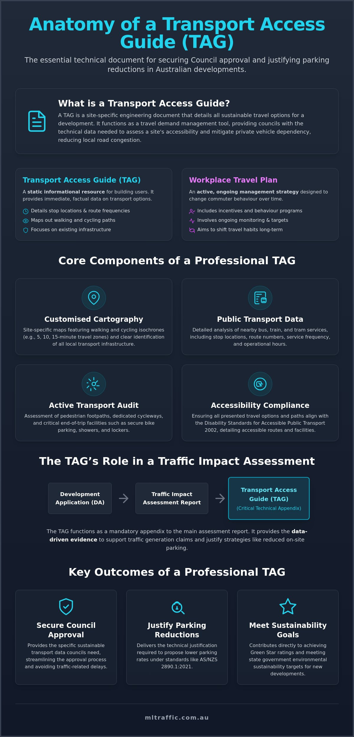
A Transport Access Guide (TAG) is a site-specific technical document detailing sustainable travel options for a building, precinct, or development. It functions as a travel demand management tool used by Australian local Councils to mitigate private vehicle dependency and reduce local road congestion. While a standard map provides general directions, a professional TAG uses technical data to promote active transport, including walking, cycling, and public transport networks. Impact assessments in the civil sector rely on these documents to verify site accessibility and ensure developments align with regional transport goals. By addressing these factors, a TAG helps reduce the 77 hours lost annually to rush hour congestion in many Australian cities.
A Transport Access Guide (TAG) is a professional engineering document required by Councils to demonstrate site accessibility and sustainable transport integration. Developers often ask what is a traffic impact assessment report when preparing a Development Application for a new commercial or residential project. The TAG is frequently a mandatory component of this report, providing the technical justification for a site’s transport strategy and overall traffic generation figures. By integrating a TAG, developers provide evidence of a site’s connectivity to existing infrastructure and justify parking rate reductions. You can find more information on these technical requirements through our traffic engineering services.
To better understand this concept, watch this helpful video:
TAG vs. Travel Plan: Understanding the Nuance
A TAG functions as a static informational resource for site users, providing immediate data on stop locations, route frequencies, and cycling paths. A Workplace Travel Plan is an active, ongoing management strategy that includes specific incentives, monitoring, and performance targets to change commuter behaviour over time. Large-scale commercial developments often require both documents for DA approval to satisfy Council sustainability criteria and long-term traffic management goals. This distinction is vital for those seeking to understand what is a traffic impact assessment report and how its sub-components differ in practical application.
The Shift Toward Sustainable Transport in Australian Planning
Australian urban planning is transitioning away from car-centric design towards transit-oriented development. TAGs are essential for achieving Green Star ratings and meeting environmental sustainability targets set by state governments. A well-prepared TAG supports a case for reduced on-site parking requirements in high-density areas by demonstrating high levels of accessibility. Developers can then justify lower parking rates under AS/NZS 2890.1:2021. This shift ensures developments remain compliant with the Guide to Transport Impact Assessment 2024 and align with the Disability Standards for Accessible Public Transport 2002, which are currently undergoing reform to improve accessibility for all Australians.
Core Components of a Professional Transport Access Guide
A professional Transport Access Guide (TAG) requires technical precision to satisfy Council requirements for sustainable development. Unlike generic brochures, a TAG is an engineering document that provides data-driven evidence of site accessibility. It forms a critical component of the broader Guide to Traffic Impact Assessment framework used across various Australian jurisdictions. When developers query what is a traffic impact assessment report, they must recognise that a TAG is the technical bridge between physical infrastructure and user behaviour. A comprehensive guide includes several mandatory technical elements.
- Customised Cartography: High-quality maps displaying walking and cycling isochrones are essential. These travel time catchments show exactly how far a pedestrian or cyclist can travel from the site centre within 5, 10, or 15 minutes.
- Public Transport Analysis: This section details route frequencies, stop locations, and real-time transit links. It proves the site is serviced by viable alternatives to private vehicle use.
- End-of-Trip Documentation: The guide must verify on-site facilities like secure bicycle parking, lockers, and showers to encourage active commuting.
- Accessibility Compliance: Detailed information on compliant paths of travel, lift locations, and DDA standards ensures the site is usable for people with disabilities.
- Freight and Servicing: Clear arrangements for commercial deliveries ensure freight movements don’t conflict with pedestrian zones or cycle ways.
Technical Mapping and Visual Standards
Engineering cartography is superior to generic digital screenshots. Professional guides use clear icons to identify transport hubs and safe routes for pedestrians and cyclists. Integrating QR codes allows users to access live transit updates, ensuring the document remains a functional tool rather than a static compliance item. This level of detail is necessary to justify parking rate reductions in a what is a traffic impact assessment report submission. Accurate mapping demonstrates a thorough understanding of the local transport network.
Site-Specific Amenities and Compliance
Sustainability and compliance go hand in hand. Bicycle parking and storage must adhere strictly to AS 2890.3 standards to be considered valid by planning authorities. Developers should also detail car-share pod locations and Uber pick-up points to further reduce the need for private car ownership. Promoting on-site electric vehicle (EV) charging stations within the TAG highlights a commitment to modern transport trends. If you require technical assistance with these components, you can contact our senior principals for a detailed consultation.
The TAG’s Role in a Traffic Impact Assessment Report
A Transport Access Guide is rarely a standalone document. It is usually a mandatory appendix or supporting technical paper for a comprehensive traffic impact assessment report. While the primary report focuses on hard engineering data such as intersection capacity, degree of saturation, and vehicle swept paths, the TAG provides the soft mitigation strategies. These strategies justify the traffic generation rates applied to the development model. Without a robust TAG, Councils may default to higher trip generation figures, which can lead to costly requirements for intersection upgrades or increased on-site parking.
Councils use the TAG to verify that a development will not lead to excessive on-street parking demand in the surrounding neighbourhood. By proving that a site has high accessibility to public transport and active travel networks, developers can justify a reduction in private vehicle reliance. A professional TAG demonstrates a developer’s technical commitment to an integrated Traffic Management Plan, ensuring the project remains functional from the construction phase through to full occupation.
Mitigating Traffic Impact through Information
Providing transport information acts as a demand management solution to reduce peak hour congestion. When commuters have immediate access to travel time catchments and transit frequencies, they are statistically more likely to choose non-car modes of transport. This technical link is essential for anyone asking what is a traffic impact assessment report and how it achieves DA approval. High accessibility data within the TAG directly influences the broader Traffic Impact Assessment (TIA). It allows traffic engineers to argue for lower trip generation rates, which can help a project gain approval even when parking provision falls below standard DCP rates.
Compliance with Local Environmental Plans (LEPs)
Every Australian local Council has specific transport objectives outlined in their Local Environmental Plans (LEPs) and Development Control Plans (DCPs). A professional TAG ensures these objectives are met by addressing social equity and ensuring transport information is accessible for non-drivers, visitors, and people with disabilities. This alignment is critical for modern developments. It ensures the site-specific guide supports broader state-level transport strategies and regional infrastructure planning. When considering what is a traffic impact assessment report, developers must view the TAG as the regulatory evidence that the development supports transit-oriented goals rather than contributing to urban sprawl and car dependency.
The Process of Preparing a Technical Transport Access Guide
Preparing a professional Transport Access Guide (TAG) involves a rigorous five-step engineering workflow. It is not merely a graphic design task; it’s a technical requirement that must withstand Council scrutiny. Developers often ask what is a traffic impact assessment report when they receive a request for additional sustainable transport data from Council. The TAG serves as the evidence-based response to these requests, requiring a methodical approach to data verification and site analysis.
- Step 1: Site Audit: We physically assess pedestrian paths, street lighting, and crossing safety within a 400m to 800m radius of the development. This identifies existing barriers to active transport and potential safety hazards.
- Step 2: Data Collection: Our team gathers current transit timetable data, cycling network maps, and local infrastructure plans to ensure the guide reflects the actual transport environment.
- Step 3: Stakeholder Consultation: We liaise with local Council or state transport authorities to confirm specific requirements and ensure the document aligns with regional planning goals.
- Step 4: Drafting and Design: This stage involves creating the visual guide for end-users alongside a supporting technical engineering report for planning officers.
- Step 5: Final Certification: We ensure the completed guide meets all DA “Conditions of Consent” and relevant Australian Standards, including accessibility requirements.
The Essential Role of the Traffic Engineer
A professional traffic engineer is required to verify the safety and practicality of every proposed access route. We analyse pedestrian sightlines and intersection safety to ensure that the “safe routes” promoted in the guide are technically sound. This process includes ensuring that all proposed active transport routes are fully compliant with disability access standards and the latest reforms to the Disability Standards for Accessible Public Transport 2002. Without this engineering oversight, a TAG lacks the authority needed to justify parking rate reductions in a what is a traffic impact assessment report submission.
Maintaining and Updating the Guide
Transport networks are dynamic. We recommend periodic reviews every 2 to 3 years to keep transport data current and accurate. This is especially important when public transport routes change or new cycling infrastructure is completed. Modern developments benefit from digital distribution via QR codes or web portals, though physical copies are still required in many commercial lobbies. Regular updates ensure that the development remains compliant with long-term management requirements. If you need a compliant TAG for your development application, contact our senior principals to discuss your project requirements.
Professional TAG Preparation with ML Traffic Engineers Australia
ML Traffic Engineers Australia brings over 15 years of technical expertise to the Australian development sector. We specialise in the preparation of Transport Access Guides and comprehensive traffic reports that facilitate successful DA outcomes. Our team understands that a TAG is not a standalone item but a critical technical instrument within the broader regulatory framework. When developers ask what is a traffic impact assessment report, they are seeking a document that balances engineering data with strategic planning. We provide that balance, ensuring every submission is meticulous, compliant, and technically robust.
Our service suite covers the full spectrum of traffic engineering requirements for diverse project environments including high-density residential towers, commercial office blocks, and industrial precincts:
- Technical Transport Access Guides (TAG) for residential and commercial developments.
- Vehicle Swept Path Analysis for complex site access and loading docks.
- Car Parking Demand Assessment to justify departures from standard DCP rates.
- Intersection Analysis and Sight Distance Assessment for safety compliance.
- Comprehensive Traffic Impact Assessment (TIA) Reports for all land-use categories.
- Driveway Ramp Grade Assessment and Car Park Design.
Our Meticulous Engineering Approach
We provide certified engineering documents that offer technical rigour. We don’t produce generic maps or simple brochures. Our hands-on philosophy distinguishes our consultancy from larger, more impersonal firms. The senior principal who initiates your project relationship is the same expert who performs the technical work. This continuity ensures deep-seated accountability and precision in every assessment. We have a proven track record of successful negotiations with Councils nationwide, particularly regarding parking rate reductions and sustainable transport justifications. Our results-oriented approach focuses on providing the exact data planning officers require to approve a development without unnecessary traffic related delays. We manage the technical complexities so developers can focus on project delivery.
Secure Your DA Approval Today
Engaging ML Traffic Engineers Australia for your next project ensures your documentation meets all national regulatory standards. We understand the nuances of the Guide to Transport Impact Assessment 2024 and the current reforms to disability standards. Our commitment to providing clear, authoritative, and compliant documentation remains consistent across every project, regardless of scale. We help you navigate the complexities of what is a traffic impact assessment report while delivering a TAG that serves as a functional tool for your development. Our senior leadership remains involved in every project to ensure that technical work adheres to the highest professional standards. Contact ML Traffic Engineers Australia for a TAG quote to secure senior-level expertise for your next development application.
Secure Your Development Approval with Technical Precision
A professional Transport Access Guide is a necessary technical instrument for modern Australian developments. It provides the data-driven justification required to mitigate private vehicle dependency and support requests for reduced car parking rates. By integrating technical mapping and transit frequency data, a TAG ensures your project aligns with current state planning guidelines and accessibility standards like AS 2890. Understanding what is a traffic impact assessment report is the first step in recognising how these sub-documents work together to streamline the Council approval process.
ML Traffic Engineers Australia offers over 15 years of consultancy experience in delivering these specialised reports. We provide direct access to senior traffic engineers who manage your project personally from the initial site audit to final certification. Our results-oriented approach ensures full compliance with local Council requirements and national standards, reducing the risk of traffic related delays. Contact our senior principals to discuss your Transport Access Guide requirements and ensure your next Development Application is backed by technical expertise. We look forward to helping you achieve a successful and compliant project outcome.
Frequently Asked Questions
Is a Transport Access Guide legally required for all DAs?
A Transport Access Guide is not legally mandated for every Development Application in Australia. Its requirement is typically triggered by specific clauses within a local Council’s Development Control Plan (DCP) or Local Environmental Plan (LEP). Planning authorities usually request a TAG for high-density residential, commercial, or mixed-use developments where sustainable transport targets and travel demand management are priorities.
How does a TAG differ from a full traffic impact assessment report?
A TAG functions as a technical subset or supporting appendix to a broader assessment. When considering what is a traffic impact assessment report, it’s important to distinguish between hard engineering data and soft travel demand management. The TIA focuses on intersection capacity, degree of saturation, and vehicle swept paths, while the TAG details pedestrian connectivity and public transport frequencies.
Can I create a Transport Access Guide myself using Google Maps?
You cannot create a compliant TAG using generic digital tools like Google Maps. Councils require professional engineering cartography that includes travel time isochrones and verified safe routes. A professional guide must also certify compliance with disability access standards and AS 2890.3, which requires a physical site audit and technical verification by a qualified engineer.
Does a TAG cover delivery and service vehicle access?
Yes, a comprehensive TAG must address delivery and service vehicle access. It documents how freight movements and commercial servicing are managed to prevent conflicts with pedestrian zones and cycling paths. This ensures the site remains safe for active transport users while maintaining functional commercial operations and adhering to the site’s overall traffic management strategy.
How much does a professional TAG cost to prepare?
Preparation costs depend entirely on the scale of the development and the specific data requirements of the local Council. Factors influencing the total investment include the radius of the physical site audit, the complexity of the local transit network, and the depth of the required technical engineering report. Engaging a senior traffic engineer ensures the document meets DA “Conditions of Consent” efficiently.
What is the difference between a TAG and a Green Travel Plan?
A TAG is a static informational resource designed to provide immediate transport data for site users and visitors. A Green Travel Plan, or Workplace Travel Plan, is an active management document that includes ongoing monitoring, performance targets, and specific incentives to change commuter behaviour over time. Large-scale projects often require both documents to satisfy sustainability and environmental criteria.
How does a TAG help with Council car parking requirements?
A TAG justifies car parking rate reductions by providing technical evidence of high site accessibility. It allows traffic engineers to argue for lower parking rates under AS/NZS 2890.1:2021 by proving that residents or employees have viable alternatives to private vehicle use. This is a critical component of what is a traffic impact assessment report when seeking to maximise development density in high-growth areas.
How often should a Transport Access Guide be updated after development?
Transport Access Guides should undergo periodic reviews every 2 to 3 years to maintain technical accuracy. This ensures that transit frequencies, route locations, and local cycling infrastructure data reflect the current transport network. Regular updates are often a condition of the operational management plan for major commercial precincts to ensure long-term compliance with Council sustainability targets.

Disclaimer
The content on www.mltraffic.com.au, including all technical articles, guides, and resources, is provided for general informational and educational purposes only. It is not intended to constitute professional advice in traffic engineering, transportation planning, development approvals, or any other technical or legal field. While ML Traffic Engineers makes every reasonable effort to ensure the accuracy, completeness, and timeliness of the information published, we do not provide any warranties or representations (express or implied) regarding its reliability, suitability, or availability for any particular purpose. Any reliance you place on the content is strictly at your own risk. In no event shall ML Traffic Engineers, its directors, employees, authors, or affiliates be liable for any direct, indirect, incidental, special, consequential, or punitive damages (including, without limitation, loss of profits, data, or business opportunities) arising out of or in connection with the use of, or inability to use, any information provided on this website. The articles and guides on this site are not a substitute for engaging a qualified, registered professional traffic engineer (such as an NPER or RPEQ engineer) to assess your specific project requirements. For tailored advice, compliance assessments, or traffic engineering services, please contact a competent professional. This disclaimer may be updated from time to time without notice. By accessing or using this website, you agree to be bound by the most current version of this disclaimer.
