
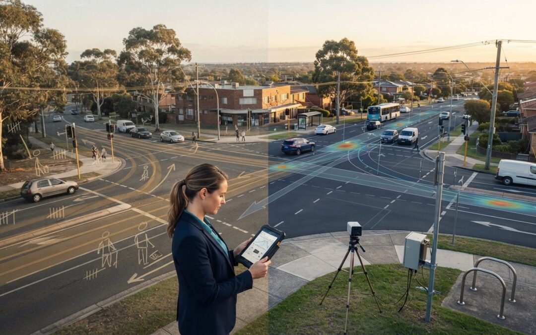
Relying on free traffic data from a council website to support your Development Application (DA) is a high-stakes gamble that frequently leads to costly project delays. While it’s tempting to use existing records to reduce initial consultancy costs, these figures often fail to reflect current road conditions or recent local developments. Understanding why council traffic data may be outdated is critical for any developer aiming to avoid unexpected council objections or expensive Requests for Further Information (RFI).
You likely expect that data provided by a local authority is the gold standard for your Traffic Impact Assessment (TIA). However, many council counts are several years old and don’t account for post-pandemic shifts in transport patterns or new infrastructure. This article demonstrates how historic data can jeopardise your application and outlines the steps to ensure your submission meets strict AS 2890 standards. We will cover the risks of redundant surveys, the importance of accurate intersection analysis, and how to secure a smooth planning approval process through technical precision and senior-led data integrity.
Key Takeaways
- Understand why council traffic data may be outdated due to data latency and how historic counts can trigger immediate Requests for Further Information (RFI).
- Identify how post-pandemic travel shifts and nearby induced demand render many public traffic records obsolete for modern Traffic Impact Assessments.
- Avoid failing the mandatory ‘No Worsening’ test by using current intersection analysis to provide accurate Level of Service (LoS) calculations.
- Implement the ‘Three-Year Rule’ to treat any traffic data older than 36 months as high-risk for your development application’s success.
- Ensure your submission meets AS 2890 standards by prioritising senior-led data verification to navigate complex council requirements.
The Hidden Risks of Historic Council Traffic Data
Council traffic data exists primarily for regional road network planning rather than individual development applications. This distinction is critical for developers to understand before they commit to a project timeline. While a local authority may maintain public data portals, these records often suffer from significant data latency. This term describes the temporal gap between the date a traffic count was performed and the current real-world traffic conditions. Understanding why council traffic data may be outdated is the first step in protecting your project from regulatory friction and unexpected costs.
A professional traffic engineer must vet all historic data before it’s included in a formal submission. Councils often provide their own internal data to applicants as a starting point. However, the assessing officer may later reject a report based on that same data if it fails to account for recent local traffic growth or infrastructure changes. This internal contradiction can lead to a complete restart of the assessment process. It’s a common scenario where the data used to justify a project is the very reason it’s ultimately refused.
The Difference Between Open Data and Planning Data
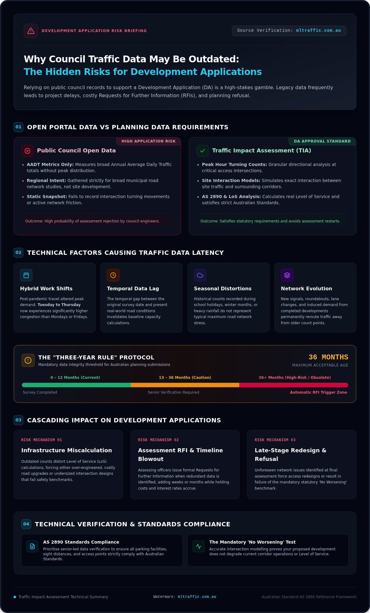
Open data portals usually host legacy datasets that haven’t been updated for several years. These sets typically provide Annual Average Daily Traffic (AADT) counts, which measure total daily volume. While useful for broad municipal studies, AADT is insufficient for a modern Traffic Impact Assessment. Planning authorities require much higher granularity, specifically peak hour turning movements at key intersections. These movements are governed by complex traffic flow measurement principles that AADT counts simply cannot capture. Without this level of detail, your model will fail to predict how a new site actually interacts with the existing road network, leading to immediate rejection by council engineers.
Why ‘Free’ Data Can Become an Expensive Mistake
Using ‘free’ data is a frequent cause of budget blowouts in Australian development. When a council identifies that a submission relies on obsolete counts, they will issue a formal Request for Further Information (RFI). This doesn’t just cost the price of a new survey; it adds weeks or months to the project timeline. During this period, developers face mounting project holding costs and potential interest rate fluctuations. The technical risks include:
- Infrastructure Miscalculation: Outdated counts lead to incorrect Level of Service (LoS) results, forcing either oversized, expensive upgrades or undersized designs that fail safety standards.
- Late-Stage Objections: Planners often identify ‘unforeseen’ traffic issues during the final assessment phase if the initial data was flawed, requiring a complete redesign of access points.
- Compliance Failure: Data that doesn’t meet current AS 2890 standards will be flagged, regardless of whether the council provided it.
Relying on historic records without professional verification is a high-stakes gamble. Identifying why council traffic data may be outdated early in the process allows for the commissioning of accurate, site-specific surveys that satisfy council requirements the first time.
Technical Factors That Cause Traffic Data Latency
Road environments are dynamic systems that evolve far faster than municipal data collection cycles. A council traffic count is a static snapshot, often failing to capture the rapid evolution of a precinct. This is a primary reason why council traffic data may be outdated by the time a developer submits a DA. Post-pandemic travel patterns have permanently shifted peak-hour distributions. Hybrid work models mean Tuesday through Thursday now experience significantly higher congestion than Mondays or Fridays. Historic data collected before these shifts occurred misses this nuance entirely, leading to inaccurate capacity modelling.
Environmental and seasonal factors also compromise the integrity of older datasets. Counts taken during school holidays, winter months, or periods of heavy rain are non-representative of typical maximum road stress. Similarly, recent infrastructure changes nearby, such as new traffic signals, lane reconfigurations, or roundabouts, reroute traffic away from historic count points. This renders older datasets technically invalid for precise intersection analysis. Induced demand from recently completed local projects further compounds this issue, as new residents and commercial tenants add unrecorded volume to the network every month.
The Impact of Local Development Pipelines
Background traffic does not grow at a linear rate. In high-growth corridors, volume increases exponentially as new projects come online. A professional assessment must include the ‘committed development’ list, which accounts for projects approved but not yet constructed. If a council count dates back to 2023, it misses every approval granted in the last 24 months. For a 2026 DA submission, 2023 data is effectively obsolete and will likely trigger an RFI. Developers should speak with an expert engineer to verify if nearby approvals have already fundamentally changed the local traffic profile.
Changing Transport Modes and Micro-mobility
Modern traffic engineering now accounts for multi-modal shifts that historic ‘car-only’ counts ignore. The surge in delivery vehicle movements has altered kerbside traffic flow and increased short-term parking demand in ways that 2019 or 2021 data cannot reflect. Simultaneously, many Australian councils now prioritise active transport, requiring detailed counts of cycling and pedestrian movements. Relying on car-centric data from five years ago ignores these critical safety and capacity factors, which are now mandatory components of a compliant Traffic Impact Assessment.
- Hybrid Work Impact: Peak hours have compressed or shifted days, making mid-week counts essential.
- Infrastructure Rerouting: New local roadworks can permanently change how drivers navigate a precinct.
- Data Gaps: Older counts rarely include e-scooters, delivery vans, or heavy pedestrian flow.
How Outdated Data Jeopardises Development Applications (DAs)
Submitting a Traffic Impact Assessment (TIA) based on flawed baseline data is a primary cause of DA refusal or indefinite delays. If the underlying traffic volumes are incorrect, every subsequent calculation in your report is technically compromised. Inaccurate volume counts lead directly to faulty Level of Service (LoS) results for surrounding intersections. This is a critical reason why council traffic data may be outdated and why it acts as a liability during the assessment phase. When a council engineer identifies that the reported LoS doesn’t match current road performance, the entire credibility of the submission is lost.
Most Australian councils now enforce a strict ‘No Worsening’ test for new developments. This requires developers to prove that their project won’t degrade the existing performance of the road network. If you rely on five-year-old council counts, your ‘base case’ scenario is likely over-optimistic. You may inadvertently claim a project has no impact, only for the council to prove otherwise using their knowledge of recent congestion growth. This discrepancy also affects car parking demand assessments. If the surrounding street activity has increased beyond what historic records show, your proposed parking provision may be deemed insufficient, leading to a forced reduction in yield or expensive basement redesigns.
AS 2890 Compliance and Driveway Design
Compliance with AS 2890.1 isn’t just a matter of geometry; it’s a matter of volume. Driveway width and required queuing areas are directly dictated by the peak hour volumes of the frontage road. If your data underestimates this traffic, your driveway design will likely fail to provide adequate queuing space, causing vehicles to spill back onto public roads. This creates a significant safety risk. Furthermore, sight distance assessments at site access points become invalid if the speed environment or traffic density has changed since the last council count. Road frontage classifications can shift from ‘local’ to ‘collector’ as areas densify, triggering much stricter design requirements that old data simply won’t reflect.
Intersection Capacity and SIDRA Modelling
Intersection analysis using SIDRA software follows the ‘garbage in, garbage out’ principle. The software requires precise, current turning movements to produce a reliable model. Council assessing officers always scrutinise the ‘base case’ model before they even look at the ‘proposed’ model. If the base case is built on obsolete data, the entire simulation is discarded. Underestimating queue lengths in a TIA report is a major red flag. If the model predicts a 10-metre queue but the council knows the real-world queue is 50 metres, the developer will be forced to commission new surveys and redo the entire technical analysis. This often reveals a need for complex Swept Path Analysis for heavy vehicles that wasn’t previously accounted for, further complicating the approval path.
Verifying Data Integrity: When to Commission New Traffic Surveys
Developers must adopt a rigorous risk assessment framework to determine if existing datasets are fit for purpose. Relying on historic records without verification often leads to technical challenges during the DA assessment phase. The most critical benchmark is the ‘Three-Year Rule’. Any data older than 36 months should be treated with extreme caution. In high-growth corridors, even two-year-old data may be obsolete due to the rapid pace of local construction. Understanding why council traffic data may be outdated requires looking beyond the timestamp and assessing the ‘Significant Change’ triggers in the surrounding road network.
These triggers include the completion of nearby residential towers, new commercial precincts, or modifications to local signal timings. If the surrounding 1km radius has seen substantial development since the last count, the historic data is no longer representative. To mitigate this risk, developers can commission ‘Spot Checks’. This involves a targeted, short-term count to validate historic council data against current reality. If the spot check reveals a variance of more than 10 per cent, a full new survey is a technical necessity. Modern technology, such as AI-integrated cameras and pneumatic tube counts, has made fresh surveys faster and more cost-effective than traditional manual counting methods.
A Developer’s Checklist for Traffic Data
Before including council-sourced data in a submission, verify the following parameters:
- Timestamp Verification: Was the count conducted during a neutral mid-week period? Avoid data from school holidays or public holiday weeks.
- Spatial Relevance: Does the count cover the specific turning movements at the intersections required by the council’s engineering department?
- Growth Assessment: Has the ‘committed development’ list for the area grown significantly since the data was recorded?
The ROI of Fresh Traffic Surveys
Commissioning new surveys is a strategic investment rather than a mere project cost. It provides a defensible position if the project faces scrutiny in a planning tribunal or court. Accurate data ensures your TIA report is robust, reducing the probability of a ‘deferred commencement’ or outright refusal. Additionally, current data allows for optimised car park design. By proving actual demand rather than relying on inflated historic projections, developers can often save on construction costs by avoiding unnecessary ramps or oversized basement levels. To ensure your project is built on accurate foundations, contact our senior principals for a data verification review.
Professional Traffic Engineering: Ensuring Data Accuracy for Planning Success
Securing a DA approval requires more than just submitting a report; it requires a technical defence of every data point used in your modelling. Understanding why council traffic data may be outdated is only the first step. The second is implementing a professional verification protocol that satisfies the scrutiny of council assessing officers. ML Traffic Engineers Australia employs a rigorous methodology for data procurement, ensuring that every Traffic Impact Assessment (TIA) is built on current, site-specific reality rather than legacy municipal records. We coordinate directly with specialist survey firms to deploy AI cameras and pneumatic tube counters, providing a granular view of intersection performance that generic council counts cannot match.
Our vetting process involves a multi-stage review of all raw data. We don’t simply accept survey results; we interpret them through the lens of current Australian Standards and local planning requirements. This meticulous approach ensures your TIA is robust enough to withstand the technical challenges often raised by council engineers during the assessment phase. By identifying potential traffic issues before the council does, we allow developers to address constraints through design rather than facing a late-stage refusal.
The ML Traffic Engineers Australia Advantage
With over 15 years of experience and more than 10,000 sites completed, we’ve developed a deep understanding of the specific data requirements for councils across Australia. Our brand is built on direct accountability and technical excellence. Key advantages of our professional approach include:
- Senior Principal Involvement: Senior principals Michael Lee and Benny Chen are directly involved in every project, ensuring that 30+ years of combined expertise is applied to your data interpretation.
- Personnel Continuity: The engineer who initiates your project relationship is the one performing the technical work. We don’t pass projects to junior staff, which ensures data integrity throughout the DA process.
- Fact-Based Reporting: Our reports focus on technical compliance and precision, significantly reducing the likelihood of a Request for Further Information (RFI) or budget-draining delays.
- Comprehensive Technical Suite: We integrate traffic counts with Swept Path Analysis and Car Parking Demand Assessments to provide a holistic view of site performance.
Next Steps for Your Development Application
Avoid the high-stakes gamble of using historic counts for your next submission. We recommend a preliminary data review for any proposed site to determine if existing council records are technically usable or if fresh surveys are required. To begin this process, we typically require a site plan and any previous traffic reports associated with the land. You can contact our senior principals directly to discuss your project’s specific traffic requirements and ensure your data meets current planning standards. Our team is ready to provide the authoritative, fact-based reporting necessary for a smooth planning approval process.
Securing Your Development Approval with Validated Data
Relying on historic counts presents a significant risk to your project’s timeline and budget. This article has detailed why council traffic data may be outdated, highlighting how post-pandemic travel shifts and the limitations of AADT figures compromise modern SIDRA modelling. Using obsolete data often leads to costly RFIs and design failures that breach AS 2890 compliance. To ensure a smooth planning process, developers must prioritise technical integrity through current, site-specific surveys and expert interpretation.
ML Traffic Engineers Australia provides the technical rigour required to navigate complex council requirements. With 30+ years of combined expertise and more than 10,000 successful projects completed nationwide, we ensure your Traffic Impact Assessment is defensible and accurate. You’ll benefit from direct senior principal involvement on every project, ensuring your data meets the highest regulatory standards. Don’t let legacy data jeopardise your application’s success. Contact ML Traffic Engineers Australia for a Professional Traffic Assessment to verify your site’s data requirements today. We look forward to helping you achieve a successful planning outcome.
Frequently Asked Questions
How old can traffic data be for a council DA in Australia?
Most Australian councils require traffic data to be no older than three years. However, in high-growth corridors or precincts undergoing rapid infrastructure changes, data older than 12 to 24 months is often rejected. Assessing officers look for data that reflects current network stress. If significant local developments have been completed since the last count, you will likely need a fresh survey to avoid a Request for Further Information (RFI).
Can I use Google Maps traffic data instead of a formal survey?
Google Maps traffic data is unsuitable for a formal Development Application. While it provides a qualitative overview of congestion, it lacks the quantitative granularity required for SIDRA modelling or intersection analysis. Planning authorities require precise peak-hour turning movements and vehicle classifications, such as heavy vehicles versus cars. Only a formal traffic survey using pneumatic tubes or AI cameras provides the defensible data necessary to meet AS 2890 and council engineering standards.
What happens if the council’s data contradicts my traffic engineer’s survey?
When a professional survey contradicts historic council records, the most recent, site-specific data typically takes precedence. Your traffic engineer must provide a technical justification for the variance, such as changes in local land use or travel patterns. This is a primary reason why council traffic data may be outdated; it fails to capture recent shifts. A robust methodology and senior-led data verification ensure your report stands up to council scrutiny during the assessment phase.
Do I need a fresh traffic count for a minor change of use application?
A fresh count is not always mandatory for minor change of use applications if the traffic generation remains similar to the approved use. However, if the new use alters peak-hour demand or access requirements, councils may still request current data. We recommend a preliminary assessment to determine if existing counts are sufficient. If the frontage road classification has changed or congestion has visibly increased, fresh data protects you from late-stage objections or project delays.
How much does a typical traffic volume survey cost for a DA?
Survey costs vary significantly based on the number of intersections, the duration of the count, and the technology used. Factors such as the requirement for 24-hour tube counts versus peak-period manual or AI camera observations influence the final investment. While we don’t provide fixed industry pricing, fresh surveys are generally more cost-effective than the holding costs associated with a delayed DA or a forced redesign due to the use of obsolete data.
What are ‘peak hour turning movements’ and why are they important?
Peak hour turning movements record the specific volume of vehicles turning left, right, or travelling through an intersection during the morning and afternoon periods of highest demand. These metrics are critical because they determine the Level of Service (LoS) and queue lengths. Generic daily volume counts cannot provide this detail. Accurate turning data is essential for SIDRA modelling to ensure your proposed site access does not compromise the existing road network’s safety or efficiency.
Can seasonal traffic shifts like school holidays affect my DA approval?
Seasonal shifts significantly impact DA approvals because traffic counts must be representative of typical maximum road stress. Surveys conducted during school holidays or public holiday periods are usually rejected by councils as they underestimate commuter congestion. To ensure compliance, counts should be performed during neutral mid-week periods. Failing to account for these variations is a common reason why council traffic data may be outdated or technically invalid for a planning submission.
Why is SIDRA modelling required if I already have volume counts?
Volume counts only provide raw data; SIDRA modelling uses that data to simulate how an intersection actually performs under load. The software calculates delays, degree of saturation, and queue lengths. These results are mandatory for proving your development meets the ‘No Worsening’ test required by Australian planning authorities. Without SIDRA modelling, you cannot demonstrate that your site access and the surrounding network can safely accommodate the additional traffic generated by your proposed development.

Disclaimer
The content on www.mltraffic.com.au, including all technical articles, guides, and resources, is provided for general informational and educational purposes only. It is not intended to constitute professional advice in traffic engineering, transportation planning, development approvals, or any other technical or legal field.
While ML Traffic Engineers makes every reasonable effort to ensure the accuracy, completeness, and timeliness of the information published, we do not provide any warranties or representations (express or implied) regarding its reliability, suitability, or availability for any particular purpose. Any reliance you place on the content is strictly at your own risk.
In no event shall ML Traffic Engineers, its directors, employees, authors, or affiliates be liable for any direct, indirect, incidental, special, consequential, or punitive damages (including, without limitation, loss of profits, data, or business opportunities) arising out of or in connection with the use of, or inability to use, any information provided on this website.
The articles and guides on this site are not a substitute for engaging a qualified, registered professional traffic engineer (such as an NPER or RPEQ engineer) to assess your specific project requirements. For tailored advice, compliance assessments, or traffic engineering services, please contact a competent professional.
This disclaimer may be updated from time to time without notice. By accessing or using this website, you agree to be bound by the most current version of this disclaimer.
